- Delmar Loop Trolley
-
Delmar Loop Trolley 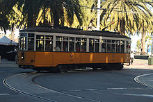
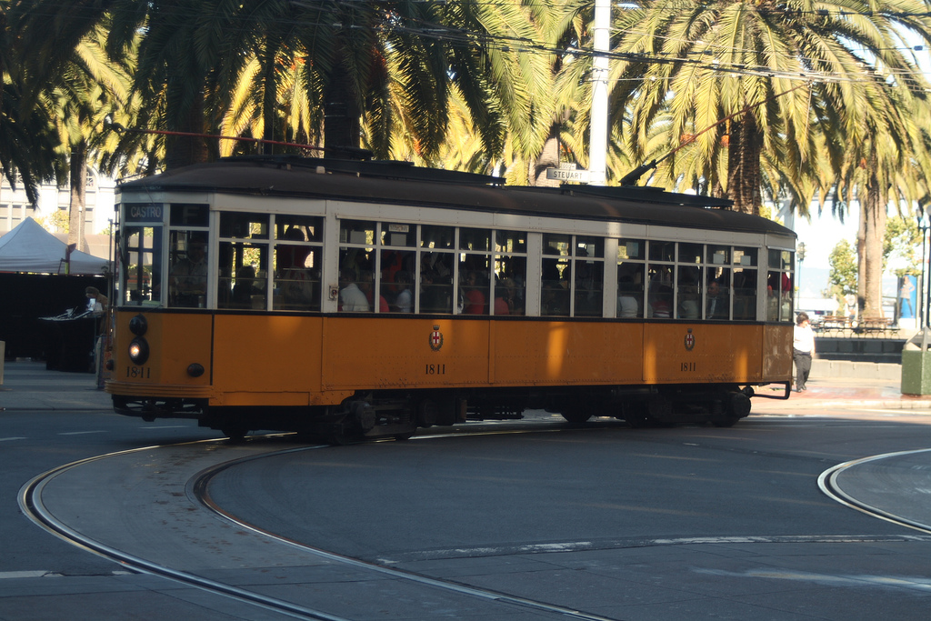
An ex-Milan Peter Witt streetcar restored and running in San Francisco with its original colorsOverview Type Streetcar Status Planning Locale St. Louis Stations 9 (projected) Operation Opened late 2012 (projected) Owner City of St. Louis Operator(s) Bi-State Development Agency Technical Line length 2.2 miles Track gauge 1,435 mm (4 ft 8 1⁄2 in) Route map Legend
History Museum 
Forest Park 
Crossroads School Laurel & Delmar Delmar The Pageant Tivoli Market 
Trinity/Kingsland This route map:
The Delmar Loop Trolley is a 2.2-mile (3.5 km) planned heritage trolley line that will serve the Delmar Loop district in St. Louis, Missouri and University City, Missouri. The line will have about 9 stations and serve the Missouri History Museum in Forest Park, Washington University in St. Louis, two MetroLink stations; Forest Park-DeBaliviere station and Delmar Loop station, University City City Hall, and all the Delmar Loop attractions. The system will use seven replica-historic streetcars instead of earlier plans to use two Peter Witt-type streetcars, because of the state law that requires transit vehicles to aid people with walking disabilities and other reasons, including to permit stops to be positioned on either side of the track (the streetcars will be able to load from either side).[1] A grant of $25 million in Federal Transit Administration (FTA) funding for the project was approved in July 2010, as part of the FTA's Urban Circulator Grant Program.[2][3]
Contents
History
St. Louis ran Peter Witt-type streetcars from 1927 to 1951. Later, PCC streetcars manufactured by the St. Louis Car Company plied the streets until ultimately being shut down in the Great American streetcar scandal. The Delmar Loop originally got its name from the streetcar turnaround which occupied two oblong blocks on the north side of Delmar east from Kingsland Avenue. The loop was used by the Olive-Delmar line. The Creve Coeur line coming south up Kingsland also terminated at the Loop, with the cars backing into it from Kingsland. The loop originally was located adjacent to the Delmar Gardens amusement park, a vestige of which are Eastgate and Westgate avenues, located at the east and west gates of the park. Another streetcar line, the Kirkwood-Ferguson line, traveled north and south a few blocks east of the Loop. And a private line to what is now University City Hall extended west down Delmar.
When the streetcars were replaced with buses the Loop retained its name. Years later, the idea of bringing back streetcars found a champion in Joe Edwards, the owner of Blueberry Hill, The Pageant, and a number of other Loop businesses. Edwards secured the purchase of two restored Peter Witt streetcars that once operated in Milan, Italy and has led the initiative for a new line in conjunction with Citizens for Modern Transit.[citation needed]
The two cars were parked along the route—one on Delmar by Commerce Bank, and the other at the History Museum.[when?] Not conforming to ADA regulations, the cars will remain parked. The planned line will run with new handicapped-accessible streetcars.
Proposed route
The route will loop around the Missouri History Museum. It will then run north on DeBaliviere Avenue in St. Louis. It will then turn west on Delmar Boulevard to the Delmar Station and cross the St. Louis City/County Boundary to University City to serve the Delmar Loop. A possible site for the west end terminus is a roundabout (traffic circle) at Trinity Avenue and Kingsland Street.
Proposed stations
- Missouri History Museum
- Forest Park Metro
- Crossroads College Preparatory School
- Laurel & Delmar
- Delmar MetroLink Station
- Pageant
- Market
- Tivoli
- Trinity/Kingsland
See also
- Streetcars in St. Louis
- Streetcars in North America
- St. Charles City Streetcar
- St. Louis Metrolink
References
- ^ Loop Trolley News
- ^ "U.S. Transportation Secretary Ray LaHood Announces $293 Million for New Transit Solutions, Economic Development Nationwide". Federal Transit Administration. July 8, 2010. http://www.fta.dot.gov/news/news_events_11823.html. Retrieved 2010-07-20.
- ^ "Urban Circulator/Bus and Bus Livability Project Descriptions". Federal Transit Administration. July 8, 2010. http://www.fta.dot.gov/news/news_events_11820.html. Retrieved 2010-07-20.
External links
Public transportation in Greater St. Louis Public Transit Agencies Missouri: Bi-State Development Agency • St. Charles Area Transit Illinois: Madison County Transit • St. Clair County Transit DistrictLocal and express bus service Bus rapid transit St. Louis Bus Rapid TransitLight rail St. Louis MetroLink: (List of stations) Red Line • Blue LineStreetcar Streetcars in St. Louis • Delmar Loop Trolley • St. Charles City StreetcarParatransit Commuter rail St. Louis Commuter RailIntercity rail Airport Other Transportation in St. Louis, Missouri • Gateway Arch • Eads BridgeItalics denote lines or service which are planned, or not operating at this present time Developments in St. Louis Other Buildings Other Projects Public Transportation Lambert Airport expansion • Metrolink Expansion • New Mississippi River Bridge • Delmar Loop Trolley • Memorial Dr.St. Louis MetroLink St. Louis MetroLink services MetroLink system features Eads Bridge • Vandeventer Avenue Bridge • St. Louis Freight Tunnel • Central West End Tunnel • Union Station TunnelRolling Stock Siemens SD-400 • Siemens SD-460Maintenance facilities and shops Ewing Yard • 29th Street YardConnections Forest Park-DeBaliviere • Gateway Multimodal Transportation Center • Lambert-St. Louis International Airport • MetroBikeLink TrailConnecting Services MetroBus • Madison County Transit • St. Charles Area Transit • Metro Call-A-Ride • Delmar Loop TrolleyMetroLink Expansion Daniel Boone Corridor • MetroNorth Corridor • MetroSouth Corridor • MetroWest Corridor • NorthWest Connector • NorthSide Corridor • SouthSide Corridor • St. Charles Corridor • SouthWest Corridor • MidAmerica Extension Phase 3 • Madison County CorridorsOperators Bi-State Development Agency • St. Clair County Transit DistrictItalic denote lines or services which are proposed and planned. Categories:- Bi-State Development Agency
- Delmar Loop Trolley
- Streetcars in Greater St. Louis
- Proposed public transportation in the United States
- Transportation in St. Louis, Missouri
- Rail in St. Louis, Missouri
- Heritage streetcar systems
Wikimedia Foundation. 2010.