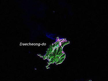
- Daecheong Island
-
Daecheong Island 
Korean name Hangul 대청도 Hanja 大青島 Revised Romanization Daecheongdo McCune–Reischauer Taech‘ŏngdo Daecheong Island is a 12.63 square km (4.88 square miles) island in Ongjin County, Incheon, South Korea, located near the Northern Limit Line.[1] The 1953 s:Korean Armistice Agreement which ended the Korean War specified that the five islands including Daecheong Island would remain under U.N. and South Korea control. This agreement signed by both DPRK and United Nations Command.[2] Since then, it serves as a maritime demarcation between North and South Korea in the Yellow Sea (also called West Sea).
The island is located 19 km (12 mi) from the coast of South Hwanghae province in North Korea.[3]
Contents
Economy
Fishing is popular on the island. Until the late 1980s, skate fishing was a growing industry.[3]
Environment
The island is said to be at the northernmost natural range of the camellia japonica.[4]
Neighboring islands
Two islands nearby are Baengnyeong Island and the much smaller Socheong Island.
2009 battle
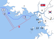 The disputed maritime boundary between North and South Korea in the Yellow Sea:[5]
A: United Nations Command-created Northern Limit Line, 1953[6]
B: North Korea-declared "Inter-Korean MDL", 1999[7]
The locations of specific islands are reflected in the configuration of each maritime boundary, including- 1–Yeonpyeong Island
- 2–Baengnyeong Island
- 3–Daecheong Island
Other map features4-Jung-gu (Incheon Intl. Airport), 5-Seoul, 6-Incheon, 7-Haeju, 8-Kaesong, 9-Ganghwa County, 10-Bukdo Myeon, 11-Deokjeokdo, 12-Jawol Myeon, 13-Yeongheung MyeonMain article: Battle of DaecheongOn 10 November 2009, the waters near the island were the scene of a skirmish between the South Korean and North Korean navies. A patrol boat from North Korea was seriously damaged while the navy of South Korea sustained no casualties.[8]
References
- ^ Yŏnʼguwŏn, Hanʼguk Kukpang (1999). Defense white paper. Ministry of National Defense, Republic of Korea.
- ^ Armistice Agreement, paragraph 13(b). "Text of the Korean War Armistice Agreement". FindLaw. 1953-07-27. http://news.findlaw.com/wp/docs/korea/kwarmagr072753.html. Retrieved 2010-11-25.
- ^ a b Daecheongdo Island. Visit Incheon.
- ^ "Daecheong-do". Galbijim.
- ^ Ryoo, Moo Bong. (2009). "The Korean Armistice and the Islands," p. 13 (at PDF-p. 21). Strategy research project at the U.S. Army War College; retrieved 26 Nov 2010.
- ^ "Factbox: What is the Korean Northern Limit Line?" Reuters (UK). November 23, 2010; retrieved 26 Nov 2010.
- ^ Van Dyke, Jon et al. "The North/South Korea Boundary Dispute in the Yellow (West) Sea," Marine Policy 27 (2003), 143-158; note that "Inter-Korean MDL" is cited because it comes from an academic source and the writers were particular enough to include in quotes as we present it. The broader point is that the maritime demarcation line here is NOT a formal extension of the Military Demarcation Line; compare "NLL—Controversial Sea Border Between S.Korea, DPRK, " People's Daily (PRC), November 21, 2002; retrieved 22 Dec 2010
- ^ Foster, Peter (11 November 2009). "North and South Korean ships exchange fire". The Daily Telegraph. http://www.telegraph.co.uk/news/worldnews/asia/southkorea/6536557/North-and-South-Korea-warships-exchange-fire.html.
External links
- Official website
- Official website (Korean)
Categories:- Islands of South Korea
- Incheon
- Islands of the Yellow Sea
- South Korea geography stubs

Wikimedia Foundation. 2010.