- Baengnyeong Island
Infobox Korean name
hangul=백령도
hanja=白翎島
rr=Baengnyeongdo
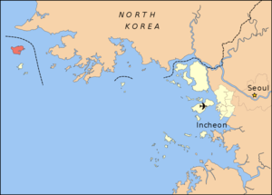
mr=PaengnyŏngdoBaengnyeong Island (sometimes spelled Baekryeong) is an island in Ongjin County,
Incheon ,South Korea located near theNorthern Limit Line , which is the maritime demarcation between North and South Korea. It lies at coord|37|58|N|124|39|E.The meaning of its name is "Island of the white wings", since the island resembles an
Ibis flying with the wings spread.cite web|url=http://100.naver.com/100.nhn?docid=72533|title=네이버 :: 백과사전|publisher=네이버|accessdate=2006-05-16]Numerous North Korean defectors have boated here to escape economic and political conditions in their homeland.
South Korean Natural Treasures #391–#393 are located on Baengnyeong Island.
Overview
Baengnyeong Island is the westermost point of South Korea. Travel time by boat to the island from Incheon is about four hours. ko icon [http://ksum.org/g4/bbs/board.php?bo_table=sum&wr_id=432&sca=%C0%CE%C3%B5%B1%A4%BF%AA%BD%C3&sfl=wr_subject%7C%7Cwr_content&stx=%B9%E9%B7%C9%B5%B5&sop=and 한국의 섬 (Islands of Korea)] ]
Changsan Cape in
Ryongyon , North Korea can be seen from Baengnyeong on clear days.Environment
The
Chinese egret , which is considered to be one of the fifty rarest birds in the world, can be found here. Seals also make their homes on the beaches.Religion
Owing to the geographical location, Christianity went through Baengnyeong Island ahead of other Korean regions. Aftern the
Gabo Reform , Kim Seong Jin, who was accustomed into the civilization and enlightenment of westerners, was exiled to this island, and the first church in Koreaa was established in 1896. There are 10 churches in this small island at the present time.References
External links
* [http://www.baengnyeongdo.com/ Official site] (in Korean)
* [http://www.baekryong.co.kr 2nd official site] (in Korean)

Wikimedia Foundation. 2010.