- Yeonpyeong Island
-
Coordinates: 37°40′0″N 125°41′47″E / 37.666667°N 125.69639°E
Yeonpyeong Island 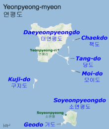
Map of the Yeonpyeong islands and their main population centersKorean name Hangul 연평도 Hanja 延坪島 Revised Romanization Yeonpyeongdo McCune–Reischauer Yŏnpyŏngdo Yeonpyeong Island or Yeonpyeongdo (hanja: 延坪島) (Korean pronunciation: [jʌnpʰjʌŋdo]) is a group of South Korean islands in the Yellow Sea, located about 80 km (50 mi) west of Incheon and 12 km (7.5 mi) south of the coast of Hwanghae Province, North Korea. The main island of the group is Daeyeonpyeongdo ("Big Yeonpyeong Island"), also referred to simply as Yeonpyeong Island, with an area of 7.01 km2 (2.71 sq mi) and a population of around 1,300. The principal population centre is Yeonpyeong-ri, where the island's ferry port is located. The other inhabited island is Soyeonpyeongdo ("Small Yeonpyeong Island") with a small population and an area of 0.24 km2 (0.093 sq mi). Several other small islands comprise the rest of the group.[1]
The island group constitutes Yeonpyeong-myeon, one of the subdivisions of Ongjin County, Incheon, South Korea.
Yeonpyeong Island is renowned for its kumouuri, a specialty spiced crab.[2]
Maritime border disputes
For more details on this topic, see First Battle of Yeonpyeong, Second Battle of Yeonpyeong, and Bombardment of Yeonpyeong.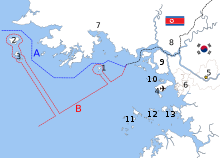 The disputed maritime border between North and South Korea in the West Sea:[3]
A: United Nations-created Northern Limit Line, 1953[4]
B: North Korea-declared "Inter-Korean MDL", 1999[5] The locations of specific islands are reflected in the configuration of each maritime boundary, including- 1–Yeonpyeong Island
- 2–Baengnyeong Island
- 3–Daecheong Island
Other map features4-Jung-gu (Incheon Intl. Airport), 5-Seoul, 6-Incheon, 7-Haeju, 8-Kaesong, 9-Ganghwa County, 10-Bukdo Myeon, 11-Deokjeokdo, 12-Jawol Myeon, 13-Yeongheung MyeonYeonpyeong lies near the Northern Limit Line and is only 12 km (7.5 mi) from the North Korean coastline. The 1953 Armistice Agreement which ended the Korean War specified that the five islands including Yeonpyeong would remain under South Korean control.[6] North Korea subsequently respected the UN-acknowledged western maritime border for many years until around the mid-1990s.[7] However, since the 1990s North Korea has disputed the western maritime border, called the Northern Limit Line (NLL).[7] The North Korean government claims a border farther south that encompasses valuable fishing grounds (though it skirts around South Korean-held islands such as Yeonpyeong). North Korea's claim is not accepted internationally.[8][citation needed]
On November 23, 2010, North Korean artillery shelled Yeonpyeong with dozens of rounds at Yeonpyeong-ri and the surrounding area.[9] This shelling followed a Southern military exercise in the area. The South returned fire with 155mm K-9 self-propelled howitzers.[10] The shelling damaged dozens of houses as well as Southern military infrastructure and set buildings on fire.[11] Two South Korean Marines and two civilians were killed in the shelling, with eighteen others wounded.[12][13][14] Accounts of the billowing smoke were reported in Korean and international newspapers;[15] and thick columns of black smoke rising from the island were the primary proof that the attack had occurred. South Koreans watching television saw the smoke rising from the island after it was hit.[16]
External links
 Media related to Yeonpyeong Island at Wikimedia Commons
References
- ^ "Yeonpyeong Island: A history". Telegraph. http://www.telegraph.co.uk/news/worldnews/asia/southkorea/8155486/Yeonpyeong-Island-A-history.html. Retrieved 2010-11-23.
- ^ Ryoo, Moo Bong. (2009). "The Korean Armistice and the Islands," p. 13 (at PDF-p. 21). Strategy research project at the U.S. Army War College; retrieved 26 Nov 2010.
- ^ "Factbox: What is the Korean Northern Limit Line?" Reuters (UK). November 23, 2010; retrieved 26 Nov 2010.
- ^ Van Dyke, Jon et al. "The North/South Korea Boundary Dispute in the Yellow (West) Sea," Marine Policy 27 (2003), 143-158; note that "Inter-Korean MDL" is cited because it comes from an academic source and the writers were particular enough to include in quotes as we present it. The broader point is that the maritime demarcation line here is NOT a formal extension of the Military Demarcation Line; compare "NLL—Controversial Sea Border Between S.Korea, DPRK, " People's Daily (PRC), November 21, 2002; retrieved 22 Dec 2010
- ^ Armistice Agreement, paragraph 13(b). "Text of the Korean War Armistice Agreement". FindLaw. 1953-07-27. http://news.findlaw.com/wp/docs/korea/kwarmagr072753.html. Retrieved 2010-11-25.
- ^ a b North Korea's reckless attacks cannot be tolerated November 24, 2010. Japanese newspaper Mainichi
- ^ 1. DPRK's claim is neither based on International law nor International Law of the Sea. 2. The United Nations Command insisted that the NLL must be maintained until a new maritime MDL could be established through the United Nations Command Military Armistice Commission on the armistice agreement and DPRK's claim was not established through the UNCMAC.
- ^ ((cite web|url=http://www.washingtontimes.com/news/2010/nov/23/n-korea-fires-artillery-s-korean-island-2-dead/))
- ^ "합참 "우리 군 대응사격으로 북한 측 피해도 상당할 것"". Chosun Ilbo. November 23, 2010. http://news.chosun.com/site/data/html_dir/2010/11/23/2010112301706.html. Retrieved 2010-11-23.
- ^ Kim, Kwang-Tae (November 22, 2010). "SKorea: NKorea Fires Artillery Onto Island". Associated Press. http://abcnews.go.com/International/wireStory?id=12220233. Retrieved 2010-11-22.
- ^ "(URGENT) Four S. Korean soldiers wounded by N. Korean artillery fire: military officials". Yonhap News Agency. November 23, 2010. http://english.yonhapnews.co.kr/news/2010/11/23/0200000000AEN20101123007100315.HTML. Retrieved 2010-11-22.
- ^ Branigan, Tania (2010-11-23). "Artillery fire on Korean border". The Guardian. http://www.guardian.co.uk/world/2010/nov/23/north-korea-south-korea-artillery-fire. Retrieved 2010-11-23.
- ^ "Artillery fire on Korean border". BBC Online. BBC. 2010-11-23. http://www.bbc.co.uk/news/world-asia-pacific-11818005. Retrieved 2010-11-23.
- ^ Park Si-soo. "Yeonpyeong turns into inferno," Korea Times. November 23, 2010.
- ^ "Energy and Environment," Salem Radio News Network, November 23, 2010.
Categories:- Islands of South Korea
- Islands of the Yellow Sea


Wikimedia Foundation. 2010.