- Custer Airport
-
Custer Airport 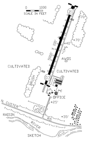
IATA: none – ICAO: KTTF 

Summary Airport type Public Owner City of Monroe Operator Cleveland ARTCC Serves Monroe, Michigan Location 2800 North Custer Road
Monroe, Michigan 48162Elevation AMSL 616 ft / 188 m Coordinates 41°55′59″N 83°26′10″W / 41.933°N 83.436°WCoordinates: 41°55′59″N 83°26′10″W / 41.933°N 83.436°W Runways Direction Length Surface ft m 3L/21R 4,997 1,523 Asphalt Statistics (2009) Aircraft operations 13,068 Based aircraft 37 Source: Federal Aviation Administration[1] Custer Airport (ICAO: KTTF, FAA LID: TTF), sometimes referred to as Monroe Custer Airport, is a city-owned public airport located in the city of Monroe in Monroe County, Michigan. The airport opened in November 1946[1] and was named for George Armstrong Custer, who spent much of his early life in Monroe.
Custer Airport is owned by the city of Monroe and is financially supported through hangar rentals, landing fees, and fuel sales. It is located on North Custer Road (formerly designated as M-130) about two miles (3.2 km) northwest of Monroe's downtown area. The airport property itself — occupying 158 acres (63 ha) — is an exclave of the city limits and is separated by a one-quarter mile (0.4 km) wide undeveloped residential area belonging to Frenchtown Charter Township. Since the city owns the airport, the area it occupies was incorporated into the city limits. Munson Park, the largest public recreation park in Monroe, occupies the land immediately east of the airport. The River Raisin is just south of the airport, and farmland surrounds the airport to the west and north.
Contents
Facilities
 Light beacon, hangar, and tarmac
The airport has one 4997 × 100 feet (1523 × 30 m) asphalt runway (3-21) with a full length taxiway. Both are illuminated with high intensity lighting, runway 21 has runway end identifiers (REILS) and both runways have visual approach slope indicators (VASI). The airport has no regularly scheduled flights or arrivals. As a general aviation airport, it is mainly used by private pilots for personal and business use, as well as a variety of chartered aircraft bringing people in to do business in Monroe County. Custer Airport is able to accommodate a large variety of aircraft, including single engine aircraft, twin engine aircraft, and business jets such as the Cessna Citation and Learjet. The airport has personal hangars that house approximately 45 airplanes and a large hangar that houses several corporate aircraft as well as the Monroe Aviation School of Flight and Monroe Aviation Aircraft Maintenance.[2] In addition, a Michigan Civil Air Patrol aircraft is stationed at the airport. The Monroe County Sheriff Department maintains hangars for its helicopter operations. The airport has 100LL fuel available 24 hours through self-serve as well as full-service Jet-A fuel. In 2007, there was an average of 65 flights per day for a yearly total of 11,389.[1]
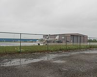 Tarmac and hangar/terminal
The airport operates continuously and is staffed from 8:00 AM–5:00 PM with after-hours services available through prior arrangement. Custer Airport has no control tower, and instrument traffic is handled by the Cleveland Air Route Traffic Control Center (ZOB) in coordination with the Detroit Approach and Departure Control.[3] The nearest neighboring airports that can accommodate flights from Custer Airport are Lenawee County Airport to the west, Toledo Suburban Airport to the southwest, and Grosse Ile Municipal Airport to the north. Detroit Metropolitan Wayne County Airport and Toledo Express Airport are within close proximity and are used regularly by pilots departing Monroe for both business and training purposes.
Following the September 11 attacks in 2001, local concerns were raised that Custer Airport could be shut down by government intervention because of the airport's close proximity to a nuclear power plant. Custer Airport is located approximately 9½ miles (15.3 km) from the Enrico Fermi Nuclear Generating Station in nearby Frenchtown Charter Township. It was suggested that airports within 10 miles of a nuclear power plant be shut down until tighter security policies and government mandates could be enacted by both the airports and nuclear power plants.[4] Custer Airport was not affected, because security was deemed more than adequate.
Accidents
- At around 3:45 in the afternoon of March 29, 2011, a Piper Malibu airplane carrying three male passengers crashed into a soccer field in neighboring Munson Park. The plane departed from Toledo Suburban Airport (located about 15 miles south of Custer Airport in Whiteford Township) earlier that morning and traveled about 300 miles (482 km) southeast to Bedford County Airport in Pennsylvania. The plane soon departed back to Michigan to land at Custer Airport. However, as it approached the airport, witnesses, primarily the St. Mary Catholic Central High School tennis team practicing in the courts 100 yards (91 meters) from the crash site, say the plane circled low and was encountering problems. The plane exploded upon impact with the ground. All three passengers were killed. The cause of the crash is still under investigation.[5][6][7]
References
- ^ a b c FAA Airport Master Record for TTF (Form 5010 PDF), effective 2009-05-07.
- ^ Monroe Aviation. "Monroe Aviation School of Flight". http://www.monroeflight.com/. Retrieved March 11, 2010.
- ^ AirNav.com (07 May 2009). "FAA Information: Custer Airport (KTTF)". http://www.airnav.com/airport/TTF. Retrieved June 11, 2009.
- ^ Stroller, Gary (10 June 2003). "Nuclear plants near airports may be at risk". USA Today. http://www.usatoday.com/money/biztravel/2003-06-10-nuclear_x.htm. Retrieved June 11, 2009.
- ^ Yahoo! News (29 March 2011). "Small plane crash in Southeast Michigan kills three". http://news.yahoo.com/s/nm/20110329/us_nm/us_airplane_crash. Retrieved March 29, 2011.
- ^ WorldNow and WTOL (29 March 2011). "Three people dead after plane crash in Monroe, MI". http://www.wtol.com/Global/story.asp?S=14344067. Retrieved March 29, 2011.
- ^ MSNBC.com (29 March 2011). "3 Killed When Plane Crashes In Monroe Park". http://www.msnbc.msn.com/id/42327411/ns/local_news-detroit_mi/. Retrieved March 29, 2011.
External links
- City of Monroe official website
- Fixed Base Operator website
- Resources for this airport:
- AirNav airport information for KTTF
- ASN accident history for TTF
- FlightAware airport information and live flight tracker
- NOAA/NWS latest weather observations
- SkyVector aeronautical chart, Terminal Procedures for KTTF
Categories:- Airports in Michigan
- Monroe, Michigan
- Airports in Monroe County, Michigan


Wikimedia Foundation. 2010.