Pottinger County

Pottinger County
Pottinger
New South Wales
Pottinger NSW.PNG
Location in New South Wales
Lands administrative divisions around Pottinger
White Nandewar Nandewar
Gowen Pottinger Buckland
Napier Bligh Brisbane

Pottinger County is one of the 141 Cadastral divisions of New South Wales. It is located to the south west of the Namoi River and Mooki River, near Gunnedah.

Pottinger County was named in honour of the first Governor of Hong Kong Sir Henry Pottinger, first Baronet (1789-1856).[1]

Parishes

A full list of parishes found within this county; their current Local Government Areas of Australia (LGA) and mapping coordinates to the approximate centre of each location is as follows:

Parish LGA Coordinates
Baan Baa Narrabri Shire 30°36′54″S 150°01′04″E / 30.615°S 150.01778°E / -30.615; 150.01778 (Baan Baa Parish)
Bando Gunnedah Shire 31°08′54″S 150°00′04″E / 31.14833°S 150.00111°E / -31.14833; 150.00111 (Bando Parish)
Benelabri Gunnedah Shire 30°55′54″S 150°00′04″E / 30.93167°S 150.00111°E / -30.93167; 150.00111 (Benelabri Parish)
Bingle Gunnedah Shire 31°14′54″S 149°51′04″E / 31.24833°S 149.85111°E / -31.24833; 149.85111 (Bingle Parish)
Black Jack Gunnedah Shire 31°02′54″S 150°14′04″E / 31.04833°S 150.23444°E / -31.04833; 150.23444 (Black Jack Parish)
Boggabri Narrabri Shire 30°41′54″S 150°00′04″E / 30.69833°S 150.00111°E / -30.69833; 150.00111 (Boggabri Parish)
Bomera Warrumbungle Shire 31°28′54″S 149°51′04″E / 31.48167°S 149.85111°E / -31.48167; 149.85111 (Bomera Parish)
Breeza Gunnedah Shire 31°13′54″S 150°24′04″E / 31.23167°S 150.40111°E / -31.23167; 150.40111 (Breeza Parish)
Brennan Warrumbungle Shire 31°40′54″S 149°54′04″E / 31.68167°S 149.90111°E / -31.68167; 149.90111 (Brennan Parish)
Brigalow Warrumbungle Shire 30°59′54″S 149°45′04″E / 30.99833°S 149.75111°E / -30.99833; 149.75111 (Brigalow Parish)
Brothers Gunnedah Shire 31°14′54″S 150°11′04″E / 31.24833°S 150.18444°E / -31.24833; 150.18444 (Brothers Parish)
Brown Gunnedah Shire 31°11′54″S 150°12′04″E / 31.19833°S 150.20111°E / -31.19833; 150.20111 (Brown Parish)
Bulga Warrumbungle Shire 31°14′54″S 149°42′04″E / 31.24833°S 149.70111°E / -31.24833; 149.70111 (Bulga Parish)
Bundella Liverpool Plains Shire 31°38′54″S 149°57′04″E / 31.64833°S 149.95111°E / -31.64833; 149.95111 (Bundella Parish)
Calala Gunnedah Shire 31°14′54″S 150°03′04″E / 31.24833°S 150.05111°E / -31.24833; 150.05111 (Calala Parish)
Clarke Warrumbungle Shire 31°34′54″S 149°51′04″E / 31.58167°S 149.85111°E / -31.58167; 149.85111 (Clarke Parish)
Clift Gunnedah Shire 31°17′54″S 150°21′04″E / 31.29833°S 150.35111°E / -31.29833; 150.35111 (Clift Parish)
Coogal Warrumbungle Shire 31°00′54″S 149°52′04″E / 31.015°S 149.86778°E / -31.015; 149.86778 (Coogal Parish)
Coolanbilla Liverpool Plains Shire 31°24′54″S 150°08′04″E / 31.415°S 150.13444°E / -31.415; 150.13444 (Coolanbilla Parish)
Coomoo Coomoo Liverpool Plains Shire 31°39′54″S 150°08′04″E / 31.665°S 150.13444°E / -31.665; 150.13444 (Coomoo Coomoo Parish)
Curlewis Gunnedah Shire 31°08′54″S 151°20′04″E / 31.14833°S 151.33444°E / -31.14833; 151.33444 (Curlewis Parish)
Denison West Narrabri Shire 30°52′54″S 149°43′04″E / 30.88167°S 149.71778°E / -30.88167; 149.71778 (Denison West Parish)
Denison Gunnedah Shire 30°52′54″S 149°52′04″E / 30.88167°S 149.86778°E / -30.88167; 149.86778 (Denison Parish)
Digby Gunnedah Shire 31°07′54″S 150°12′04″E / 31.13167°S 150.20111°E / -31.13167; 150.20111 (Digby Parish)
Doona Gunnedah Shire 31°20′54″S 150°20′04″E / 31.34833°S 150.33444°E / -31.34833; 150.33444 (Doona Parish)
Dubbleda Gunnedah Shire 30°50′54″S 150°06′04″E / 30.84833°S 150.10111°E / -30.84833; 150.10111 (Dubbleda Parish)
Garrawilla Warrumbungle Shire 31°07′54″S 149°40′04″E / 31.13167°S 149.66778°E / -31.13167; 149.66778 (Garrawilla Parish)
Ghoolendaadi Gunnedah Shire 30°50′54″S 149°59′04″E / 30.84833°S 149.98444°E / -30.84833; 149.98444 (Ghoolendaadi Parish)
Gill Gunnedah Shire 31°01′54″S 150°08′04″E / 31.03167°S 150.13444°E / -31.03167; 150.13444 (Gill Parish)
Goally Warrumbungle Shire 31°06′54″S 149°49′04″E / 31.115°S 149.81778°E / -31.115; 149.81778 (Goally Parish)
Goragilla Warrumbungle Shire 31°16′54″S 149°40′04″E / 31.28167°S 149.66778°E / -31.28167; 149.66778 (Goragilla Parish)
Goran Gunnedah Shire 31°11′54″S 150°04′04″E / 31.19833°S 150.06778°E / -31.19833; 150.06778 (Goran Parish)
Gulligal Narrabri Shire 30°44′54″S 150°02′04″E / 30.74833°S 150.03444°E / -30.74833; 150.03444 (Gulligal Parish)
Gunnedah Gunnedah Shire 30°59′54″S 150°10′04″E / 30.99833°S 150.16778°E / -30.99833; 150.16778 (Gunnedah Parish)
Howes Hill Liverpool Plains Shire 31°14′54″S 150°08′04″E / 31.24833°S 150.13444°E / -31.24833; 150.13444 (Howes Hill Parish)
Johnston Gunnedah Shire 31°04′54″S 150°20′04″E / 31.08167°S 150.33444°E / -31.08167; 150.33444 (Johnston Parish)
Kickerbell Liverpool Plains Shire 31°29′54″S 150°21′04″E / 31.49833°S 150.35111°E / -31.49833; 150.35111 (Kickerbell Parish)
Lawson Liverpool Plains Shire 31°32′54″S 150°00′04″E / 31.54833°S 150.00111°E / -31.54833; 150.00111 (Lawson Parish)
Melville Gunnedah Shire 30°59′54″S 150°00′04″E / 30.99833°S 150.00111°E / -30.99833; 150.00111 (Melville Parish)
Mema Liverpool Plains Shire 31°29′54″S 150°05′04″E / 31.49833°S 150.08444°E / -31.49833; 150.08444 (Mema Parish)
Merrigula Gunnedah Shire 31°16′54″S 149°55′04″E / 31.28167°S 149.91778°E / -31.28167; 149.91778 (Merrigula Parish)
Millie Gunnedah Shire 30°57′54″S 150°04′04″E / 30.965°S 150.06778°E / -30.965; 150.06778 (Millie Parish)
Moredevil Liverpool Plains Shire 32°38′54″S 150°04′04″E / 32.64833°S 150.06778°E / -32.64833; 150.06778 (Moredevil Parish)
Mucca Mucca Warrumbungle Shire 31°15′54″S 149°36′04″E / 31.265°S 149.60111°E / -31.265; 149.60111 (Mucca Mucca Parish)
Nea Gunnedah Shire 31°13′54″S 150°17′04″E / 31.23167°S 150.28444°E / -31.23167; 150.28444 (Nea Parish)
Nombi Warrumbungle Shire 31°10′54″S 149°46′04″E / 31.18167°S 149.76778°E / -31.18167; 149.76778 (Nombi Parish)
Premer Warrumbungle Shire 31°25′54″S 149°55′04″E / 31.43167°S 149.91778°E / -31.43167; 149.91778 (Premer Parish)
Pringle Liverpool Plains Shire 31°32′54″S 150°04′04″E / 31.54833°S 150.06778°E / -31.54833; 150.06778 (Pringle Parish)
Rodd Liverpool Plains Shire 31°29′54″S 150°12′04″E / 31.49833°S 150.20111°E / -31.49833; 150.20111 (Rodd Parish)
Saltwater Warrumbungle Shire 31°27′54″S 149°47′04″E / 31.465°S 149.78444°E / -31.465; 149.78444 (Saltwater Parish)
Springfield Liverpool Plains Shire 31°25′54″S 150°14′04″E / 31.43167°S 150.23444°E / -31.43167; 150.23444 (Springfield Parish)
Tamarang Liverpool Plains Shire 31°20′54″S 149°57′04″E / 31.34833°S 149.95111°E / -31.34833; 149.95111 (Tamarang Parish)
Tambar Warrumbungle Shire 31°22′54″S 149°51′04″E / 31.38167°S 149.85111°E / -31.38167; 149.85111 (Tambar Parish)
Tinkrameanah Warrumbungle Shire 31°20′54″S 149°39′04″E / 31.34833°S 149.65111°E / -31.34833; 149.65111 (Tinkrameanah Parish)
Trinkey Liverpool Plains Shire 31°24′54″S 150°03′04″E / 31.415°S 150.05111°E / -31.415; 150.05111 (Trinkey Parish)
Tulla Mullen Narrabri Shire 30°37′54″S 149°55′04″E / 30.63167°S 149.91778°E / -30.63167; 149.91778 (Tulla Mullen Parish)
Urangera Warrumbungle Shire 31°16′54″S 149°47′04″E / 31.28167°S 149.78444°E / -31.28167; 149.78444 (Urangera Parish)
Walla Walla West Narrabri Shire 30°45′54″S 149°49′04″E / 30.765°S 149.81778°E / -30.765; 149.81778 (Walla Walla West Parish)
Walla Walla Narrabri Shire 30°45′54″S 149°55′04″E / 30.765°S 149.91778°E / -30.765; 149.91778 (Walla Walla Parish)
Weston Liverpool Plains Shire 31°26′54″S 150°23′04″E / 31.44833°S 150.38444°E / -31.44833; 150.38444 (Weston Parish)
Willala Narrabri Shire 30°41′54″S 149°54′04″E / 30.69833°S 149.90111°E / -30.69833; 149.90111 (Willala Parish)
Wilson Warrumbungle Shire 31°22′54″S 149°44′04″E / 31.38167°S 149.73444°E / -31.38167; 149.73444 (Wilson Parish)
Wondoba Gunnedah Shire 31°06′54″S 150°05′04″E / 31.115°S 150.08444°E / -31.115; 150.08444 (Wondoba Parish)
Yarraman Liverpool Plains Shire 31°37′54″S 150°12′04″E / 31.63167°S 150.20111°E / -31.63167; 150.20111 (Yarraman Parish)

References

  1. ^ Geographical Names Board of NSW

Wikimedia Foundation. 2010.

Игры ⚽ Нужно решить контрольную?

Look at other dictionaries:

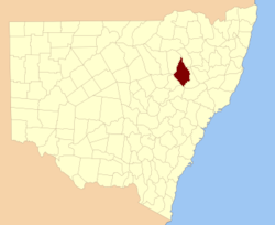
  • Pottinger County, New South Wales — Infobox Australian cadastral name = Pottinger state = New South Wales caption = Location in New South Wales near nw = White near n = Nandewar near ne = Nandewar near e = Buckland near se = Brisbane near s = Bligh near sw = Napier near w =… …   Wikipedia

  • Pottinger — may refer to:* Belfast Pottinger (Northern Ireland Parliament constituency) * Belfast Pottinger (UK Parliament constituency) (1918 1922) * Bell Pottinger Group * Pottinger (Australia), an Australian M A advisory company * Pottinger… …   Wikipedia

  • Pottinger (District Electoral Area) — Pottinger District Electoral Area Map showing Pottinger wards within Belfast Area  6.17 km2 (2.38 sq mi) Population 31,2 …   Wikipedia

  • Henry Eldred Curwen Pottinger — Infobox Governor name=Sir Henry Eldred Curwen Pottinger width=180px height=220px caption= order=1st office=Governor of Hong Kong term start=26 June 1843 term end=8 May 1844 lieutenant= predecessor= (none) successor=Sir John Francis Davis birth… …   Wikipedia

  • Buckland County, New South Wales — Infobox Australian cadastral name = Buckland state = New South Wales caption = Location in New South Wales near nw = Pottinger near n = Nandewar near ne = Darling near e = Parry near se = Brisbane near s = Brisbane near sw = Bligh near w =… …   Wikipedia

  • Buckland County — Map of all coordinates from Google Map of all coordinates from Bing Export all coordinates as KML …   Wikipedia

  • White County, New South Wales — Infobox Australian cadastral name = White state = New South Wales caption = Location in New South Wales near nw = Jamison near n = Jamison near ne = Nandewar near e = Pottinger near se = Pottinger near s = Napier near sw = Gowen near w =… …   Wikipedia

  • Crosby Township, Hamilton County, Ohio — Crosby Township, Ohio   Township   Municipalities and townships of Hamilton County …   Wikipedia

  • Brisbane County, New South Wales — Infobox Australian cadastral name = Brisbane state = New South Wales caption = Location in New South Wales near nw = Pottinger near n = Buckland near ne = Parry near e = Hawes near se = Durham near s = Hunter near sw = Phillip near w =… …   Wikipedia

  • Bligh County, New South Wales — Infobox Australian cadastral name = Bligh state = New South Wales caption = Location in New South Wales near nw = Napier near n = Pottinger near ne = Buckland near e = Brisbane near se = Phillip near s = Wellington near sw = Gordon near w =… …   Wikipedia

Share the article and excerpts

Direct link
Do a right-click on the link above
and select “Copy Link”