Nandewar County

Nandewar County
Nandewar
New South Wales
Nandewar NSW.PNG
Location in New South Wales
Lands administrative divisions around Nandewar
Jamison Courallie Murchison
White Nandewar Darling
Pottinger Buckland Parry

Nandewar County is one of the 141 Cadastral divisions of New South Wales. It is located to the east of the Namoi River, with Narrabri at the north-west edge, and Gunnedah at the southern edge.

Nandewar County is named after the range of mountains called Nandewar by the local Aboriginals.[1]

Parishes

A full list of parishes found within this county; their current LGA and mapping coordinates to the approximate centre of each location is as follows:

Parish LGA Coordinates
Berrioye Narrabri Shire 30°30′54″S 150°14′04″E / 30.515°S 150.23444°E / -30.515; 150.23444 (Berrioye Parish)
Billyena Narrabri Shire 30°28′54″S 150°08′04″E / 30.48167°S 150.13444°E / -30.48167; 150.13444 (Billyena Parish)
Boggabri Narrabri Shire 30°39′49″S 150°07′06″E / 30.66361°S 150.11833°E / -30.66361; 150.11833 (Boggabri Parish)
Bollol Narrabri Shire 30°35′54″S 150°17′04″E / 30.59833°S 150.28444°E / -30.59833; 150.28444 (Bollol Parish)
Boorobil Gunnedah Shire 30°56′54″S 150°24′04″E / 30.94833°S 150.40111°E / -30.94833; 150.40111 (Boorobil Parish)
Brentry Gunnedah Shire 30°46′54″S 150°12′04″E / 30.78167°S 150.20111°E / -30.78167; 150.20111 (Brentry Parish)
Bullawa Narrabri Shire 30°17′54″S 149°59′04″E / 30.29833°S 149.98444°E / -30.29833; 149.98444 (Bullawa Parish)
Burburgate Gunnedah Shire 30°54′24″S 150°14′04″E / 30.90667°S 150.23444°E / -30.90667; 150.23444 (Burburgate Parish)
Byar Narrabri Shire 30°25′54″S 150°14′04″E / 30.43167°S 150.23444°E / -30.43167; 150.23444 (Byar Parish)
Connor Narrabri Shire 30°30′54″S 150°20′04″E / 30.515°S 150.33444°E / -30.515; 150.33444 (Connor Parish)
Coryah Narrabri Shire 30°11′54″S 150°04′04″E / 30.19833°S 150.06778°E / -30.19833; 150.06778 (Coryah Parish)
Deriah Narrabri Shire 30°21′54″S 150°04′04″E / 30.365°S 150.06778°E / -30.365; 150.06778 (Deriah Parish)
Durrisdeer Narrabri Shire 30°29′54″S 150°00′04″E / 30.49833°S 150.00111°E / -30.49833; 150.00111 (Durrisdeer Parish)
Eulah Narrabri Shire 30°21′54″S 150°00′04″E / 30.365°S 150.00111°E / -30.365; 150.00111 (Eulah Parish)
Gunnenbeme Gunnedah Shire 30°52′54″S 150°25′04″E / 30.88167°S 150.41778°E / -30.88167; 150.41778 (Gunnenbeme Parish)
Killarney Narrabri Shire 30°14′54″S 149°59′04″E / 30.24833°S 149.98444°E / -30.24833; 149.98444 (Killarney Parish)
Leard Narrabri Shire 30°34′54″S 150°08′04″E / 30.58167°S 150.13444°E / -30.58167; 150.13444 (Leard Parish)
Lindesay Gwydir Shire 30°29′54″S 150°18′04″E / 30.49833°S 150.30111°E / -30.49833; 150.30111 (Lindesay Parish)
Mihi Narrabri Shire 30°35′54″S 150°22′04″E / 30.59833°S 150.36778°E / -30.59833; 150.36778 (Mihi Parish)
Moonbill Narrabri Shire 30°12′54″S 149°56′04″E / 30.215°S 149.93444°E / -30.215; 149.93444 (Moonbill Parish)
Narrabri Narrabri Shire 30°14′54″S 149°49′04″E / 30.24833°S 149.81778°E / -30.24833; 149.81778 (Narrabri Parish)
Ningadhun Narrabri Shire 30°14′54″S 150°07′04″E / 30.24833°S 150.11778°E / -30.24833; 150.11778 (Ningadhun Parish)
Rangira Gunnedah Shire 30°36′54″S 150°25′04″E / 30.615°S 150.41778°E / -30.615; 150.41778 (Rangira Parish)
Rusden Narrabri Shire 30°20′54″S 150°11′04″E / 30.34833°S 150.18444°E / -30.34833; 150.18444 (Rusden Parish)
Therribri Narrabri Shire 30°32′54″S 150°04′04″E / 30.54833°S 150.06778°E / -30.54833; 150.06778 (Therribri Parish)
Tippereena Narrabri Shire 30°20′54″S 149°53′04″E / 30.34833°S 149.88444°E / -30.34833; 149.88444 (Tippereena Parish)
Tulcumba Gunnedah Shire 30°44′54″S 150°20′04″E / 30.74833°S 150.33444°E / -30.74833; 150.33444 (Tulcumba Parish)
Vickery Narrabri Shire 30°43′54″S 150°14′04″E / 30.73167°S 150.23444°E / -30.73167; 150.23444 (Vickery Parish)
Wallah Narrabri Shire 30°26′54″S 149°58′04″E / 30.44833°S 149.96778°E / -30.44833; 149.96778 (Wallah Parish)
Wean Narrabri Shire 30°39′54″S 150°14′04″E / 30.665°S 150.23444°E / -30.665; 150.23444 (Wean Parish)
Weetaliba Gunnedah Shire 30°54′54″S 150°18′04″E / 30.915°S 150.30111°E / -30.915; 150.30111 (Weetaliba Parish)
Willuri Gunnedah Shire 30°42′54″S 150°23′04″E / 30.715°S 150.38444°E / -30.715; 150.38444 (Willuri Parish)
Yarrari Gunnedah Shire 30°49′54″S 150°22′04″E / 30.83167°S 150.36778°E / -30.83167; 150.36778 (Yarrari Parish)

References

  1. ^ Geographical Names Board of NSW

Wikimedia Foundation. 2010.

Игры ⚽ Нужен реферат?

Look at other dictionaries:

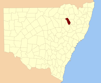
  • Nandewar County, New South Wales — Infobox Australian cadastral name = Nandewar state = New South Wales caption = Location in New South Wales near nw = Jamison near n = Courallie near ne = Murchison near e = Darling near se = Parry near s = Buckland near sw = Pottinger near w =… …   Wikipedia

  • Darling County — Map of all coordinates from Google Map of all coordinates from Bing Export all coordinates as KML …   Wikipedia

  • Pottinger County, New South Wales — Infobox Australian cadastral name = Pottinger state = New South Wales caption = Location in New South Wales near nw = White near n = Nandewar near ne = Nandewar near e = Buckland near se = Brisbane near s = Bligh near sw = Napier near w =… …   Wikipedia

  • Pottinger County — Map of all coordinates from Google Map of all coordinates from Bing Export all coordinates as KML …   Wikipedia

  • Buckland County, New South Wales — Infobox Australian cadastral name = Buckland state = New South Wales caption = Location in New South Wales near nw = Pottinger near n = Nandewar near ne = Darling near e = Parry near se = Brisbane near s = Brisbane near sw = Bligh near w =… …   Wikipedia

  • Buckland County — Map of all coordinates from Google Map of all coordinates from Bing Export all coordinates as KML …   Wikipedia

  • Parry County, New South Wales — Infobox Australian cadastral name = Parry state = New South Wales caption = Location in New South Wales near nw = Nandewar near n = Inglis near ne = Vernon near e = Vernon near se = Hawes near s = Brisbane near sw = Buckland near w =… …   Wikipedia

  • Parry County — Map of all coordinates from Google Map of all coordinates from Bing Export all coordinates as KML …   Wikipedia

  • Darling County, New South Wales — Infobox Australian cadastral name = Darling state = New South Wales caption = Location in New South Wales near nw = Murchison near n = Murchison near ne = Hardinge near e = Hardinge near se = Inglis near s = Parry near sw = Buckland near w =… …   Wikipedia

  • Jamison County, New South Wales — Infobox Australian cadastral name = Jamison state = New South Wales caption = Location in New South Wales near nw = Benarba near n = Benarba near ne = Courallie near e = Murchison near se = Nandewar near s = White near sw = Baradine near w =… …   Wikipedia

Share the article and excerpts

Direct link
Do a right-click on the link above
and select “Copy Link”