Buckland County

Buckland County
Buckland
New South Wales
Buckland NSW.PNG
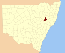
Location in New South Wales
Lands administrative divisions around Buckland
Pottinger Nandewar Darling
Pottinger Buckland Parry
Bligh Brisbane Brisbane

Buckland County is one of the 141 Cadastral divisions of New South Wales. It is situated between a small part of the Namoi River in the north to the Liverpool Range in the south. The Mooki River is the boundary to the west. It includes Quirindi.

Buckland County was proclaimed as a county on December 30, 1848 as one of 15 counties then proclaimed Description:-'County of Buckland, containing about 1,484 square miles (3,840 km2). Whilst no official record of naming of the county has been found and there can be no certainty as to the person after whom it was named it is considered possible that the county was named in honour of the Reverend Dr. Buckland.[1]

Parishes within this county

A full list of parishes found within this county; their current LGA and mapping coordinates to the approximate centre of each location is as follows:

Parish LGA Coordinates
Babbinboon Gunnedah Shire Council 31°02′54″S 150°33′04″E / 31.04833°S 150.55111°E / -31.04833; 150.55111 (Babbinboon)
Borambil Liverpool Plains Shire Council 31°18′54″S 150°36′04″E / 31.315°S 150.60111°E / -31.315; 150.60111 (Borambil)
Carroll Gunnedah Shire Council 30°59′54″S 150°29′04″E / 30.99833°S 150.48444°E / -30.99833; 150.48444 (Carroll)
Clift Tamworth Regional Council 31°17′54″S 150°37′04″E / 31.29833°S 150.61778°E / -31.29833; 150.61778 (Clift)
Coeypolly Liverpool Plains Shire Council 31°25′54″S 150°46′04″E / 31.43167°S 150.76778°E / -31.43167; 150.76778 (Coeypolly)
Cooridoon Gunnedah Shire Council 30°59′54″S 150°20′04″E / 30.99833°S 150.33444°E / -30.99833; 150.33444 (Cooridoon)
Currabubula Tamworth Regional Council 31°16′54″S 150°43′04″E / 31.28167°S 150.71778°E / -31.28167; 150.71778 (Currabubula)
Denver Gunnedah Shire Council 31°10′54″S 150°30′04″E / 31.18167°S 150.50111°E / -31.18167; 150.50111 (Denver)
Dight Gunnedah Shire Council 31°03′54″S 150°27′04″E / 31.065°S 150.45111°E / -31.065; 150.45111 (Dight)
Evan Liverpool Plains Shire Council 31°21′54″S 150°48′04″E / 31.365°S 150.80111°E / -31.365; 150.80111 (Evan)
Ferrier Gunnedah Shire Council 31°18′54″S 150°31′04″E / 31.315°S 150.51778°E / -31.315; 150.51778 (Ferrier)
Gregson Liverpool Plains Shire Council 31°43′54″S 150°37′04″E / 31.73167°S 150.61778°E / -31.73167; 150.61778 (Gregson)
Grenfell Tamworth Regional Council 31°23′54″S 150°36′04″E / 31.39833°S 150.60111°E / -31.39833; 150.60111 (Grenfell)
Gunnadilly Liverpool Plains Shire Council 31°27′54″S 150°31′04″E / 31.465°S 150.51778°E / -31.465; 150.51778 (Gunnadilly)
Hudson Liverpool Plains Shire Council 31°41′54″S 150°20′04″E / 31.69833°S 150.33444°E / -31.69833; 150.33444 (Hudson)
Loder Liverpool Plains Shire Council 31°36′54″S 150°52′04″E / 31.615°S 150.86778°E / -31.615; 150.86778 (Loder)
Moan Liverpool Plains Shire Council 31°42′54″S 150°12′04″E / 31.715°S 150.20111°E / -31.715; 150.20111 (Moan)
Mooki Gunnedah Shire Council 31°12′54″S 150°29′04″E / 31.215°S 150.48444°E / -31.215; 150.48444 (Mooki)
Parnell Liverpool Plains Shire Council 31°29′54″S 150°54′04″E / 31.49833°S 150.90111°E / -31.49833; 150.90111 (Parnell)
Parsons Hill Liverpool Plains Shire Council 31°36′54″S 150°30′04″E / 31.615°S 150.50111°E / -31.615; 150.50111 (Parsons Hill)
Piallaway Tamworth Regional Council 31°09′54″S 150°38′04″E / 31.165°S 150.63444°E / -31.165; 150.63444 (Piallaway)
Quirindi Liverpool Plains Shire Council 31°29′54″S 150°43′04″E / 31.49833°S 150.71778°E / -31.49833; 150.71778 (Quirindi)
Telford Liverpool Plains Shire Council 31°32′54″S 150°25′04″E / 31.54833°S 150.41778°E / -31.54833; 150.41778 (Telford)
Temi Liverpool Plains Shire Council 31°41′54″S 150°49′04″E / 31.69833°S 150.81778°E / -31.69833; 150.81778 (Temi)
Texas Gunnedah Shire Council 31°08′54″S 150°28′04″E / 31.14833°S 150.46778°E / -31.14833; 150.46778 (Texas)
Towarri Liverpool Plains Shire Council 31°49′54″S 150°37′04″E / 31.83167°S 150.61778°E / -31.83167; 150.61778 (Towarri)
Wallabadah Liverpool Plains Shire Council 31°28′54″S 150°48′04″E / 31.48167°S 150.80111°E / -31.48167; 150.80111 (Wallabadah)
Wallala Gunnedah Shire Council 31°22′54″S 150°29′04″E / 31.38167°S 150.48444°E / -31.38167; 150.48444 (Wallala)
Warrah Liverpool Plains Shire Council 31°33′54″S 150°37′04″E / 31.565°S 150.61778°E / -31.565; 150.61778 (Warrah)
Werrie Tamworth Regional Council 31°19′54″S 150°42′04″E / 31.33167°S 150.70111°E / -31.33167; 150.70111 (Werrie)
Willow Tree Liverpool Plains Shire Council 31°39′54″S 150°44′04″E / 31.665°S 150.73444°E / -31.665; 150.73444 (Willow Tree)
Windy Liverpool Plains Shire Council 31°35′54″S 150°21′04″E / 31.59833°S 150.35111°E / -31.59833; 150.35111 (Windy)
Yarrimanbah Liverpool Plains Shire Council 31°47′54″S 150°26′04″E / 31.79833°S 150.43444°E / -31.79833; 150.43444 (Yarrimanbah)

References


Wikimedia Foundation. 2010.

Игры ⚽ Поможем сделать НИР

Look at other dictionaries:

  • Buckland County, New South Wales — Infobox Australian cadastral name = Buckland state = New South Wales caption = Location in New South Wales near nw = Pottinger near n = Nandewar near ne = Darling near e = Parry near se = Brisbane near s = Brisbane near sw = Bligh near w =… …   Wikipedia

  • Buckland Priory — Monastery information Order Augustinian Established c. 1167 Disestablished 1539 People Founder(s) William de Erleig …   Wikipedia

  • Buckland, Oxfordshire — Buckland is a village and civil parish in the Vale of White Horse district of the English county of Oxfordshire, and historically in Berkshire.Character and locationAccording to the 2001 census, the parish had a population of 553 inhabitantscite… …   Wikipedia

  • Buckland House — is a large Georgian stately home and the manor house of Buckland in the English county of Oxfordshire (formerly in Berkshire). It is a masterpiece of Palladian architecture erected by John Wood, the Younger for Sir Robert Throckmorton in… …   Wikipedia

  • Buckland, Virginia — Buckland is an unincorporated village in Prince William County, Virginia. Established in 1798, Buckland was an early inland stagecoach town, situated along the Fauquier and Alexandria Turnpike. Buckland is the current site of the Buckland… …   Wikipedia

  • Buckland, Portsmouth — Buckland is a residential area of the city of Portsmouth in the English county of Hampshire.Buckland, then known as Bocheland, was one of the three settlements on Portsea Island mentioned in the Domesday Book. The Manor of Bocheland was purchased …   Wikipedia

  • Buckland Newton (hundred) — Buckland Newton Hundred was a hundred in the county of Dorset, England, containing the following parishes:*Buckland Newton *Glanvilles Wootton *Mappowder *Pulham (part): See also: List of hundreds in Dorset …   Wikipedia

  • County Center, Virginia — County Center   CDP   …   Wikipedia

  • Buckland, Massachusetts — Infobox Settlement official name = Buckland, Massachusetts nickname = motto = imagesize = image caption = Buckland Town Hall image mapsize = 250px map caption = Location in Franklin County in Massachusetts mapsize1 = map caption1 = subdivision… …   Wikipedia

  • Buckland, Ohio — Infobox Settlement official name = Buckland, Ohio settlement type = Village nickname = motto = imagesize = image caption = image mapsize = 250x200px map caption = Location of Buckland, Ohio mapsize1 = map caption1 = subdivision type = Country… …   Wikipedia

Share the article and excerpts

Direct link
Do a right-click on the link above
and select “Copy Link”