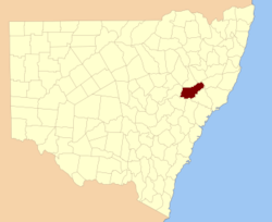
Brisbane County

Brisbane County
Brisbane
New South Wales
Brisbane NSW.PNG
Location in New South Wales
Lands administrative divisions around Brisbane
Pottinger Buckland Parry
Bligh Brisbane Hawes
Phillip Hunter Durham

Brisbane County was one of the original Nineteen Counties in New South Wales and is now one of the 141 Cadastral divisions of New South Wales. It includes Scone, Merriwa and Murrurundi. The Goulburn River is the boundary to the south and the Hunter River the boundary to the south-east. The Liverpool Range area is the boundary to the north, and the Krui River the boundary to the west.

Brisbane County was named in honour of Sir Thomas Makdougall Brisbane Governor (1773-1860).[1] The Electoral district of Phillip, Brisbane and Bligh was the first electoral district for the area, between 1856 and 1859.

Parishes within this county

A full list of parishes found within this county; their current LGA and mapping coordinates to the approximate centre of each location is as follows:

Parish LGA Coordinates
Ailsa Upper Hunter Shire 32°03′54″S 150°11′04″E / 32.065°S 150.18444°E / -32.065; 150.18444 (Ailsa Parish)
Alma Upper Hunter Shire 32°02′54″S 150°59′04″E / 32.04833°S 150.98444°E / -32.04833; 150.98444 (Alma Parish)
Boggibri Upper Hunter Shire 32°02′54″S 150°16′04″E / 32.04833°S 150.26778°E / -32.04833; 150.26778 (Boggibri Parish)
Brawboy Upper Hunter Shire 32°01′54″S 150°41′04″E / 32.03167°S 150.68444°E / -32.03167; 150.68444 (Brawboy Parish)
Brogheda Muswellbrook Shire 32°11′54″S 150°43′04″E / 32.19833°S 150.71778°E / -32.19833; 150.71778 (Brogheda Parish)
Campbell Upper Hunter Shire 32°17′54″S 150°18′04″E / 32.29833°S 150.30111°E / -32.29833; 150.30111 (Campbell Parish)
Castle Sempill Upper Hunter Shire 31°51′54″S 151°13′04″E / 31.865°S 151.21778°E / -31.865; 151.21778 (Castle Sempill Parish)
Cherson Upper Hunter Shire 31°55′54″S 151°07′04″E / 31.93167°S 151.11778°E / -31.93167; 151.11778 (Cherson Parish)
Clanricard Muswellbrook Shire 32°14′54″S 150°45′04″E / 32.24833°S 150.75111°E / -32.24833; 150.75111 (Clanricard Parish)
Coulson Upper Hunter Shire 31°58′54″S 150°24′04″E / 31.98167°S 150.40111°E / -31.98167; 150.40111 (Coulson Parish)
Cranbourne Upper Hunter Shire 32°00′54″S 150°19′04″E / 32.015°S 150.31778°E / -32.015; 150.31778 (Cranbourne Parish)
Crawney Upper Hunter Shire 31°44′54″S 151°08′04″E / 31.74833°S 151.13444°E / -31.74833; 151.13444 (Crawney Parish)
Dangar Muswellbrook Shire 32°21′54″S 150°27′04″E / 32.365°S 150.45111°E / -32.365; 150.45111 (Dangar Parish)
Denman Muswellbrook Shire 32°21′54″S 150°40′04″E / 32.365°S 150.66778°E / -32.365; 150.66778 (Denman Parish)
Ellerston Upper Hunter Shire 31°45′54″S 151°13′04″E / 31.765°S 151.21778°E / -31.765; 151.21778 (Ellerston Parish)
Ellis Muswellbrook Shire 32°12′54″S 150°50′04″E / 32.215°S 150.83444°E / -32.215; 150.83444 (Ellis Parish)
Goulburn Upper Hunter Shire 32°19′54″S 150°23′04″E / 32.33167°S 150.38444°E / -32.33167; 150.38444 (Goulburn Parish)
Guan Gua Upper Hunter Shire 32°05′54″S 150°41′04″E / 32.09833°S 150.68444°E / -32.09833; 150.68444 (Guan Gua Parish)
Gundy Gundy Upper Hunter Shire 32°00′54″S 150°58′04″E / 32.015°S 150.96778°E / -32.015; 150.96778 (Gundy Gundy Parish)
Hall Upper Hunter Shire 32°10′54″S 150°32′04″E / 32.18167°S 150.53444°E / -32.18167; 150.53444 (Hall Parish)
Halscot Upper Hunter Shire 32°08′54″S 150°47′04″E / 32.14833°S 150.78444°E / -32.14833; 150.78444 (Halscot Parish)
Howard Upper Hunter Shire 32°06′54″S 150°19′04″E / 32.115°S 150.31778°E / -32.115; 150.31778 (Howard Parish)
Isis Upper Hunter Shire 31°49′54″S 151°01′04″E / 31.83167°S 151.01778°E / -31.83167; 151.01778 (Isis Parish)
Killoe Upper Hunter Shire 32°06′54″S 150°10′04″E / 32.115°S 150.16778°E / -32.115; 150.16778 (Killoe Parish)
Lincoln Upper Hunter Shire 31°39′54″S 151°03′04″E / 31.665°S 151.05111°E / -31.665; 151.05111 (Lincoln Parish)
Mackenzie Upper Hunter Shire 32°15′54″S 150°22′04″E / 32.265°S 150.36778°E / -32.265; 150.36778 (Mackenzie Parish)
Macqueen Upper Hunter Shire 32°07′54″S 150°57′04″E / 32.13167°S 150.95111°E / -32.13167; 150.95111 (Macqueen Parish)
Manbus Upper Hunter Shire 32°01′54″S 150°46′04″E / 32.03167°S 150.76778°E / -32.03167; 150.76778 (Manbus Parish)
Manobalai Muswellbrook Shire 32°11′54″S 150°36′04″E / 32.19833°S 150.60111°E / -32.19833; 150.60111 (Manobalai Parish)
Melbourne Upper Hunter Shire 31°59′54″S 150°49′04″E / 31.99833°S 150.81778°E / -31.99833; 150.81778 (Melbourne Parish)
Merriwa Upper Hunter Shire 32°09′54″S 150°24′04″E / 32.165°S 150.40111°E / -32.165; 150.40111 (Merriwa Parish)
Murrurundi Upper Hunter Shire 31°45′54″S 150°48′04″E / 31.765°S 150.80111°E / -31.765; 150.80111 (Murrurundi Parish)
Murulla Upper Hunter Shire 31°47′54″S 150°55′04″E / 31.79833°S 150.91778°E / -31.79833; 150.91778 (Murulla Parish)
Myrabluan Upper Hunter Shire 32°07′54″S 150°35′04″E / 32.13167°S 150.58444°E / -32.13167; 150.58444 (Myrabluan Parish)
Nerobingabla Upper Hunter Shire 31°55′54″S 150°36′04″E / 31.93167°S 150.60111°E / -31.93167; 150.60111 (Nerobingabla Parish)
Oxley Upper Hunter Shire 31°55′49″S 150°19′35″E / 31.93028°S 150.32639°E / -31.93028; 150.32639 (Oxley Parish)
Page Upper Hunter Shire 31°54′54″S 150°58′04″E / 31.915°S 150.96778°E / -31.915; 150.96778 (Page Parish)
Park Upper Hunter Shire 32°00′54″S 150°53′04″E / 32.015°S 150.88444°E / -32.015; 150.88444 (Park Parish)
Scone Upper Hunter Shire 32°02′54″S 150°50′04″E / 32.04833°S 150.83444°E / -32.04833; 150.83444 (Scone Parish)
Strathearn Upper Hunter Shire 32°08′54″S 150°51′04″E / 32.14833°S 150.85111°E / -32.14833; 150.85111 (Strathearn Parish)
Temi Upper Hunter Shire 31°41′54″S 150°55′04″E / 31.69833°S 150.91778°E / -31.69833; 150.91778 (Temi Parish)
Terell Upper Hunter Shire 31°55′54″S 150°30′04″E / 31.93167°S 150.50111°E / -31.93167; 150.50111 (Terell Parish)
Timor Upper Hunter Shire 31°46′54″S 151°02′04″E / 31.78167°S 151.03444°E / -31.78167; 151.03444 (Timor Parish)
Tinagroo Upper Hunter Shire 31°49′54″S 150°49′04″E / 31.83167°S 150.81778°E / -31.83167; 150.81778 (Tinagroo Parish)
Tongo Upper Hunter Shire 32°10′54″S 150°10′04″E / 32.18167°S 150.16778°E / -32.18167; 150.16778 (Tongo Parish)
Tyrone Upper Hunter Shire 32°03′54″S 150°38′04″E / 32.065°S 150.63444°E / -32.065; 150.63444 (Tyrone Parish)
Wandewoi Upper Hunter Shire 31°44′54″S 151°20′04″E / 31.74833°S 151.33444°E / -31.74833; 151.33444 (Wandewoi Parish)
Watt Upper Hunter Shire 32°10′54″S 150°17′04″E / 32.18167°S 150.28444°E / -32.18167; 150.28444 (Watt Parish)
Waverly Upper Hunter Shire 31°50′54″S 151°08′04″E / 31.84833°S 151.13444°E / -31.84833; 151.13444 (Waverly Parish)
Webimble Upper Hunter Shire 32°02′54″S 150°32′04″E / 32.04833°S 150.53444°E / -32.04833; 150.53444 (Webimble Parish)
Wentworth Upper Hunter Shire 31°54′54″S 150°26′04″E / 31.915°S 150.43444°E / -31.915; 150.43444 (Wentworth Parish)
Wickham Upper Hunter Shire 32°14′54″S 150°31′04″E / 32.24833°S 150.51778°E / -32.24833; 150.51778 (Wickham Parish)
Willis Upper Hunter Shire 31°53′54″S 150°43′04″E / 31.89833°S 150.71778°E / -31.89833; 150.71778 (Willis Parish)
Wingen Upper Hunter Shire 31°53′54″S 150°51′04″E / 31.89833°S 150.85111°E / -31.89833; 150.85111 (Wingen Parish)
Wollara Upper Hunter Shire 32°13′54″S 150°12′04″E / 32.23167°S 150.20111°E / -32.23167; 150.20111 (Wollara Parish)
Worondi Upper Hunter Shire 32°17′54″S 150°27′04″E / 32.29833°S 150.45111°E / -32.29833; 150.45111 (Worondi Parish)
Wybong Muswellbrook Shire 32°14′54″S 150°40′04″E / 32.24833°S 150.66778°E / -32.24833; 150.66778 (Wybong Parish)
Yarraman Muswellbrook Shire 32°14′54″S 150°37′04″E / 32.24833°S 150.61778°E / -32.24833; 150.61778 (Yarraman Parish)

References


Wikimedia Foundation. 2010.

Игры ⚽ Поможем написать курсовую

Look at other dictionaries:

  • Brisbane County, New South Wales — Infobox Australian cadastral name = Brisbane state = New South Wales caption = Location in New South Wales near nw = Pottinger near n = Buckland near ne = Parry near e = Hawes near se = Durham near s = Hunter near sw = Phillip near w =… …   Wikipedia

  • Brisbane central business district — Brisbane CBD Brisbane, Queensland Brisbane CBD from Kangaroo Point …   Wikipedia

  • Brisbane, North Dakota — Brisbane is a ghost town in what was then Morton County but today is Grant County in the U.S. state of North Dakota. [http://www.dcmemorials.com/solbergfarms/BrisbanePOApp1910.htm A 1910 application for a new post office] at Brisbane from the… …   Wikipedia

  • County Connection — Bus 404 on then Route 126 at BART Orinda Founded 1980 …   Wikipedia

  • County of Stanley, Queensland — Map of all coordinates from Google Map of all coordinates from Bing Export all coordinates as KML …   Wikipedia

  • Brisbane, California — Infobox Settlement official name = City of Brisbane, California other name = native name = nickname = City of Stars settlement type = City motto = imagesize = image caption = Downtown Brisbane flag size = image seal size = image shield = shield… …   Wikipedia

  • Brisbane — This article is about the Australian metropolis. For the local government area, see City of Brisbane. For other uses, see Brisbane (disambiguation). Brisbane Queensland …   Wikipedia

  • Brisbane (Californie) — Pour les articles homonymes, voir Brisbane (homonymie). 37° 40′ 51″ N 122° 25′ 09″ W …   Wikipédia en Français

  • Brisbane — The Australian city of Brisbane is named after Admiral Sir Charles Brisbane (1769 1829), but this was many centuries after the creation of the surname. Of pre medieval Anglo Scottish origins, it has a particulary interesting history. The… …   Surnames reference

  • Brisbane Road — Matchroom Stadium Daten Ort England …   Deutsch Wikipedia

Share the article and excerpts

Direct link
Do a right-click on the link above
and select “Copy Link”