County of Cook, Queensland

County of Cook, Queensland
Cook
Queensland
Cook-county-queensland.png
Location within Queensland
Lands administrative divisions around Cook
Flinders Coral Sea Coral Sea
Bowen Cook Coral Sea
Mackenzie Lennox March

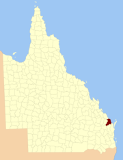
The County of Cook is a county in Queensland, Australia. Like all counties in Queensland, it is a non-functional administrative unit, that is used mainly for the purpose of registering land titles.

The county is centred on the city of Bundaberg,[1] and its name honours Captain James Cook. It was officially named and bounded by the Governor in Council on 7 March 1901 under the Land Act 1897.[2]

Parishes

Cook is divided into parishes, as listed below:

Parish LGA Coordinates
Barns Bundaberg 25°00′S 152°26′E / 25°S 152.433°E / -25; 152.433 (Barns Parish)
Barolin Bundaberg 24°50′S 152°26′E / 24.833°S 152.433°E / -24.833; 152.433 (Barolin Parish)
Bingera Bundaberg 25°01′S 152°15′E / 25.017°S 152.25°E / -25.017; 152.25 (Bingera Parish)
Booyal Bundaberg 25°08′S 152°03′E / 25.133°S 152.05°E / -25.133; 152.05 (Booyal Parish)
Broomfield North Burnett 25°27′S 152°11′E / 25.45°S 152.183°E / -25.45; 152.183 (Broomfield Parish)
Bundaberg Bundaberg 24°55′S 152°19′E / 24.917°S 152.317°E / -24.917; 152.317 (Bundaberg Parish)
Burrum Fraser Coast 25°19′S 152°32′E / 25.317°S 152.533°E / -25.317; 152.533 (Burrum Parish)
Cherwell Fraser Coast 25°15′S 152°27′E / 25.25°S 152.45°E / -25.25; 152.45 (Cherwell Parish)
Childers Bundaberg 25°15′S 152°18′E / 25.25°S 152.3°E / -25.25; 152.3 (Childers Parish)
Chowey North Burnett 25°28′S 151°52′E / 25.467°S 151.867°E / -25.467; 151.867 (Chowey Parish)
Coringa North Burnett 25°21′S 151°56′E / 25.35°S 151.933°E / -25.35; 151.933 (Coringa Parish)
Dallarnil North Burnett 25°22′S 152°03′E / 25.367°S 152.05°E / -25.367; 152.05 (Dallarnil Parish)
Degilbo North Burnett 25°30′S 151°56′E / 25.5°S 151.933°E / -25.5; 151.933 (Degilbo Parish)
Electra Bundaberg 25°04′S 152°07′E / 25.067°S 152.117°E / -25.067; 152.117 (Electra Parish)
Eureka Bundaberg 25°17′S 152°10′E / 25.283°S 152.167°E / -25.283; 152.167 (Eureka Parish)
Gooburrum Bundaberg 24°46′S 152°19′E / 24.767°S 152.317°E / -24.767; 152.317 (Gooburrum Parish)
Gregory Bundaberg 25°08′S 152°15′E / 25.133°S 152.25°E / -25.133; 152.25 (Gregory Parish)
Hercules Bundaberg 25°08′S 152°34′E / 25.133°S 152.567°E / -25.133; 152.567 (Hercules Parish)
Isis Bundaberg 25°10′S 152°26′E / 25.167°S 152.433°E / -25.167; 152.433 (Isis Parish)
Kalkie Bundaberg 24°53′S 152°23′E / 24.883°S 152.383°E / -24.883; 152.383 (Kalkie Parish)
Kinagin Bundaberg 24°50′S 152°00′E / 24.833°S 152°E / -24.833; 152 (Kinagin Parish)
Kolbore Fraser Coast 25°20′S 152°25′E / 25.333°S 152.417°E / -25.333; 152.417 (Kolbore Parish)
Kullogum Bundaberg 25°21′S 152°15′E / 25.35°S 152.25°E / -25.35; 152.25 (Kullogum Parish)
Marathon Bundaberg 25°06′S 152°26′E / 25.1°S 152.433°E / -25.1; 152.433 (Marathon Parish)
Mungore North Burnett 25°35′S 152°03′E / 25.583°S 152.05°E / -25.583; 152.05 (Mungore Parish)
North Kolan Bundaberg 24°46′S 152°11′E / 24.767°S 152.183°E / -24.767; 152.183 (North Kolan Parish)
Otoo Bundaberg 24°46′S 152°15′E / 24.767°S 152.25°E / -24.767; 152.25 (Otoo Parish)
South Kolan Bundaberg 24°54′S 152°10′E / 24.9°S 152.167°E / -24.9; 152.167 (South Kolan Parish)
Stanton Bundaberg 25°14′S 152°03′E / 25.233°S 152.05°E / -25.233; 152.05 (Stanton Parish)
Takalvan Bundaberg 24°54′S 152°15′E / 24.9°S 152.25°E / -24.9; 152.25 (Takalvan Parish)
Tantitha Bundaberg 24°52′S 152°15′E / 24.867°S 152.25°E / -24.867; 152.25 (Tantitha Parish)
Walsh Fraser Coast 25°15′S 152°36′E / 25.25°S 152.6°E / -25.25; 152.6 (Walsh Parish)
Woowoonga North Burnett 25°28′S 152°04′E / 25.467°S 152.067°E / -25.467; 152.067 (Woowoonga Parish)
Yandaran Bundaberg 24°45′S 152°07′E / 24.75°S 152.117°E / -24.75; 152.117 (Yandaran Parish)

See also

References

  1. ^ Wide Bay/Burnett District, County of Cook Maps - D3 Series at Queensland Archives.
  2. ^ Department of Environment and Resource Management. "Place name details — March". http://www.derm.qld.gov.au/property/placenames/details.php?id=20922. Retrieved 4 June 2011. 

Coordinates: 24°52′S 152°21′E / 24.867°S 152.35°E / -24.867; 152.35


Wikimedia Foundation. 2010.

Игры ⚽ Поможем написать реферат

Look at other dictionaries:

  • County of Banks, Queensland — Banks Queensland Location within Queensland Lands administrative divisions around Banks …   Wikipedia

  • Cook — may refer to: Cook (profession) Cook (servant), a servant who cooks food for his or her employer Contents 1 Personal name 2 Place name …   Wikipedia

  • Cadastral divisions of Queensland — refers to the divisions of Queensland used for the registration of land titles. There are 322 counties, and 5,319 parishes within the state. [http://www.nrw.qld.gov.au/museum/articles complete/mapping/cad.html] . They are part of the cadastral… …   Wikipedia

  • County of Lennox — Lennox Queensland Location within Queensland Lands administrative divisions around Lennox …   Wikipedia

  • County of Solander — Solander Queensland Lands administrative divisions around Solander Banks Pacific Ocean Pacific Ocean …   Wikipedia

  • County of March — March Queensland Location within Queensland Lands administrative divisions around March …   Wikipedia

  • Cook County — Comté de Cook  Cette page d’homonymie répertorie les différents comtés partageant un même nom. États Unis Trois comtés des États Unis portent le nom de comté de Cook (Cook County) : le comté de Cook, situé dans l État de Géorgie ;… …   Wikipédia en Français

  • County of Nares — Nares Queensland Location within Queensland Lands administrative divisions around Nares …   Wikipedia

  • James Cook — Porträt von Nathaniel Dance, 1776, National Maritime Museum …   Deutsch Wikipedia

  • Electoral district of Cook's River — Cook s River was an electoral district of the Legislative Assembly in the Australian state of New South Wales, created in 1941, partly replacing Arncliffe, and named after inner southwestern Sydney s Cooks River. It was abolished in 1973.[1]… …   Wikipedia

Share the article and excerpts

Direct link
Do a right-click on the link above
and select “Copy Link”