- County of Nares
-
Nares
Queensland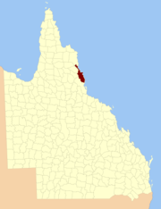
Location within QueenslandLands administrative divisions around Nares Chelmsford Solander Pacific Ocean Dagmar Nares Pacific Ocean Hodgkinson Cardwell Pacific Ocean The county of Nares is a cadastral division of Queensland which contains the city of Cairns. It was named after George Nares (1831–1915), a naval officer and commander of the HMS Salamander.[1] Cairns is mentioned as being in the county of Nares in the 1911 Britannica.[2] It is bounded by the Daintree River in the north.[3]
Parishes
Nares is subdivided into parishes, listed as follows:
References
- ^ Queensland government, place name details
- ^ 1911 Britannica, Cairns
- ^ Cook District, County of Nares Maps - P9 Series at Queensland Archives.
Categories:- Counties of Queensland

Wikimedia Foundation. 2010.