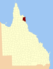
- County of Banks, Queensland
-
Banks
Queensland
Location within QueenslandLands administrative divisions around Banks Melville Melville Mosman Banks Coral Sea Chelmsford Dagmar Solander The county of Banks is one of the counties of Queensland that existed before 1901. It is located in Far North Queensland, and is named for Sir Joseph Banks, who with Captain James Cook landed in 1770 at a location within the county. Banks includes the towns of Cooktown and Laura.[1][2]
Parishes
Parish LGA Coordinates Annan Cook 15°35′S 145°15′E / 15.583°S 145.25°E Cook Cook 15°30′S 145°14′E / 15.5°S 145.233°E Deighton Cook 15°30′S 144°33′E / 15.5°S 144.55°E Flattery Cook 14°54′S 145°11′E / 14.9°S 145.183°E Gore Cook 15°52′S 145°04′E / 15.867°S 145.067°E Hann Hope Vale (A) 15°20′S 145°07′E / 15.333°S 145.117°E McIvor Cook 15°07′S 145°03′E / 15.117°S 145.05°E Monkhouse Cook 15°45′S 145°17′E / 15.75°S 145.283°E Solander Cook 15°27′S 145°06′E / 15.45°S 145.1°E References
- ^ "Place name details: Banks". Queensland Government (Department of Environment and Resource Management). 4 March 2008. http://www.derm.qld.gov.au/property/placenames/detail.php?id=1515. Retrieved 2009-11-04.
- ^ Cook District, County of Banks Maps - N3 Series at Queensland Archives.
Categories:- Counties of Queensland
- Queensland geography stubs
Wikimedia Foundation. 2010.
