- Church of St Michael, Princetown
-
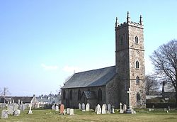
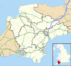
Church of St Michael Location: Princetown, Devon, England Coordinates: 50°32′46″N 3°59′46″W / 50.54611°N 3.99611°WCoordinates: 50°32′46″N 3°59′46″W / 50.54611°N 3.99611°W Built: 1810-1814 Listed Building – Grade II* Official name: Church of St Michael Designated: 21 March 1967[1] Reference #: 92795 The Anglican Church of St Michael (sometimes known as St Michael and All Angels) in Princetown, Devon, England was built between 1810 and 1814. It has been designated by English Heritage as a Grade II* listed building,[1] and is now a redundant church in the care of the Churches Conservation Trust.[2]
The granite church stands near the middle of Dartmoor, 436 metres (1,430 ft) above sea level in an exposed location close to Dartmoor Prison. Permission for the construction of the church was given 1812 by the Lord Commissioners of the Admiralty.[3] The church was designed by the architect Daniel Alexander and built by prisoners from the Napoleonic Wars and finished by those captured during the American war who were held in the prison,[4][5] and is the only church in England to have been built by prisoners of war.[2][6][7]
The three stage west tower is surmounted by pinnacles.[1] Prisoners of war were held in the prison until 1816 and then the church closed. It was reopened and reconsecrated in 1831. In 1868 the chancel was altered and between 1898 and 1901 further alterations and expansion were undertaken under the direction of Edmund Sedding. In 1915 the tower was restored.[3]
The east window has stained glass by Mayer of Munich,[3] which was installed in 1910 in memory of the American prisoners who helped to build the church.[2] The graves of many prisoners are in the churchyard. The window was partially funded by a donation of £250, in 1908, from the National Society Daughters of the American Colonists as part of their work commemorating those who died in the War of 1812.[3] The church was declared redundant on 1 November 1995, and was vested in the Trust on 8 January 2001.[8] It is still consecrated and it is used occasionally for services.[7]
See also
- List of churches preserved by the Churches Conservation Trust in South West England
References
- ^ a b c "Church of St Michael". Images of England. english Heritage. http://www.imagesofengland.org.uk/Details/Default.aspx?id=92795. Retrieved 17 October 2010.
- ^ a b c Church of St Michael & All Angels, Princetown, Devon, Churches Conservation Trust, http://www.visitchurches.org.uk/Ourchurches/Completelistofchurches/Church-of-St-Michael-All-Angels-Princetown-Devon/, retrieved 2 April 2011
- ^ a b c d "Church of St Michael". Pastscape. English Heritage. http://pastscape.english-heritage.org.uk/hob.aspx?hob_id=1507817. Retrieved 17 October 2010.
- ^ Campbell, Sophie (2009-05-01). "Dartmoor prison turns to captivating tourists". The Telegraph. http://www.telegraph.co.uk/travel/familyholidays/5251563/Dartmoor-prison-turns-to-captivating-tourists.html. Retrieved 17 October 2010.
- ^ "Potted History of Princetown". High Moorland Community Action Ltd. http://www.hmca.org.uk/history/index.html. Retrieved 17 October 2010.
- ^ "St Michaels Church Princetown". St Michaels Church Princetown. http://www.princetownstmichaels.org.uk/. Retrieved 17 October 2010.
- ^ a b "Princetown, St Michael's Church". Britain Express. http://www.britainexpress.com/attractions.htm?attraction=3952. Retrieved 17 October 2010.
- ^ (PDF) Diocese of Exeter: All Schemes, Church Commissioners/Statistics, Church of England, 2011, p. 4, http://www.churchofengland.org/media/810520/exeter%20-%20all%20schemes.pdf, retrieved 2 April 2011
Categories:- Church of England churches in Devon
- Buildings and structures completed in 1814
- Grade II* listed churches
- Grade II* listed buildings in Devon
- Churches preserved by the Churches Conservation Trust
Wikimedia Foundation. 2010.


