- Cheruvannur (Koyilandy taluk)
-
Cheruvannur Grama Panchayat
ചെറുവണ്ണൂര് ഗ്രാമ പഞ്ചായത്തു്
— town — 
SealCoordinates 11°34′N 75°43′E / 11.57°N 75.71°ECoordinates: 11°34′N 75°43′E / 11.57°N 75.71°E Country India Region South India State Kerala District(s) Kozhikode President Nalini Nallur Population
• Density
22,150 (2001[update])
• 1,025 /km2 (2,655 /sq mi)
Time zone IST (UTC+05:30) Area 21.61 square kilometres (8.34 sq mi) Website cheruvannur.web4all.in Cheruvannur one of the 78 grama panchayats of Kozhikode district, lies between North Latitude 11° 32′ 37.11” and 11° 36′ 4.67”, East Longitude 75° 40′ 26.32” and 75° 43′ 55.22”. It has a total area of 21.61 square kilometers. The adjoining grama panchayats are Thiruvallur and Velom in the north, Perambra in the east, Nochad, Meppayur, and Thurayur in the south, Maniyur and Thiruvallur in the west. The Kuttiyadi river, erstwhile known as Kotta river is flowing from north to south, through the eastern side, detaches the grama panchayat from Vadakara taluk. The physiography is not planar. The ridges of smaller and medium hills and low lying valleys make the area an undulating terrain. Grama panchayat can be divided into three, according to the physiography – viz, hilly area, slopes and valleys. The highest area in grama panchayat is Purakkamala (പുറക്കാമല) noted with a height of 115 metres above sea level. Cheruvannur Grama panchayat includes some of the lowest lying places of the region, and parts of these areas are often flooded during monsoon.
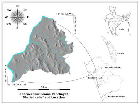 Cheruvannur Grama Panchayat location and shaded relief.
Contents
History
Formed in the year 1934 it is one of the oldest grama panchayats in the state. The area has a long history of human settlements. A hat stone (തൊപ്പിക്കല്ല്) - megalithic burial monument - belongs to roughly a period of 300 B.C. to 500 A.D (Ganesh, K.M., 1990.) is seen in Edakkayil (എടക്കയില്) as a proof. A cave (Innes. C.A, Evans. F.B.(Ed.), 1958) is also present in Moyiloth (മൊയിലോത്ത്) near Muyippoth belongs to the same period, now lies under thick soil cover which was carelessly deposited on it during the construction of irrigation canal passing there by, remains almost forgotten.
Before British occupation, the place was included in Payyormala (പയ്യോര്മല) a feudal principality controlled by three nair families namely Paleri (പാലേരി), Avinhatt (അവിഞ്ഞാട്ട്), and Koothali (കൂത്താളി) and those acknowledged the suzerainty of Zamorin of Calicut (കോഴിക്കോട് സാമൂതിരി) (Innes. C.A, Evans. F.B.(Ed.), 1958). Payyormala is a slightly elevated area near Edakkayil, from where the name of the principality evolved, now remains a place of less importance. Remnants of a small shrine of payyormala muthassi (പയ്യോര്മല മുത്തശ്ശി) the guardian angel of the principality, still seen here. Under British administration the area included in Kurumbranad taluk, Malabar district of Madras presidency (Innes. C.A, Evans. F.B.(Ed.), 1958). At present it find its place in Perambra development block and in Koyilandi taluk, Kozhikode district of Kerala state. The people from the region has a rich tradition of participation in various important historical events, among them Pazhassi revolts (പഴശ്ശി സമരം) against the rule of British East India Company took place between 1796 to 1805 and Koothali strike (കൂത്താളി സമരം) took place in the period of 1940 -1950 are most notable. Many of freedom fighters who participated in mainstream freedom struggle, and two people who joined in I.N.A and fought against the British were from this area.
Grama panchayat Profile
Grama panchayat is divided into 14 ward constituencies for developmental and administrative purposes. The representative members are elected from each ward for a quinquennium to the grama panchayat administrative committee. In the period of 1990-1995 the number of wards were 9, in 1995-2000 it was 10, in 2000-2005 period it increased as 12 and now, for the period of 2005-2010 the number of ward constituencies are 14. The increase in number of wards is based on the criteria set up by the State Election Commission, which finds the basics of increase in population, increase in the number of households etc.
The total population of Cheruvannur grama panchayat is 22150 and number of households are 4663 (Census 2001). It has a good connectivity of 27.477 kilometers of paved and 59.670 kilometers of unpaved roads. A total number of 65 ponds 12.629 kilometers of irrigation canal is present now.
In health sector, people of Cheruvannur Grama Panchayat have accessibility to the three systems of medicine by the presence of 1 Govt. Primary Heath Centre , three Family Welfare centres, 1 Govt. Ayurveda Hospital and a Govt. Homeopathy dispensary. A total number of 20 Anganwadi centres serve the child welfare part very well.
In education sector, 10 lower primary schools, three upper primary schools, 1 high school, 1 higher secondary school, 1 un-aided school are present, and among them 1 U. P. School , 1 L. P. School, high school and higher secondary school are in Govt sector.
Life
Avala pandi paddy field hosts numerous migratory birds each year. Sacred groves are places of worship and at the same time, traditional method of ecological conservation. Place has an immense activity in agriculture particularly in rice cultivation. The area has a good potential for eco-tourism, with its scenic beauty not known much outside, connectivity of roads, sensible people, essential communication and medical facilities.
The major source of income for the people living nearby river, is sand mining from the Kuttiyadi river. Sand mining activity is controlled by grama panchayat, district collector, and district level kadavu committee jointly. This is the major income source to own fund for grama panchayat also.
Demography
As of 2001[update] India census,[1] Cheruvannur had a population of 22,150. Males constitute 49% of the population and females 51%. Cheruvannur has an average literacy rate of 81%, higher than the national average of 59.5%; with male literacy of 86% and female literacy of 77%. 13% of the population is under 6 years of age.
Trivia
Cheruvannur grama panchayat is often mistaken with Cheruvannur-Nallalom grama panchayat both in official and civil correspondences by its name, the later lies in Kozhikode taluk of Kozhikode district itself.
References
- ^ "Census of India 2001: Data from the 2001 Census, including cities, villages and towns (Provisional)". Census Commission of India. Archived from the original on 2004-06-16. http://web.archive.org/web/20040616075334/http://www.censusindia.net/results/town.php?stad=A&state5=999. Retrieved 2008-11-01.
Cities and towns in Kozhikode district Kozhikode Beypore · Balussery · Chorode · Edacheri · Cheruvannur · Elathur · Eramala · Feroke · Kadalundi · Kappad · Karuvanthuruthy · Koduvally · Quilandy · Kozhikode · Kunnamangalam · Kuttiyadi · Maniyur · Mavoor · Meppayur · Mukkam · Nadapuram · Olavanna · Orkkatteri · Pantheeramkavu · Payyoli · Perambra · Purameri · Ramanattukara · Thamarassery · Thiruvambadi · Vatakara · Villiappally.
Cities and towns
in other districtsAlappuzha · Ernakulam · Idukki · Kannur · Kasaragod · Kollam · Kottayam · Malappuram · Palakkad · Pathanamthitta · Thiruvananthapuram · Thrissur · Wayanad
Categories:- Cities and towns in Kozhikode district


Wikimedia Foundation. 2010.