- Chak Kazi Barrpura
-
Chak Kazi Barrpura
चक काजी बर्रपुरा
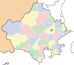
— village — Coordinates 27°7′31″N 77°32′8″E / 27.12528°N 77.53556°ECoordinates: 27°7′31″N 77°32′8″E / 27.12528°N 77.53556°E Country India State Rajasthan District(s) Bharatpur Nearest city Bharatpur Parliamentary constituency Bharatpur Assembly constituency Nadbai Population 830 Sex ratio 1000:860 ♂/♀ Literacy 56% Time zone IST (UTC+05:30) Chak Kazi Barrpura ( Hindi: चक काजी बर्रपुरा also spelled as 'Barrpura', 'Barrapura', 'Chak Qazi',Chak Kazi or 'Chak Kaji') is small village about 12 km from Bharatpur, India in Rajasthan state. This village is located beside the Keoladeo National Park (KNP) in south-west side of its boundary.
Contents
Social and Developmental Canvas
Most of villagers are farmers. Based on census of India 2001, there are 124 families in the village and the population is 830. Male population is 446 and female population is 384 (sex ratio = 1000:860).Total agriculture labor is 97 and working population is 170. Total literacy is 56 percent. Male literacy is 67 percent. Female literacy is 43 percent.
There are all Jatav families including one mehtar family in the village. All the people belong to Scheduled caste (SC), a socially backward class mentioned in Constitution of India.
2001 Census report of village [1]
No of Households 124 Total Population 830 Population below 06 yrs 192 Male Population 446 Population below 06 Male 109 Female Population 384 Population below 06 Female 83 Total Agriculture Labour 97 Marginal Agriculture Labour - Male 7 Marginal Agriculture Labour - Female 90 Literate Population 466 Illiterate Population 364 Male Literate 301 Male illiterate population 145 Female Literate 165 Female illiterate population 219 No of Households 124 Working Population 358 Main working population 170 Main Working Population Male 10 Main Working Population Female 160 Main Casual Working Population 71 Total Casual labour Main Casual Working Population Male 3 Main Casual Working Population Female Number of SC 829 Male SC Population 445 Female SC Population 384 Number of ST 0 Male ST Population 0 Female ST Population 0 Geography
The geographis location of the village is 27°7′31″N 77°32′8″E / 27.12528°N 77.53556°E.[2] The Address of village is : Village-Barrpura, Post- Aghapur, District- Bharatpur - 321001 (Rajasthan).
The neighboring villages are: Aghapur (अघापुर) , Darapur kala (दारापुर कला) , Darapur Khurd(दारापुर खुर्द) Nagla Banjara (नगला बंजारा), Chak Naswaria(चक नसवारिया), Nagla Bajho (नगला बझो) , Chak New(nau) (नाऊ चक), Nagla Punjabi (नगला पंजाबी ), Kalyanpur (कल्यानपुर), Chak Chaube (चक चौबे), Chaukipura (चौकीपुरा), Kaproli (कपरोली). Ajan dam (अजान बांध) is located near these villages.
History
The people of this village came from three villages: Veerampura, Ghughupura and Bilothi in about 1960. Half part of the village (by population as well as residence area) is formed by the people came from Veerampura and another half is formed by the people came from Ghughupura and Bilothi, making each half of it.
Economy
Residents depend on agriculture economically. Due to poor condition of agriculture in India, they are economically backward, as like other villages in India. Few people are also in other government and private sectors.
Education
There is one government primary school in the village. The students of the village have to go another village after fifth class for further reading. Even male child education is not satisfactory, the condition of girl child education is poorer. There is only one government primary school in the village.
Normally, status of primary education in India, specially in villages, is very poor. For most villagers government schools are only options to provide education to their children. They find themselves unable to afford high fees of private or public schools. Government machinery of primary education in India is worst. It is not because of government primary teachers are less paid, It is because of these teachers are corrupted like most other government sectors and there is always lack of basic infrastructure in these primary educational institutes.
See also
Chak Kazi village- Social and developmental canvas
Villages in Bharatpur District
Rajiv Gandhi Gramin Vidyutikaran Yojana - Progress of Village Electrification
Quality affected habitations in Bharatpur District
List of Villages in Bharatpur District
 List of Villages in Bharatpur District]
References
Bharatpur Cities and towns
in other districtsAjmer · Alwar · Banswara · Baran · Barmer · Bhilwara · Bikaner · Bundi · Chittorgarh · Churu · Dausa · Dholpur · Dungarpur · Hanumangarh · Jaipur · Jaisalmer · Jalore · Jhalawar · Jhunjhunu · Jodhpur · Karauli · Kota · Nagaur · Pali · Pratapgarh · Rajsamand · Sawai Madhopur · Sikar · Sirohi · Sri Ganganagar · Tonk · Udaipur
State of Rajasthan (India) Major cities 
Divisions Districts Ajmer · Alwar · Banswara · Baran · Barmer · Bharatpur · Bhilwara · Bikaner · Bundi · Chittorgarh · Churu · Dausa · Dholpur · Dungarpur · Hanumangarh · Jaipur · Jaisalmer · Jalore · Jhalawar · Jhunjhunu · Jodhpur · Karauli · Kota · Nagaur · Pali · Pratapgarh · Rajsamand · Sawai Madhopur · Sikar · Sirohi · Sri Ganganagar · Tonk · UdaipurCategories:- Villages in Bharatpur district
Wikimedia Foundation. 2010.


