- Okharkot
-
Okharkot
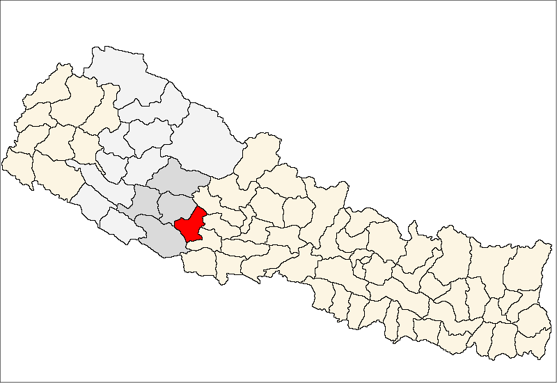
ओखरकोत— Village Development Committee — Location in Nepal
 Okharkot
Coordinates: 28°08′N 82°59′E / 28.14°N 82.98°ECoordinates: 28°08′N 82°59′E / 28.14°N 82.98°E Country  Nepal
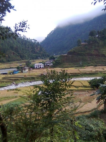
NepalDevelopment Region Mid-Western Zone Rapti Zone District Pyuthan District VDC Okharkot Population (2001 Census[1]) - Total 4,484 836 households Time zone Nepal Time (UTC+5:45) 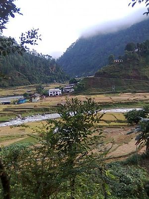 Machcchi Village, administrative center of Okharkot VDC with Gartang Khola in the foreground
Okharkot is a town and Village Development Committee in Pyuthan, a Middle Hills district of Rapti Zone, western Nepal.
Contents
Etymology
Okhar (Nepali: ओखर) - walnut tree (Juglans regia).
kot (Nepali: कोट) - guardroom, prison, police station.Villages in this VDC[2]
Ward Lat. Lon Elev. Ahal आहाल 6 28°10'N 83°00'E 1,089m Aphrekholagaun आफ्रेखोलागाउँ 28°09'N 82°59'E 1,205 Arupata आरुपाटा 28°09'N 82°59'E 1,045 Badikholagaun बादीखोलागाउँ 28°09'N 82°59'E 1,210 Banstari बाँसटारी 28°08'N 82°58'E 1,205 Bebare बेबरे 28°10'N 83°00'E 1,590 Bhedabari भेडाबारी 28°10'N 83°00'E 1,255 Chauke चौके 9 28°07'N 82°58'E 1,542 Chichinne चिचिन्ने 28°07'N 82°57'E 1,710 Chudhara चुधारा 8 28°08'N 82°58'E 1,110 Darimchaur दारिमचौर 6 28°09'N 82°59'E 1,030 Dhana ढाँणा 28°09'N 82°58'E 1,050 Dhana Bajar ढाँडाबजार 28°09'N 82°58'E 995 Hariya हरिया 28°10'N 82°59'E 1,170 Kalleri कल्लेरी 28°08'N 82°59'E 1,597 Kamdale कमडाले 28°07'N 82°58'E 1,642 Kami Tol कामी टोल 28°08'N 83°00'E 1,475 Khahare खहरे 28°08'N 82°59'E 1,030 Koiralpata कोइरलपाटा 28°09'N 82°59'E 1,090 Kubinde कुबिण्डे 28°07'N 82°58'E 1,470 Lamasera लामासेरा 28°10'N 82°59'E 1,018 Machchhi मच्छी 1 28°08'N 82°58'E 955 Okharkot ओखरकोट 28°08'N 82°59'E 1,630 Ratamata रातामाटा 28°08'N 83°00'E 1,538 Ripapakha रिपापाखा 28°08'N 82°58'E 1,045 Rotepani रोटेपानी 28°09'N 82°59'E 1,170 Salleri सल्लेरी 28°08'N 82°58'E 1,610 Samaldhara समलधारा 28°10'N 82°59'E 1,418 Sisnekholagaun सिस्नेखोलागाउँ 28°09'N 83°00'E 1,285 Swanbota स्वाँबोटा 28°08'N 82°58'E 955 Tada Pokhari टाडा पोखरी 28°08'N 82°58'E 1,285 Tari टारी 28°07'N 82°59'E 1,285 Tilahalna तिलाहाल्ना 28°08'N 82°57'E 955 Machcchī is the VDC's administrative center at the confluence of Dharmawati River and Gartang Khola. Okharkot village with its ancient fortress sits on a ridgetop 2 km. east and some 675 meters (2200 feet) higher. It is listed in IUCN's inventory of historic sites. [3]
References
- ^ "Nepal Census 2001". Nepal's Village Development Committees. Digital Himalaya. http://www.digitalhimalaya.com/collections/nepalcensus/form.php?selection=1. Retrieved 21 September 2008.
- ^ "Index of Geographical Names of Nepal, Volume IV: Mid Western Development Region, List of Settlements, Pyuthan". Government of Nepal, National Geographic Information Infrastructure Program. http://www.ngiip.gov.np/pdf/vol4pyuthan.pdf. Retrieved 2011-03-12.
- ^ Bhandari, Bishnu, ed (1997). Inventory of heritage sites in Nepal. Kathmandu: IUCN Nepal. http://data.iucn.org/dbtw-wpd/exec/dbtwpub.dll?AC=GET_RECORD&XC=/dbtw-wpd/exec/dbtwpub.dll&BU=http%3A%2F%2Fdata.iucn.org%2Fdbtw-wpd%2Fcommande%2Findex_newsite.htm&TN=iucn&SN=AUTO463&SE=612&RN=0&MR=20&TR=0&TX=1000&ES=0&CS=1&XP=&RF=WebRes&EF=&DF=WebAff&RL=0&EL=0&DL=0&NP=254&ID=&MF=&MQ=&TI=0&DT=&ST=0&IR=1832&NR=0&NB=0&SV=0&BG=&FG=&QS=&OEX=ISO-8859-1&OEH=ISO-8859-1. Retrieved April 15, 2011.
External links
Arkha, Badikot, Bangesal, Baraula, Barjiwang, Belwaspur, Bhingri, Bijaya Nagar, Bijubar, Bijuli, Chuja, Dakhakuwadi Salghari, Damri, Dangwang, Dharamawati, Dharampani, Dhobaghat, Dhuwang, Dungegadi, Gothiwang, Hansapur, Jumrikanda, Khaira, Khawang, Khung, Kochiwang, Ligha, Liwang, Lung, Majhakot, Maranthana, Markawang, Narikot, Naya Gaun, Okharkot, Pakala,
Phopli, Puja, Rajbara, Ramdi, Ruspur Kot, Sari, Swargadwarikhal, Syauliwang, Tarwang, Tiram, Tusara, Wangemarkot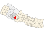 Categories:
- Populated places in Pyuthan District
- Rapti Zone geography stubs

Wikimedia Foundation. 2010.