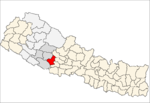
- Dharampani, Rapti
-
Dharampani
धरमपानी— Village Development Committee — Location in Nepal Coordinates: 28°04′N 82°45′E / 28.07°N 82.75°ECoordinates: 28°04′N 82°45′E / 28.07°N 82.75°E Country  Nepal
NepalRegion Mid-Western Zone Rapti Zone District Pyuthan District VDC Dharampani Wards Population (2001 Census[1]) – Total 2,859 560 households Time zone Nepal Time (UTC+5:45) Dharampani is a village and Village Development Committee in Pyuthan, a Middle Hills district of Rapti Zone, western Nepal.
Villages in VDC[2]
Ward Lat. Lon Elev. Argeli अर्गेली 28°03'N 82°56'E 1,079m Banchare बन्चरे 28°04'N 82°55'E 1,190 Barbot बरबोट 8 28°04'N 82°56'E 1,272 Bhedikhore भेडीखोरे 28°03'N 82°56'E 870 Bujathati बुजाथाटी 28°03'N 82°57'E 805 Bukeni बुकेनी 5 28°05'N 82°55'E 1,685 Chauthi Laune चौथी लाउने 28°04'N 82°56'E 1,308 Chhap छाप 28°04'N 82°55'E 1,170 Dhanubas धनुबास 28°05'N 82°55'E 1,370 Dharampani धरमपानी 2 28°04'N 82°54'E 1,250 Gahtara गहतरा 28°04'N 82°56'E 1,045 Girichaur गिरीचौर 1 28°04'N 82°53'E 1,570 Jebundanda जेबुनडाँडा 28°04'N 82°55'E 1,142 Khanidanda खानीडाँडा 28°03'N 82°53'E 1,210 Maidan मैदान 28°04'N 82°56'E 1,198 Manjh Pokhara माँझ पोखरा 28°04'N 82°56'E 1,170 Mundanda मुनडाँडा 28°04'N 82°56'E 1,418 Nisan Takura निसान टाकुरा 28°05'N 82°55'E 1,461 Sirkot सिरकोट 28°04'N 82°53'E 1,485 Tallo Takura तल्लो टाकुरा 28°04'N 82°56'E 1,100 References
- ^ "Nepal Census 2001". Nepal's Village Development Committees. Digital Himalaya. http://www.digitalhimalaya.com/collections/nepalcensus/form.php?selection=1. Retrieved 21 September 2008.
- ^ "Index of Geographical Names of Nepal, Volume IV: Mid Western Development Region, List of Settlements, Pyuthan". Government of Nepal, National Geographic Information Infrastructure Program. http://www.ngiip.gov.np/pdf/vol4pyuthan.pdf. Retrieved 2011-03-12.
External links
Arkha, Badikot, Bangesal, Baraula, Barjiwang, Belwaspur, Bhingri, Bijaya Nagar, Bijubar, Bijuli, Chuja, Dakhakuwadi Salghari, Damri, Dangwang, Dharamawati, Dharampani, Dhobaghat, Dhuwang, Dungegadi, Gothiwang, Hansapur, Jumrikanda, Khaira, Khawang, Khung, Kochiwang, Ligha, Liwang, Lung, Majhakot, Maranthana, Markawang, Narikot, Naya Gaun, Okharkot, Pakala,
Phopli, Puja, Rajbara, Ramdi, Ruspur Kot, Sari, Swargadwarikhal, Syauliwang, Tarwang, Tiram, Tusara, Wangemarkot Categories:
- Populated places in Pyuthan District
- Rapti Zone geography stubs
Wikimedia Foundation. 2010.

