Canal Road, Hong Kong

Canal Road, Hong Kong
Canal Road
堅拿道
HK Wan Chai Canal Road East wo.JPG
Local social service organizations in Canal Road
Location: Hong Kong
Bowrington Canal in 1920
Villain hitter and her client under the Canal Road Flyover in Hong Kong.

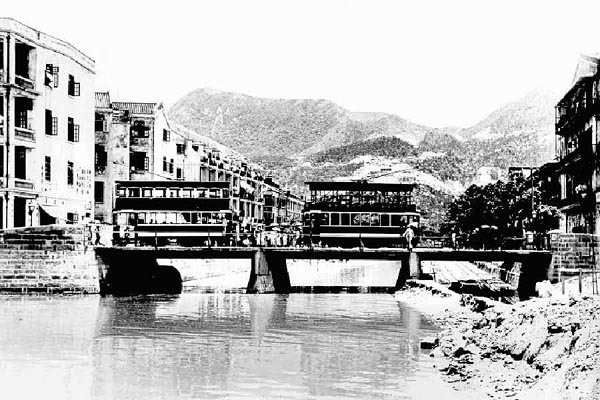
Canal Road East (Chinese: 堅拿道東), Canal Road West (Chinese: 堅拿道西) and the Canal Road Flyover (Chinese: 堅拿道天橋) are important roads in Wan Chai and Causeway Bay, Wan Chai District of Hong Kong.

Before urban development the area was the estuary of a river named "Wong Nai Chung", which looked like the neck of a goose. The 4th Governor of Hong Kong, John Bowring built Bowrington (or Bowring City) around the estuary. Bowrington Canal was built during the mid to late 1850s as the extension of Wong Nai Chung and the long and narrow canal was known as and thus known as Ngo Keng Kan (鵝頸澗, lit. goose neck stream). The landmark Bowrington Bridge built in 1861 across the canal was known as Ngo Keng Kiu (鵝頸橋, lit. goose neck bridge). The area surrounding are also known as Ngo Keng. During the reclamation of Wan Chai beside Victoria Harbour from 1922 to 1929, the canal was covered and made subterranean and the bridge was removed. However the name survives in the history and remains the name of the area.

Canal Road Flyover

Canal Road Flyover (traditional Chinese: 堅拿道天橋; simplified Chinese: 坚拿道天桥; pinyin: Jiānnádào Tiānqiáo; Cantonese Yale: gin1 na4 dou6 tin1 kiu4) was built in 1970s for the Cross-Harbour Tunnel, between Canal Road East and Canal Road West. Many who do not know the history of Canal Road might associate the flyover with Ngo Keng Kiu. It initially connected only Canal Road West to the north of Gloucester Road when it opened on 29 March 1972. Four years later, the flyover was expanded and extended south to the Aberdeen Tunnel entrance in Happy Valley in 1976. The flyover was expanded again and an exit connected to Canal Road East.

The flyover currently joins Aberdeen Tunnel and Cross Harbour Tunnel thoroghfare Causeway Bay in Wan Chai District, Hong Kong Island, Hong Kong. It is a very important bridge for travelling to the Southern District and Happy Valley. In order, it starts in the Wan Chai interchange, it passes-by Gloucester Road, Jaffe Road, Lockhart Road, Hennessy Road Times Square, Leighton Road, Queen's Road East, Racing Museum and Wong Nai Chung Road.

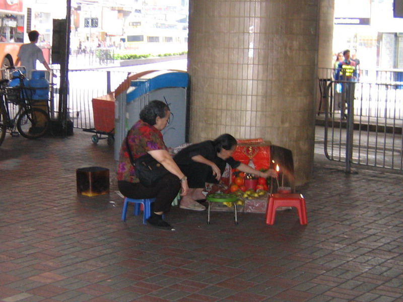
Under the Canal Road Flyover, Villain hitting activities are often seen especially in Jingzhe, which has become a feature in Hong Kong culture.

See also

External links

Canal Road, Hong Kong
Hong Kong Route 1 Chronology
HK Route1.svg
Preceded by
Aberdeen Tunnel
Canal Road (Flyover) Succeeded by
Cross-Harbour Tunnel

Coordinates: 22°16′40″N 114°10′52″E / 22.27791°N 114.18117°E / 22.27791; 114.18117


Wikimedia Foundation. 2010.

Игры ⚽ Нужно решить контрольную?

Look at other dictionaries:

  • Canal Road — is a street name in various locations, including the following:*Canal Road, Bradford West Gwillimbury in Bradford West Gwillimbury, Ontario, Canada *Canal Road (Washington, D.C.), U.S.A. *Canal Road (Hong Kong)Entertainment* Canal Road (TV… …   Wikipedia

  • Gloucester Road, Hong Kong — Gloucester Road (zh cpcy|c=告士打道|p=Gàoshìdǎ Dào|cy=gou3 si6 da2 dou6) is a major road in the north of Wan Chai and East Point on the Hong Kong Island of Hong Kong. It connects to Harcourt Road at its western end and it ends east along west side of …   Wikipedia

  • Happy Valley, Hong Kong — Happy Valley (zh t|t=快活谷; more popular form: 跑馬地, lit. horse racing ground, former name: 愉園) is a mostly residential suburb of Hong Kong, located in the north of Hong Kong Island. It is one of the early communities of Hong Kong. Administratively …   Wikipedia

  • Connaught Place, Hong Kong — Traditional Chinese 康樂廣場 Simplified Chinese …   Wikipedia

  • Davis Street, Hong Kong — This article is about the Hong Kong street. For other cities, see Davis Street. Davis Street, Hong Kong Davis Street (Chinese: 爹核士街; pinyin: Diēhéshì Jiē; Cantonese Yale: de1 wat6 si6 gaai1) is a street in Kennedy Town, on …   Wikipedia

  • Route 1 (Hong Kong) — Infobox road marker state= highway name=Route 1 name notes= route=1 alternate name= section= map custom=yes length=20.7km North, 20.6km South length round= length ref= length notes= established=1966 (Princess Margaret Road) decommissioned=… …   Wikipedia

  • East Point, Hong Kong — Chinese|t=東角|s=东角|y=dūng gok|j=dung1 gok3|p=Dōngjiǎo East Point was a cape on the northern shore of Hong Kong Island, Hong Kong. It was a pointed headland extended from Jardine s Hill, i.e. Lee Garden towards the Kellett Island. It marked the… …   Wikipedia

  • Oasis Hong Kong Airlines — 甘泉香港航空 IATA O8 ICAO OHK Callsign …   Wikipedia

  • List of streets and roads in Hong Kong — Here is a partial list of expressways, tunnels, bridges, roads, avenues, streets, crescents, squares and bazaars in Hong Kong.Routes Hong Kong s Transport Department is responsible for maintenance and control of highways and roadways. In 2004, a… …   Wikipedia

  • China Aerospace International Holdings, Ltd. Hong Kong — China Aerospace International Holdings Ltd. Type State owned Headquarters Hong Kong China Aerospace International Holdings Ltd. or China Aerospace International Holdings, Ltd. (Space Holdings) (Chinese: 中國航天國際控股有限公司) (SEHK:  …   Wikipedia

Share the article and excerpts

Direct link
Do a right-click on the link above
and select “Copy Link”