- Diepholz (district)
-
Diepholz — District — 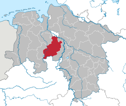
Country  Germany
State Lower Saxony Capital Diepholz Area - Total 1,987 km2 (767.2 sq mi) Population (31 December 2010)[1] - Total 213,558 - Density 107.5/km2 (278.4/sq mi) Time zone CET (UTC+1) - Summer (DST) CEST (UTC+2) Vehicle registration DH Website diepholz.de Diepholz (German pronunciation: [ˈdiːphɔlts]) is a district in Lower Saxony, Germany. It is bounded by (from the northeast and clockwise) the districts of Verden, Nienburg, Minden-Lübbecke (in North Rhine-Westphalia), Osnabrück, Vechta and Oldenburg, and by the cities of Delmenhorst and Bremen. The biggest city is Stuhr.
Contents
History
From the 12th century to 1585 Diepholz was a county within the Holy Roman Empire. At the beginning of the 16th century there was great pressure from the powerful duchy of Brunswick-Lüneburg, which tried to annex the smaller states. By forming an alliance with the neighbouring County of Hoya and asking for help from the emperor himself the state of Diepholz managed to survive some more decades. In 1585 the ruling family became extinct, and Diepholz was eventually annexed by Brunswick-Lüneburg.
In 1932, the district of Grafschaft Diepholz (County of Diepholz) was established by merging the former districts of Diepholz and Sulingen. The former district of Diepholz was roughly identical to the medieval state, while the Sulingen district had been a part of the County of Hoya.
The present district of Diepholz was formed in 1977 by merging the former districts of Grafschaft Diepholz (County of Diepholz) and Grafschaft Hoya (County of Hoya).
Geography
The district extends from the southern outskirts of Bremen to the border of North Rhine-Westphalia. In the south there is the Dümmer, a lake with an area of 16 km², which is surrounded by fens. Many rare bird species breed in the reeds around the lake. The northern portions of the district are occupied by forests and agricultural lands.
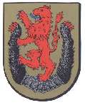
Coat of arms
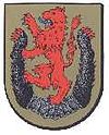
The lion is taken from the original arms of the Count of Diepholz. The bear claws are from the arms of Count of Hoya. This combination symbolizes the merger of County of Diepholz and County of Hoya in 1977.
Cities and municipalities
Towns Samtgemeinden
Free municipalities- 2. Barnstorf
- 4. Kirchdorf
- 5. Rehden
- 6. Schwaförden
- 7. Siedenburg
1seat of the Samtgemeinde References
- ^ "Bevölkerungsfortschreibung" (in German). Landesbetrieb für Statistik und Kommunikationstechnologie Niedersachsen. 31 December 2009. http://www1.nls.niedersachsen.de/statistik/html/parametereingabe.asp?DT=K1000014&CM=Bev%F6lkerungsfortschreibung.
External links
- Official website (German)
- Pictures from Diepholz (German)
- Lake Dümmer (German)
- historical pictures of Diepholz
 Urban and rural districts in the state of Lower Saxony in Germany
Region HanoverUrban districts Rural districts Ammerland · Aurich · Bentheim · Celle · Cloppenburg · Cuxhaven · Diepholz · Emsland · Friesland · Gifhorn · Goslar · Göttingen · Hamelin-Pyrmont · Harburg · Heidekreis · Helmstedt · Hildesheim · Holzminden · Leer · Lüchow-Dannenberg · Lüneburg · Nienburg · Northeim · Oldenburg · Osnabrück · Osterholz · Osterode · Peine · Rotenburg · Schaumburg · Stade · Uelzen · Vechta · Verden · Wesermarsch · Wittmund · WolfenbüttelCategories:- Districts of Lower Saxony
- Diepholz district

Wikimedia Foundation. 2010.