Goslar (district)

Goslar (district)

Infobox German district
name=Goslar
state=Lower Saxony
capital=Goslar
regierungsbezirk=
area=965.07
population=150,723
population_as_of=2006-06-30
density=156
carsign=GS
url= [http://www.landkreis-goslar.de/ www.landkreis-goslar.de]

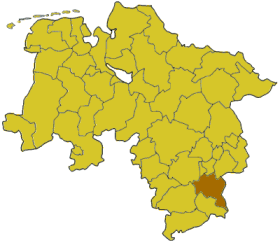
Goslar is a district in Lower Saxony, Germany. It is bounded by (from the south and clockwise) the districts of Osterode, Northeim, Hildesheim and Wolfenbüttel, the city of Salzgitter, and by the states of Saxony-Anhalt (district of Harz) and Thuringia (Nordhausen).

History

The history of the district is linked with the city of Goslar.

The district of Goslar was established in the 19th century by the Prussian government. The city of Goslar did not belong to the district until 1972, when it was eventually incorporated into the district.

Geography

The region comprises the northwestern part of the Harz mountains. The Harz National Park is part of this district. The highest peak is the Wurmberg (971 m) near Braunlage, also being the highest elevation of Lower Saxony. Above the small town of Altenau there is the source of the Oker river, which runs through the picturesque Oker valley to leave the Harz at Vienenburg.

Coat of arms

The eagle is the heraldic animal of the city of Goslar, while the lion symbolises the municipality of Schladen. Schladen is not part of the district, but the lords of Schladen ruled over major parts of the district in the early Middle Ages.

Towns and municipalities

External links

* [http://www.landkreis-goslar.de/ Official website] (German)


Wikimedia Foundation. 2010.

Игры ⚽ Нужно сделать НИР?

Look at other dictionaries:

  • Goslar — Infobox German Location Art = Stadt Wappen = Wappen Goslar.svg lat deg = 51 | lat min = 54 | lat sec = 26 lon deg = 10 | lon min = 25 | lon sec = 48 Bundesland = Lower Saxony Landkreis = Goslar Höhe = 255 Fläche = 92.58 Einwohner = 43058 Stand =… …   Wikipedia

  • Goslar (arrondissement) — Arrondissement de Goslar Arrondissement de Goslar Landkreis Goslar Données générales …   Wikipédia en Français

  • Oker (Goslar) — The coat of arms of Oker Oker has been part of the borough of Goslar in central Germany since 1972. It lies on the edge of the Harz mountains and has a population of 7,282 (as at 2006). Previously Oker had been a parish within Wolfenbüttel… …   Wikipedia

  • Arrondissement de Goslar — 51°54′38″N 10°25′16″E / 51.91056, 10.42111 …   Wikipédia en Français

  • Wolfenbüttel (district) — Infobox German district noregbez name=Wolfenbüttel state=Lower Saxony capital=Wolfenbüttel area=722.33 population=126,997 population as of=2003 density=176 carsign=WF url=http://www.lk wolfenbuettel.de Wolfenbüttel is a district in southeastern… …   Wikipedia

  • Northeim (district) — Northeim   District   Country …   Wikipedia

  • Osterode (district) — Osterode   District   Country …   Wikipedia

  • Osnabrück (district) — Osnabrück   District   Country …   Wikipedia

  • Nordhausen (district) — Nordhausen   District   Country …   Wikipedia

  • Hildesheim (district) — Infobox German district noregbez name=Hildesheim state=Lower Saxony capital=Hildesheim area=1206 population=292,900 population as of=2002 density=243 carsign=HI url= [http://www.landkreishildesheim.de www.landkreishildesheim.de] Hildesheim is a… …   Wikipedia

Share the article and excerpts

Direct link
Do a right-click on the link above
and select “Copy Link”