- Ammerland
Infobox German district noregbez
name=Ammerland
state=Lower Saxony
capital=Westerstede
area=728
population=110,000
population_as_of=2000
density=151
carsign=WST
url=http://www.ammerland.de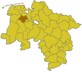
Ammerland is a district in
Lower Saxony ,Germany . It is bounded by (from the east and clockwise) the city ofOldenburg and the districts of Oldenburg, Cloppenburg, Leer, Friesland andWesermarsch .History
The "Ammerland" was first mentioned in the 10th century. The word is believed to derive from "Ameri", which is an old word meaning "swamp". In the time of
Viking raids small ring-like castles were built in order to protect the defenceless hamlets.For many years there was little interest in this swampy region. In the 14th century it became part of the
County of Oldenburg . The counts established strongholds in the region, which was the frontier against the lands of the untamableFrisia ns.The district was established in 1933 in the rough borders of the historical region.
Geography
Ammerland is characterised by a very flat countryside, many fens and swamps, and lots of
windmill s. The latter are a symbol of the district, which calls itself sometimes the "land of windmills".The central point of the district is the
Zwischenahner Meer located near the resort town ofBad Zwischenahn , a lake with an area of 5.5 km² ("Meer" is the German word for "sea", but in the localLow German , as in Dutch, it means "lake").Coat-of-arms
Cities and municipalities
External links
* [http://www.ammerland.de/ Official website] de icon
* [http://www.ammerland-touristik.de/ Touristical website] de icon
Wikimedia Foundation. 2010.