Rotenburg (district)

Rotenburg (district)

Infobox German district noregbez
name=Rotenburg
state=Lower Saxony
capital=Rotenburg
area=2070
population=163,900
population_as_of=2003
density=79
carsign=ROW
url= [http://www.landkreisrotenburgwuemme.de landkreisrotenburgwuemme.de]

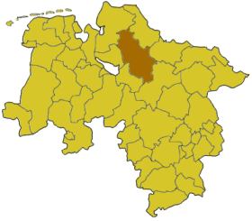
Rotenburg is a district ("Landkreis") in Lower Saxony, Germany. It is bounded by (from the north and clockwise) the districts of Stade, Harburg, Soltau-Fallingbostel, Verden, Osterholz and Cuxhaven.

History

In medieval times the region was part of the bishoprics of Bremen and Verden. After the Protestant Reformation the bishoprics became secular principalities and finally parts of the Kingdom of Hanover.

The present district was established in 1977 by merging the former districts of Rotenburg and Bremervörde.

Geography

The Wümme River runs through the district from east to west. The marshy area to both sides of the river is called the Wümmeniederung ("Wümme plains").

Coat of arms

External links

* [http://www.landkreisrotenburgwuemme.de/ Official website] (German)


Wikimedia Foundation. 2010.

Игры ⚽ Поможем решить контрольную работу

Look at other dictionaries:

  • Rotenburg an der Fulda — Les berges de la Fulda …   Wikipédia en Français

  • District De Cassel — Regierungsbezirk Kassel Données générales …   Wikipédia en Français

  • District de Kassel — District de Cassel District de Cassel Regierungsbezirk Kassel Données générales …   Wikipédia en Français

  • District de cassel — Regierungsbezirk Kassel Données générales …   Wikipédia en Français

  • Rotenburg (Wümme) — Pour les articles homonymes, voir Rotenburg. Rotenburg an der Wümme …   Wikipédia en Français

  • Rotenburg an der Fulda — Infobox German Location Art = Stadt Name = Rotenburg a.d. Fulda image photo = Historische haeuser rotenburg.jpg imagesize = 250px image caption = Old houses in Rotenburg, facing the Fulda River Wappen = Wappen Rotenburg an der Fulda.png lat deg …   Wikipedia

  • Rotenburg an der Wümme — Infobox German Location Art = Town image photo = Rotenburg Rathaus.jpg image caption = Town hall Wappen = Wappen Rotenburg (Wümme).png lat deg = 53 |lat min = 06 |lat sec = 25 lon deg = 09 |lon min = 23 |lon sec = 49 Lageplan = Bundesland = Lower …   Wikipedia

  • Rotenburg (arrondissement) — Arrondissement de Rotenburg (Wümme) Arrondissement de Rotenburg (Wümme) Landkreis Rotenburg (Wümme) …   Wikipédia en Français

  • District de Cassel — 51° 10′ N 9° 25′ E / 51.17, 9.42 …   Wikipédia en Français

  • Cassel (district) — District de Cassel District de Cassel Regierungsbezirk Kassel Données générales …   Wikipédia en Français

Share the article and excerpts

Direct link
Do a right-click on the link above
and select “Copy Link”