- Deir Abu Da'if
-
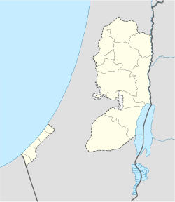
Deir Abu Da'if Other transcription(s) – Arabic دير ابو ضعيف Location of Deir Abu Da'if within the Palestinian territories Coordinates: 32°27′21.30″N 35°21′56.65″E / 32.455917°N 35.3657361°ECoordinates: 32°27′21.30″N 35°21′56.65″E / 32.455917°N 35.3657361°E Governorate Jenin Government – Type Municipality Population (2006) – Jurisdiction 5,293 Deir Abu Da'if (Arabic: دير ابو ضعيف) is a Palestinian village in the West Bank, located 6 km east of the city of Jenin in the northern West Bank. According to the Palestinian Central Bureau of Statistics, the town had a population of 5,293 inhabitants in mid-year 2006.[1]
Deir Abu Da'if municipality is inhibited by three main families; Al Yaseen, AlMahameed, Al Aliyat who are originally came from the city of Al-Khalil (Hebron) about 500 years ago.
External links
Cities 

Municipalities Ajjah · Arrabah · Burqin · Deir Abu Da'if · Jaba · Kafr Dan · Kafr Rai · Meithalun · Silat ad-Dhahr · Silat al-Harithiya · Yabad · Al-Yamun · Zababdeh ·Villages 'Anin · Anzah · al-Attara · Araqah · Arranah · Barta'a ash-Sharqiyah · Bir al-Basha · Dahiyat Sabah al-Kheir · Deir Ghazaleh · Fahma · Fandaqumiya · Faqqua · Jalamah · Jalbun · Jalqamus · Kufeirit · al-Manshiyya · Mirka · Misilyah · al-Mughayyir · Nazlet Zeid · Rummanah · Sanur · ash-Shuhada · Sir · at-Tayba · Ti'inik · Tura al-Gharbiya · Umm ar-Rihan · Umm at-Tut · ZububaCategories:- Jenin Governorate
- Palestine geography stubs
- Towns in the West Bank
Wikimedia Foundation. 2010.

