- Denmark, Iowa
-
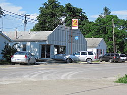
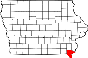
Denmark, Iowa — Unincorporated community — Denmark, Iowa Location within the state of Iowa Coordinates: 40°44′30″N 91°20′15″W / 40.74167°N 91.3375°WCoordinates: 40°44′30″N 91°20′15″W / 40.74167°N 91.3375°W Country United States State Iowa County Lee Elevation 722 ft (220 m) Time zone Central (CST) (UTC-6) – Summer (DST) CDT (UTC-5) ZIP codes 52624 FIPS code GNIS feature ID 455882[1] Denmark is an unincorporated community in northeastern Lee County, Iowa, United States. It lies along Iowa Highway 16 north of the city of Fort Madison, the county seat of Lee County.[2] Its elevation is 722 feet (220 m).[1] Although Denmark is unincorporated, it has a post office, with the ZIP code of 52624,[3] which opened on 1846-04-07.[4] The community is part of the Fort Madison–Keokuk, IA-MO Micropolitan Statistical Area.
See also
- Denmark Congregational United Church of Christ, listed on the National Register of Historic Places in Iowa
References
- ^ a b "Denmark, Iowa". Geographic Names Information System, U.S. Geological Survey. http://geonames.usgs.gov/pls/gnispublic/f?p=gnispq:3:::NO::P3_FID:455882.
- ^ Rand McNally. The Road Atlas '08. Chicago: Rand McNally, 2008, p. 39.
- ^ Zip Code Lookup
- ^ U.S. Geological Survey Geographic Names Information System: Denmark Post Office
Municipalities and communities of Lee County, Iowa Cities Donnellson | Fort Madison | Franklin | Houghton | Keokuk | Montrose | St. Paul | West Point
Unincorporated
communitiesArgyle | Charleston | Denmark | New Boston | Pilot Grove | Wever
Categories:- Iowa geography stubs
- Populated places in Lee County, Iowa
- Unincorporated communities in Iowa
- Fort Madison-Keokuk micropolitan area
Wikimedia Foundation. 2010.


