- DeRidder, Louisiana
-
City of DeRidder City 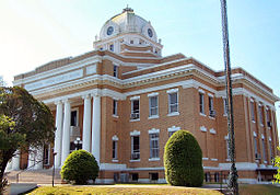 Beauregard Parish Courthouse
Country United States State Louisiana Parishes Beauregard, Vernon Elevation 203 ft (61.9 m) Coordinates 30°51′05″N 93°17′25″W / 30.85139°N 93.29028°W Area 8.5 sq mi (22 km2) - land 8.5 sq mi (22 km2) - water 0.0 sq mi (0 km2), 0% Population 9,808 (2000) Density 1,155.4 / sq mi (446.1 / km2) Incorporated 1903 Mayor "Ron" Roberts Timezone CST (UTC-6) - summer (DST) CDT (UTC-5) ZIP code 70634 Area code 337 
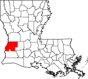
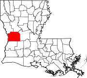
 Location of DeRidder in Louisiana
 Location of Louisiana in the United States
Website: cityofderidder.org DeRidder is a city in and the parish seat of Beauregard Parish, Louisiana, United States.[1] The population was 9,808 at the 2000 census. A small portion of the city extends into Vernon Parish.
DeRidder is the smaller principal city of the Fort Polk South-DeRidder CSA, a Combined Statistical Area that includes the Fort Polk South (Vernon Parish) and DeRidder (Beauregard Parish) micropolitan areas,[2][3] which had a combined population of 85,517 at the 2000 census.[4]
Contents
History
DeRidder was named for Ella de Ridder, the sister-in-law of a Dutch railroad financier. Her family originally came from the small town of Geldermalsen in the Netherlands, where she was one of 13 children. She ran away from home at an early age, and was presumed dead by her family who only recently discovered that she had traveled to the United States. The town was named for her by her brother in law, who brought the first railroad to that area of Louisiana.
Prior to that the little town was known as Schovall and DeRidder. The first train line to serve DeRidder came in 1902. It was the Pittsburgh & Gulf Railroad - later called the Kansas City Southern.
The July 26, 1924 DeRidder Enterprise stated: "The first house in DeRidder was made of logs and covered with board shingles, split by hand from the logs of the forest. It was constructed in 1893 and was the old homestead house of Calvin Shirley, who was the original owner of the land upon which the first business house and residence of DeRidder were built. Mr. Shirley homesteaded the 160 acres (0.65 km2) which was later platted and became the original townsite of DeRidder."
According to Eva Stewart Frazar, whose family came to DeRidder near the turn of the century, "The largest pine in the world grew where DeRidder now stands - or so it is claimed by timber men who knew."
About the origin of the town, she says, "...the Kansas City railroad was built from Kansas City to Port Arthur - and came right through here about 1896. By 1898 the trains were running. The post-office was named Miersburg for the postmaster whose name was Miers. The railroad workers had used this spot for a camping place for the workmen - and people wanted to get near the railroad - so 160 acres (0.65 km2) of land was bought for the town site.
"Immediately following the purchase of the town site, a ramble of rough houses were hurriedly built out of rough lumber... By 1898 the town consisted of nearly 300 people and a number of shack homes and a sawmill. C. Landry and Mr. George Heard had a hotel. There were about 5 small stores, besides. West Brothers had a Rous Racket store on the east side of the track."
By this time DeRidder had a sawmill, and timber was the prime industry of the area. The Longleaf Pine was the primary tree used in the industry. In 1903, DeRidder was finally incorporated as a town.
In April 1904, a large portion of the business section of DeRidder was destroyed by fire. The cause was apparently arson. A Grand Jury collected enough evidence for this to indict George Smith, a gambler, with setting the fire. The man reportedly left town.
DeRidder's first bank opened in 1906. On October 15, 1912, DeRidder was voted the parish seat of Beauregard Parish. The Beauregard Parish Court House and the Beauregard Parish Jail (see below) were built in 1914.
Geography
DeRidder is located at 30°51′5″N 93°17′25″W / 30.85139°N 93.29028°W (30.851419, -93.290230)[5] and has an elevation of 203 feet (61.9 m)[6].
According to the United States Census Bureau, the city has a total area of 8.5 square miles (22 km2), of which, 8.5 square miles (22 km2) of it is land and 0.1 square miles (0.26 km2) of it (0.70%) is water.
Transportation
Culture
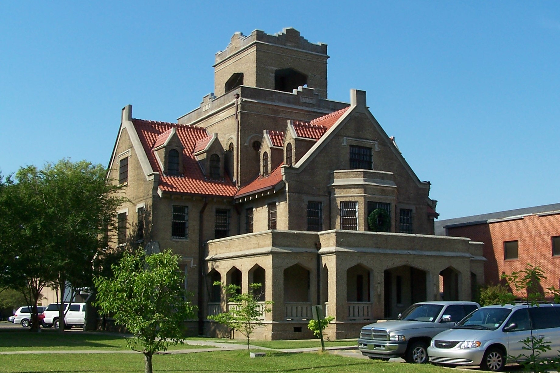
The "Hanging Jail"
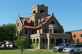 The former Beauregard Parish Jail
The building known as the "Old Beauregard Parish Jail" is a structure that is known to be one of the most distinctive of its type in the US. The Gothic-looking structure has the characteristics of the collegiate Gothic architectural style with shallow arches, dormer windows, and central tower. This style was popular with colleges, universities and churches. The iron bars in most of the windows give the structure an eerie appearance. Inside, there is a spiral staircase that leads up to three floors of jail cells. Another history-making fact is that each cell had a toilet, shower, lavatory and window. When the jail was in use, prisoners could often be seen waving from the barred windows.
It was built to house 50 or so prisoners, but held 13 in comfort. The walls are 13 to 21 in (0.33 to 0.53 m) thick, made of reinforced concrete with a blasted finish. The first floor has quarters for the jailer and his family. In the jail's basement, a long corridor leads to the courthouse next door.
In 1928, there was a famous double execution by hanging in the jail for two murderers.[7] These were the only recorded hangings in the jail. The prisoners were hanged by an apparatus at the top of the spiral staircase. After this the jail became known as "The hanging jail".
This unique jail was used until 1982, when a court action forced it to close. However, on October 4, 1981 it was put on the National Register of Historic Places, along with several other buildings in DeRidder.
Demographics
As of the census[4] of 2000, there were 9,808 people, 3,819 households, and 2,616 families residing in the city. The population density was 1,155.4 people per square mile (446.0/km²). There were 4,454 housing units at an average density of 524.7 per square mile (202.6/km²). The racial makeup of the city was 60.81% White, 34.73% African American, 0.57% Native American, 1.42% Asian, 0.03% Pacific Islander, 0.57% from other races, and 1.88% from two or more races. Hispanic or Latino of any race were 2.40% of the population.
There were 3,819 households, out of which 33.3% had children under the age of 18 living with them, 48.6% were married couples living together, 16.9% had a female householder with no husband present, and 31.5% were non-families. 28.1% of all households were made up of individuals and 11.7% had someone living alone who was 65 years of age or older. The average household size was 2.48 and the average family size was 3.03.
In the city of DeRidder, the population was spread out with 27.1% under the age of 18, 8.6% from 18 to 24, 27.3% from 25 to 44, 22.4% from 45 to 64, and 14.5% who were 65 years of age or older. The median age was 37 years. For every 100 females, there were 89.2 males. For every 100 females age 18 and over, there were 83.3 males.
The median income for a household in the city was $31,952, and the median income for a family was $39,384. Males had a median income of $36,388 versus $21,302 for females. The per capita income for the city was $16,996. About 15.0% of families and 18.0% of the population were below the poverty line, including 22.1% of those under age 18 and 18.2% of those age 65 or over.
Education
Beauregard Parish School Board operates local public schools.
For the city of DeRidder these schools are:
Grades 9 - 12 DeRidder High School [1] (DeRidder)
Grades 6 - 8 DeRidder Junior High School (DeRidder)
Grades 4 & 5 Pine Wood Elementary School (DeRidder)
Grades 2 & 3 G. W. Carver Elementary School (DeRidder)
PreK - 1st Grade K. R. Hanchey Elementary School (DeRidder)
Notable people
- Joe M. Aguillard (president of Louisiana College in Pineville; former Beauregard Parish school superintendent)
- Mel Branch (College/Professional Football Player -LSU/Dallas Texans/Kansas City Chiefs/Miami Dolphins)
- Chris Cagle (football)
- Chris Cagle (country music singer)
- Rusty Hamer (former child actor who committed suicide in DeRidder in 1990)
- Johnny Jones (College/College Head Basketball coach - LSU/Head coach at University of North Texas)
- Michael Sanders (College/NBA basketball player - UCLA/Kansas City Kings/Cleveland Cavaliers)
- Jennifer Weiner (author)
- H.O. West (founder of West Brothers clothing stores)
References
- ^ "Find a County". National Association of Counties. http://www.naco.org/Counties/Pages/FindACounty.aspx. Retrieved 2011-06-07.
- ^ MICROPOLITAN STATISTICAL AREAS AND COMPONENTS, Office of Management and Budget, 2007-05-11. Accessed 2008-08-01.
- ^ COMBINED STATISTICAL AREAS AND COMPONENT CORE BASED STATISTICAL AREAS, Office of Management and Budget, 2007-05-11. Accessed 2008-08-01.
- ^ a b "American FactFinder". United States Census Bureau. http://factfinder.census.gov. Retrieved 2008-01-31.
- ^ "US Gazetteer files: 2010, 2000, and 1990". United States Census Bureau. 2011-02-12. http://www.census.gov/geo/www/gazetteer/gazette.html. Retrieved 2011-04-23.
- ^ "US Board on Geographic Names". United States Geological Survey. 2007-10-25. http://geonames.usgs.gov. Retrieved 2008-01-31.
- ^ Beauregard Parish Jailhanging referenced.
External links
- City of DeRidder
- Beauregard Parish History
- Historic DeRidder: Downtown Walking Tour, a pamphlet published by the Beauregard Tourist Commission (June 2000).
Municipalities and communities of Beauregard Parish, Louisiana Parish seat: DeRidderCity DeRidder‡
Town CDP Longville
Unincorporated
communitiesFootnotes ‡This populated place also has portions in an adjacent parish or parishes
Municipalities and communities of Vernon Parish, Louisiana Cities DeRidder‡ | Leesville
Towns Villages CDPs Unincorporated
communitiesBurr Ferry | Coopers | Evans | Fullerton | Hicks | Lacamp | Pickering | Pitkin | Sandy Hill | Slagle
Footnotes ‡This populated place also has portions in an adjacent parish or parishes
Categories:- Cities in Louisiana
- Parish seats in Louisiana
- Populated places in Beauregard Parish, Louisiana
- Populated places in Vernon Parish, Louisiana


Wikimedia Foundation. 2010.