- Dry Creek, Louisiana
-
Dry Creek Unincorporated community 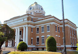 Beauregard Parish Courthouse
Country United States State Louisiana Parishes Beauregard, Vernon Elevation 104 ft (31.7 m) Coordinates 30°40′10″N 93°2′42″W / 30.66944°N 93.045°W Area 2.5 sq mi (6.5 km2) - land 2.5 sq mi (6 km2) - water 0.0 sq mi (0 km2), 0% unincorporated ---- Government Beauregard Paris Police Jury Timezone CST (UTC-6) - summer (DST) CDT (UTC-5) ZIP code 706 Area code 337 
 Location of Dry Creek in Louisiana
 Location of Louisiana in the United States
Dry Creek is a rural unincorporated community in the east-central portion of Beauregard Parish, Louisiana, United States. It lies 20 miles southeast of Deridder on the corner of LA 113 and LA 394. It is 104 feet above sea level.The geography of the area is slightly hilly, ranging from 80 to 135 feet above sea level, consisting of mostly sandy soils with many creeks (not all dry) and ponds.
Dry Creek is at the beginning of the "piney woods" of central Louisiana. Logging is the major industry of the area. There are many extraordinary vegetable gardens, and the entire area is noted for Sugartown melons as well as a "family atmosphere".
Children in the area attend East Beauregard Elementary School and East Beauregard High School, five miles north.
Contents
Bundick Lake
Bundick Lake is located approximately five miles north/northwest of "downtown" Dry Creek and is source of recreation for locals as well as others from all over the parish.
Dry Creek Baptist Camp
Dry Creek Baptist Camp is located at the corner of the two highways across from the only grocery store in the community, with a Pentecostal Church on the north side and a Bible Church on the south side of its boundary. There are many churches in the area and all faiths utilize the Camp's facilities. drycreek.net is the official website of the camp.
History
The earlier settlers to the area would have encountered one of two Indian tribes, probably Coushatta, descended from the Atakapas. One was located on Dry Creek and the other near Sugartown.
Dry Creek School
Referred to as the "White House", the Dry Creek School is an imposing neo-Greco building that alters one's concept of the traditional country school. Built in 1912, the wings and columns of the building were added in 1919-1920. The school was the first to support public education through taxes. A victim of school consolidation, it closed in 1962 when the Sugartown school and the Dry Creek school consolidated, was renamed East Beauregard School, and was relocated 5 miles north.
NRHP
The building was listed on the National Register of Historic Places[1] January 28, 1988.
Municipalities and communities of Beauregard Parish, Louisiana Parish seat: DeRidder City 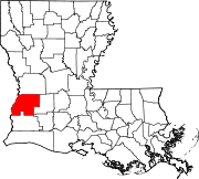
Town CDP Longville
Unincorporated
communitiesDry Creek | Sugartown
Footnotes ‡This populated place also has portions in an adjacent parish or parishes
References
- ^ National Register of Historic Places -List of historic places in Louisiana
Categories:- Populated places in Beauregard Parish, Louisiana
- Unincorporated communities in Louisiana
- National Register of Historic Places in Louisiana


Wikimedia Foundation. 2010.