- Fort Polk South-DeRidder combined statistical area
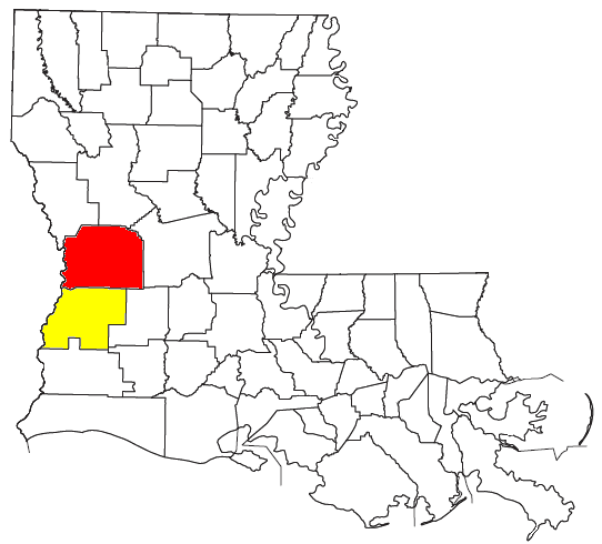
thumb|right|300px|Location of the Fort Polk South-DeRidder CSA and its components:The Fort Polk South-DeRidder Combined Statistical Area is made up of two parishes in centralLouisiana . The statistical area consists of the Fort Polk South Micropolitan Statistical Area and the DeRidder Micropolitan Statistical Area. As of the 2000 census, the CSA had a population of 85,517 (though a July 1, 2007 estimate placed the population at 82,156). [cite web | url = http://www.census.gov/popest/metro/tables/2007/CBSA-EST2007-02.csv | title = Table 2. Annual Estimates of the Population of Combined Statistical Areas: April 1, 2000 to July 1, 2007 (CBSA-EST2007-02) | format = CSV | work = 2007 Population Estimates | publisher =United States Census Bureau , Population Division | date =2008-03-27 | accessdate = 2008-09-20]Parishes
Communities
*Places with more than 10,000 inhabitants
**Fort Polk South (Principal city andcensus-designated place )*Places with 5,000 to 10,000 inhabitants
**DeRidder (Principal city)
**Leesville*Places with 1,000 to 5,000 inhabitants
**Fort Polk North (census-designated place)
**Merryville
**New Llano
**Rosepine*Places with less than 1,000 inhabitants
**Anacoco
**Hornbeck
**SimpsonDemographics
As of the
census GR|2 of 2000, there were 85,517 people, 30,364 households, and 22,791 families residing within the CSA. The racial makeup of the CSA was 77.77% White, 15.46% African American, 1.15% Native American, 1.20% Asian, 0.21% Pacific Islander, 1.65% from other races, and 2.56% from two or more races. Hispanic or Latino of any race were 4.19% of the population.The median income for a household in the CSA was $31,899, and the median income for a family was $36,283. Males had a median income of $30,860 versus $20,028 for females. The
per capita income for the CSA was $14,775.ee also
*
List of cities, towns, and villages in Louisiana References
Wikimedia Foundation. 2010.