- Nukus
-
Nukus
Uzbek: Nukus / Нукус
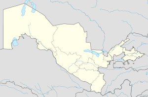
Karakalpak: No‘kis / НөкисThe Savitsky Karakalpakstan Art Museum at Nukus Location in Uzbekistan Coordinates: 42°28′N 59°36′E / 42.467°N 59.6°E Country  Uzbekistan
Province  Karakalpakstan
Population (2004 est.) – Total 260,000 Nukus (Uzbek: Nukus / Нукус; Karakalpak: No‘kis / Нөкис; Russian: Нукус) is the sixth-largest city in Uzbekistan, and the capital of the autonomous Karakalpakstan Republic. It has a population of 260,000 (2004 estimate). The Amu Darya river passes west of the town.
The city is best known for its world-class Nukus Museum of Art.
Contents
History
Nukus developed from a small settlement in 1932 into a large, modern Soviet city with broad avenues and big public buildings by the 1950s. The city's isolation made it host to the Red Army's Chemical Research Institute, a major research and testing center for chemical warfare weapons.
Environmental concerns
With the fall of the Soviet Union and the growing environmental disaster of the Aral Sea, the city's situation has deteriorated. Contamination of the surrounding area by wind-borne salt and pesticides from the dry Aral Sea bed have turned the surrounding area into a wasteland, with very high rates of respiratory disorders, cancer, birth defects and deformities.
Sights
Nukus is host to the Nukus Museum of Art (also known as the State Art Museum of the Republic of Karakalpakstan, named after Igor V. Savitsky) and State Museum. The State Museum houses the usual collection of artifacts recovered from archaeological investigations, traditional jewelry, costumes and musical instruments, but more interestingly, displays of the area's now vanished or endangered flora and fauna, and on the Aral Sea issue. The Art Museum is noted for its collection of modern Russian and Uzbek art from 1918-1935. Stalin tried his best to eliminate all non Soviet art from this period, and sent most of the artists to the gulag. Both Savitsky himself and the collection at Nukus survived because of the city's remoteness.[1]
Nukus is also home to the Progress Center, Central Asia's finest English-language institute. Housed in a former Komsomol meeting hall, the institute has received major funding from UNICEF.[2]
Climate
Nukus experiences a desert climate (Köppen BWk) with summers that are long, dry and very hot, and winters that are short, though quite cold.
Climate data for Nukus Month Jan Feb Mar Apr May Jun Jul Aug Sep Oct Nov Dec Year Average high °C (°F) −0.3
(31.5)1.9
(35.4)10.6
(51.1)21.0
(69.8)28.7
(83.7)33.8
(92.8)36.0
(96.8)33.3
(91.9)27.5
(81.5)18.1
(64.6)10.2
(50.4)2.6
(36.7)18.62
(65.51)Average low °C (°F) −8.8
(16.2)−7.9
(17.8)−0.8
(30.6)7.6
(45.7)13.9
(57.0)18.3
(64.9)20.8
(69.4)18.1
(64.6)11.8
(53.2)4.3
(39.7)−0.7
(30.7)−5.2
(22.6)5.95
(42.71)Precipitation mm (inches) 10.1
(0.398)8.7
(0.343)16.4
(0.646)19.3
(0.76)12.2
(0.48)3.9
(0.154)3.5
(0.138)2.1
(0.083)3.0
(0.118)8.7
(0.343)9.4
(0.37)13.6
(0.535)110.9
(4.366)Avg. precipitation days 9.5 7.6 8.9 9.0 6.1 3.6 2.8 1.7 2.4 4.9 6.1 9.7 72.3 Source: World Meteorological Organisation (UN) [3] Notes
- ^ Tom Bissell, Chasing the Sea, Pantheon (2003). ISBN 0375421300. p. 323–324.
- ^ Bissell, Chasing the Sea, p. 325–326.
- ^ "World Weather Information Service – Nukus". United Nations. http://worldweather.wmo.int/032/c00118.htm. Retrieved 05 January 2011.
See also
External links
Coordinates: 42°28′N 59°36′E / 42.467°N 59.6°E
 KarakalpakstanCapital: Nukus
Districts and seats Amudaryo District (Mang‘it) · Beruniy District (Beruniy) · Chimboy District (Chimboy) · Ellikqala District (Bo‘ston) · Kegeyli District (Kegeyli) · Mo‘ynoq District (Mo‘ynoq) · Nukus District (Oqmang‘it) · Qonliko‘l District (Qanliko‘l) · Qo‘ng‘irot District (Qo‘ng‘irot) · Qorao‘zak District (Qorao‘zak) · Shumanay District (Shumanay) · Taxtako‘pir District (Taxtako‘pir) · To‘rtko‘l District (To‘rtko‘l) · Xo‘jayli District (Xo‘jayli)
 Cities of Uzbekistan
Capital Cities Andijan • Angren • Asaka • Bekabad • Beruniy • Bukhara • Chimboy • Chirchiq • Fergana • Guliston • G‘ijduvon • G‘uzor • Jizzakh • Juma • Kattaqo‘rg‘on • Kogon • Kosonsoy • Margilan • Mo‘ynoq • Namangan • Navoiy • Nukus • Nurota • Olmaliq • Qarshi • Qorako‘l • Qorasuv • Qo‘ng‘irot • Qo‘qon • Rishton • Samarkand • Shahrisabz • Shirin • Sirdaryo • Termez • To‘rtko‘l • To‘ytepa • Uchquduq • Urganch • Urgut • Vobkent • Xiva • Xo‘jayli • Yangiabad • Yangiyer • Yangiyo‘l • ZarafshonCategories:- Populated places in Uzbekistan
Wikimedia Foundation. 2010.


