- Chesapeake & Delaware Canal Bridge
-
Chesapeake & Delaware Canal Bridge 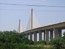
Official name Senator William V. Roth, Jr. Bridge Other name(s) New St. Georges Bridge Carries  DE 1 (6 lanes)
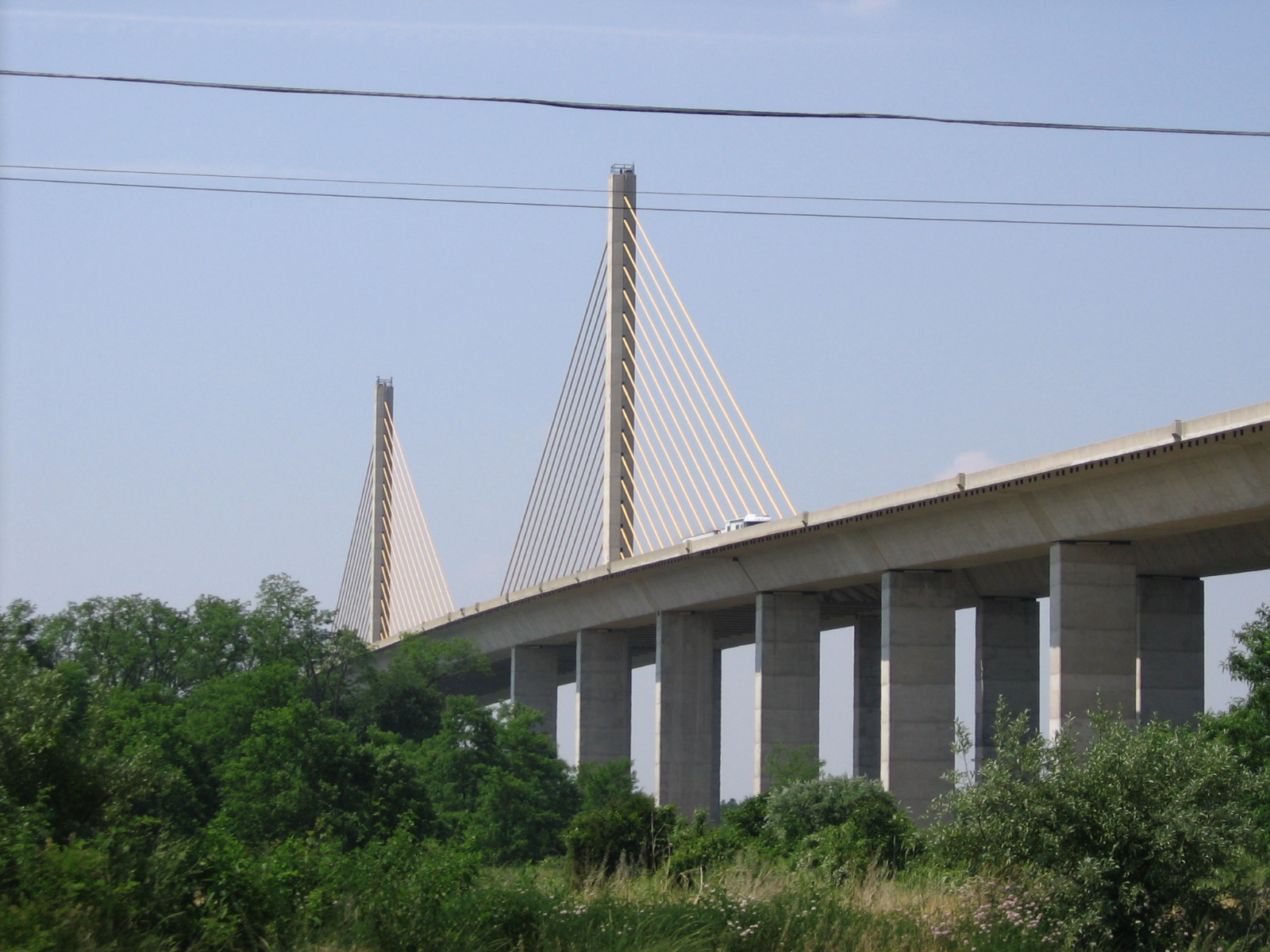
Crosses Chesapeake & Delaware Canal Locale St. Georges, Delaware Maintained by U.S. Army Corps of Engineers Design Cable-stayed bridge Total length 4,650 feet (1,417 m) Width 127 feet (39 m) Longest span 750 feet (229 m) Clearance below 100 feet (30.5 m) Construction begin 1991 Construction end 1994 Opened December 23, 1995 Coordinates 39°32′59″N 75°39′23″W / 39.549722°N 75.656501°W The Chesapeake & Delaware Canal Bridge (officially the Senator William V. Roth, Jr. Bridge) is a concrete and steel cable-stayed bridge that spans the Chesapeake & Delaware Canal near St. Georges, Delaware. The bridge is located near a tolled section of Delaware Route 1 that runs parallel to the St. Georges Bridge carrying U.S. Highway 13. In November 2006, the bridge was named after U.S. Senator William V. Roth, Jr., who not only lent his name to the Roth IRA, but was instrumental in securing federal funding to build the bridge. It is owned and operated by the U.S. Army Corps of Engineers and does not carry a toll, despite the location of a nearby toll plaza.
Contents
History
The idea of the C & D Canal Bridge came about in the late 1980s when former Governor Michael N. Castle investigated a new canal crossing to replace the aging St. Georges Bridge. Originally, the plan was to use the four-lane bridge as part of the planned "Dover Extension" of the Delaware Turnpike, but local opposition to the plan forced Delaware officials to look at a new location. Although different plans were looked at, the final plan, using a concrete bridge was approved in 1989.
Shortly after construction began on the "Route 7 Relocation" the present-day Tybouts Corner-Delaware Turnpike section of Delaware Route 1, construction began on the bridge in 1992, with the excavation of the nearby site, located just one mile west of the corporate limit of St. Georges. The two halves were joined at the center in early 1994 and the bridge opened in December, 1995 when the Tybouts Corner-Biddles Corner section of Delaware Route 1 was completed.
After its opening, the Corps of Engineers rerouted U.S. Highway 13 onto the new bridge and for a few years, closed the old St. Georges Bridge, with the intent of demolishing it. After local opposition, the old St. Georges Bridge was rehabilitated with new lead-free paint, new roadway deck, and several joint and structural repairs that allows medium weight trucks, for local deliveries, to use the old crossing. A new exit for U.S. 13 and Lorewood Grove Road, which connects St. Georges with Summit was opened after the rehabilitation project was completed.
As a stipulation in keeping both bridges open, and in the case that the older St. Georges Bridge is in need of repair or replacement, no tolls are charged on the C & D Canal Bridge. The new exit for U.S. 13/Lorewood Grove Road serves as the "last chance" exit before the Biddle Corner toll plaza for Delaware Rt. 1.
Physical Description
The C & D Canal Bridge, the first cable-stayed bridge of its type in the Delaware Valley area (all previous Delaware River or C & D Canal bridges are either suspension, cantilever, or simple truss designs), is also the first pre-cast concrete bridge to be built in the United States. Modeled after that of the Sunshine Skyway Bridge in St. Petersburg, Florida, the bridge incorporates many features not found on the other canal bridges:
- Fixed high-level crossing, a 100 feet (30 m) clearance like that of the other Canal highway crossings.
- 750 feet (229 m) center span, with the major anchorages out of the water (thus preventing a catastrophic collision similar to the old Sunshine Skyway Bridge and previous C & D Canal bridges)
- six travel lanes, with the option of restriping to eight
- pull-off emergency shoulders on both sides (under the current striping arrangement)
- roadway lighting – they were removed in 2003 at the requests of canal pilots and replaced with low-voltage low-pressure sodium floodlights that illuminate the main support anchors
- 65-mph speed limit
- separate approach spans, only joining at the anchorages of the cables
The bridge also incorporates a 3% climbing grade, a feature lacked on the nearby St. Georges Bridge. The bridge, built between 1991 and 1994, utilized pre-cast concrete segments that were made in Baltimore, Maryland, and transported by barge until it reached the job site. Once at the site, the segments were fitted into place like that of a jigsaw puzzle.
See also
- List of crossings of the Cheasapeake & Delaware Canal
- List of largest cable-stayed bridges
External links
Bridges of the Chesapeake & Delaware Canal West
Chesapeake & Delaware Canal Lift Bridge
Norfolk SouthernChesapeake & Delaware Canal Bridge
East
St. Georges Bridge
 Categories:
- Cable-stayed bridges in the United States
- Bridges completed in 1995
- Intracoastal Waterway
- Buildings and structures in New Castle County, Delaware
- Transportation in New Castle County, Delaware
- Road bridges in Delaware
Wikimedia Foundation. 2010.