- California State Route 68
-
State Route 68
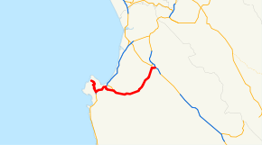
Route information Defined by S&HC § 368 Maintained by Caltrans Length: 22.02 mi[1] (35.44 km) Major junctions West end: Asilomar State Beach in Pacific Grove  SR 1 in Monterey
 SR 218 near Del Rey Oaks
East end:  US 101 in Salinas
Highway system State highways in California(list • pre-1964)
History • Unconstructed • Deleted • Freeway • Scenic←  SR 67
SR 67SR 70  →
→State Route 68 (SR 68) is a state highway that runs from Pacific Grove to Salinas in Monterey County. It is about 20 miles (32 km) long.
Contents
Route description
This route is part of the California Freeway and Expressway System[2] and is eligible for the State Scenic Highway System.[3] However, only the part from SR 1 to the Salinas River is designated by Caltrans as a scenic highway.[4] The Monterey-Salinas Highway is a California Scenic Route because of its views of the chaparral and springtime lupin for 14 miles (23 km) between State Route 1 in Monterey to the Salinas River.[citation needed] State Route 68 is part of the Juan De Anza Trail.[5]
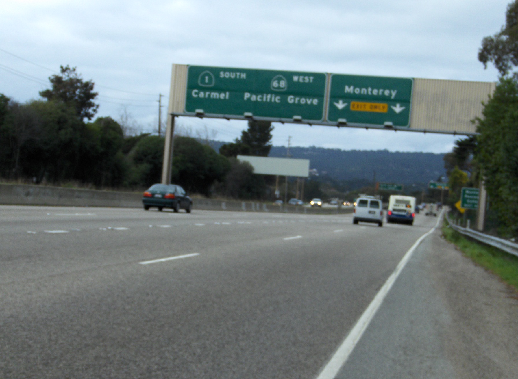
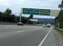 State Route 68 westbound concurrent with State Route 1 southbound in Monterey.
- Highway 68 is heavily traveled. The road has a design capacity of 16,000 vehicles per day. As of 2006, it carries about 26,000 vehicles per day. This figure is projected to increase as residential development in and around Salinas continues, and the Monterey Peninsula's tourism economy continues to expand.
- The Monterey-Salinas Highway is the main connector between Monterey and Salinas. [1]
- The Holman Highway is the main connector between Pacific Grove and Carmel.[2]
- Traffic backs up on Highway 68 in the morning and afternoon since many people that work on the Monterey Peninsula live in Salinas, and vice versa.
- Highway 68 and the "68" road symbol have become iconic in Pacific Grove skating culture. This association developed after the opening of the skate shop "68 Skate".
Highway names
- Asilomar Boulevard - Start to Sunset Drive.
- Sunset Drive - For about 1/2 mile up a hill from the coast.
- Forest Avenue - Goes past multiple businesses, becomes Holman Hwy.
- W.R. Holman Highway - Pacific Grove to junction with State Route 1.
- Cabrillo Highway - Route 68 is synonymous with Route 1 for 2.5 miles (4.0 km).
- Monterey-Salinas Highway - Route 68 exits Route 1 and continues for 17 miles (27 km) to Salinas. Goes past Monterey Peninsula Airport, Pasadera, Mazda Raceway Laguna Seca, Laureles Grade, Corral De Tierra, San Benancio, Toro Park and Spreckels. Freeway for first 1/2 mile and last 3 miles (4.8 km).
- South Main Street - Monterey-Salinas becomes South Main at Salinas City Limits and continues to downtown.
- John Street - Route 68 makes a right off of Main and follows John St. to its terminus at U.S. Route 101.
History
Highway 68 is part of the DeAnza Trail, a route that linked all of California's mission settlements during the Spanish colonial period. With the advent of the automobile, Highway 68 was upgraded from a dirt wagon road to a 2-lane paved road in 1937.[6]
During the 1950s and 1960s, Caltrans had planned to upgrade Highway 68 to a freeway between Salinas and Highway 1 in Monterey, that was to start at US 101 south of the city and proceed west between Salinas and Spreckels, serving as a bypass for Salinas. The freeway was to then follow the existing Highway 68 alignment into Monterey.
The freeway plan died as a result of environmental concerns along the route. The only portions of this freeway that were actually built were a 1-mile (1.6 km) section approaching the Highway 1 interchange in Monterey, and a 3-mile (4.8 km) segment starting in Spreckels and heading west, bypassing the unincorporated village of Toro Park. The segment around Spreckels opened in 1967 and included a pair of new bridges spanning the Salinas River, which replaced an old truss bridge built in 1889. At the western terminus of the Spreckels freeway segment, land acquired for the freeway can still be seen.[7]
There continues to be discussions, but no definitive plans, to either bypass Route 68 or convert the existing road to 4-lanes by building a second roadway alongside the present 2-lane carriageway. Caltrans and Monterey County officials mention the most practical route for a bypass would be to the north of the existing Route 68, through Fort Ord. A major upgrade of the Highway 68 corridor would cost on the order of $300 million. In the fall of 2007, Caltrans is scheduled to begin a $6 million project to implement safety upgrades at three major intersections along Highway 68.
Meanwhile, Caltrans and Monterey County are proceeding with a plan to divert Monterey-Salinas traffic away from Highway 68 by converting Davis Road and Reservation Road from two lanes to four between Highway 101 on the north side of Salinas and Highway 1 in Marina. These two roads pass through Fort Ord and the upgrades are using excess land set aside following the base's closure in 1994. The Davis Road/Reservation Road upgrade is a short-term fix, and most state and county officials realize that a permanent fix for Highway 68 will eventually be necessary.
Major intersections
- Note: Except where prefixed with a letter, postmiles were measured in 1964, based on the alignment as it existed at that time, and do not necessarily reflect current mileage.
The entire route is in Monterey County.
Location Postmile
[8][9][10]Exit
[11][12]Destinations Notes Pacific Grove 0.00 Sinex Avenue – Asilomar State Beach 17-Mile Drive Monterey L4.26
75.14[N 1] SR 1 south / 17-Mile Drive – CarmelInterchange; west end of SR 1 overlap West end of freeway on SR 1 R75.75[N 1] 399B Munras Avenue – Monterey No eastbound entrance R76.00[N 1] 399C Soledad Drive, Munras Avenue Westbound exit and eastbound entrance R77.38[N 1] 401A Aguajito Road – Monterey R78.12[N 1]
R3.957B SR 1 north – Santa Cruz, San FranciscoEast end of SR 1 overlap R3.99 7B North Fremont Street – Seaside No eastbound entrance; signed as exit 401B eastbound East end of freeway Del Rey Oaks 6.81 SR 218 west (Canyon del Rey Road) / Monterra Road – Del Rey Oaks, Seaside11.22  CR G20 (Laureles Grade) – Carmel Valley
West end of freeway 15.83 19 Portola Drive R17.19 20  CR G17 (River Road, Reservation Road)
R18.08 21 Spreckels Boulevard East end of freeway Salinas 19.97 Blanco Road to US 10122.02 US 101Interchange 22.02 John Street Continuation beyond US 101 1.000 mi = 1.609 km; 1.000 km = 0.621 mi
Concurrency terminus • Closed/Former • Incomplete access • UnopenedReferences
- ^ January 1, 2006 California Log of Bridges on State Highways
- ^ CA Codes (shc:250-257)
- ^ CA Codes (shc:260-284)
- ^ "Officially Designated State Scenic Highways and Historic Parkways". California Department of Transportation. December 7, 2007. http://www.dot.ca.gov/hq/LandArch/scenic_highways/. Retrieved June 22, 2011.
- ^ Trails and Roads: De Anza Trail last retrieved March 6, 2007.
- ^ California Highway 68, America's Lost Roads
- ^ A TROUBLED BEAUTY Highway 68: A road with scenery, history and tragedy, The Salinas Californian, August 4, 2007
- ^ California Department of Transportation, State Truck Route List (XLS file), accessed February 2008
- ^ California Department of Transportation, Log of Bridges on State Highways, July 2007
- ^ California Department of Transportation, All Traffic Volumes on CSHS, 2005 and 2006
- ^ California Department of Transportation, California Numbered Exit Uniform System, State Route 68 Freeway Interchanges, Retrieved on 2009-02-06.
- ^ California Department of Transportation, California Numbered Exit Uniform System, State Route 1 Freeway Interchanges, Retrieved on 2009-02-06.
External links
Categories:- State highways in California
- Juan Bautista de Anza National Historic Trail
- Freeways in California
- Roads in Monterey County, California
- Scenic highways in California


Wikimedia Foundation. 2010.