- Mangatarem, Pangasinan
-
Mangatarem — Municipality — 
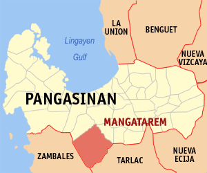
SealMap of Pangasinan showing the location of Mangatarem. Location in the Philippines
 Mangatarem
Coordinates: 15°47′N 120°18′E / 15.783°N 120.3°ECoordinates: 15°47′N 120°18′E / 15.783°N 120.3°E Country  Philippines
Region Ilocos Region (Region I) Province Pangasinan District 2nd District, Pangasinan Founded 1837 Barangays 82 Government – Mayor Teodoro Cruz Area – Total 317.50 km2 (122.6 sq mi) Population (2007) – Total 65,366 – Density 205.9/km2 (533.2/sq mi) Time zone PST (UTC+8) ZIP code 2413 Income class 2nd class; partly urban dito sinilang si hesika Population Census of Mangatarem Census Pop. Rate 1995 53,603 — 2000 60,943 2.79% 2007 65,366 0.97% Mangatarem is a 2nd class and largest municipality (in terms of land area) in the province of Pangasinan, Philippines. According to the latest census, it has a population of 65,366 people in 11,704 households.
Mangatarem is a Pangasinan word for "mango plantation".
Barangays
Mangatarem is politically subdivided into 82 barangays.
- Andangin
- Arellano Street (Pob.)
- Bantay
- Bantocaling
- Baracbac
- Peania Pedania (Bedania)
- Bogtong Bolo
- Bogtong Bunao
- Bogtong Centro
- Bogtong Niog
- Bogtong Silag
- Buaya
- Buenlag
- Bueno
- Bunagan
- Bunlalacao
- Burgos Street (Pob.)
- Cabaluyan 1st
- Cabaluyan 2nd
- Cabarabuan
- Cabaruan
- Cabayaoasan
- Cabayugan
- Cacaoiten
- Calumboyan Norte
- Calumboyan Sur
- Calvo (Pob.)
- Casilagan
- Catarataraan
- Caturay Norte
- Caturay Sur
- Caviernesan
- Dorongan Ketaket
- Dorongan Linmansangan
- Dorongan Punta
- Dorongan Sawat
- Dorongan Valerio
- General Luna (Pob.)
- Gomez (Pob.)
- Historia
- Lawak Langka
- Linmansangan
- Lopez (Pob.)
- Mabini (Pob.)
- Macarang
- Malabobo
- Malibong
- Malunec(original)
- Maravilla (Pob.)
- Maravilla-Arellano Ext. (Pob
- Muelang
- Naguilayan East
- Naguilayan West
- Nancasalan
- Niog-Cabison-Bulaney
- Olegario-Caoile (Pob.)
- Olo Cacamposan
- Olo Cafabrosan
- Olo Cagarlitan
- Osmeña (Pob.)
- Pacalat
- Pampano
- Parian
- Paul
- Pogon-Aniat
- Pogon-Lomboy (Pob.)
- Ponglo-Baleg
- Ponglo-Muelag
- Quetegan (Pogon-Baleg)
- Quezon (Pob.)
- Salavante
- Sapang
- Sonson Ongkit
- Suaco
- Tagac
- Takipan
- Talogtog
- Tococ Barikir
- Torre 1st
- Torre 2nd
- Torres Bugallon (Pob.)
- Umangan
- Zamora (Pob.)
External links
References
Municipalities - Agno
- Aguilar
- Alcala
- Anda
- Asingan
- Balungao
- Bani
- Basista
- Bautista
- Bayambang
- Binalonan
- Binmaley
- Bolinao
- Bugallon
- Burgos
- Calasiao
- Dasol
- Infanta
- Labrador
- Laoac
- Lingayen
- Mabini
- Malasiqui
- Manaoag
- Mangaldan
- Mangatarem
- Mapandan
- Natividad
- Pozorrubio
- Rosales
- San Fabian
- San Jacinto
- San Manuel
- San Nicolas
- San Quintin
- Santa Barbara
- Santa Maria
- Santo Tomas
- Sison
- Sual
- Tayug
- Umingan
- Urbiztondo
- Villasis
Component cities - Alaminos
- San Carlos
- Urdaneta
Independent component city (Administratively independent from the province, but grouped under Pangasinan by the National Statistics Office)Categories:- Municipalities of Pangasinan


Wikimedia Foundation. 2010.