- Olango Island Group
-
Olango Island Group Native name: Olango 
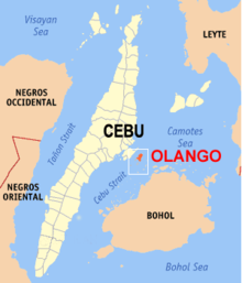
Geography Location Cebu Province Coordinates 10°16′N 124°03′E / 10.267°N 124.05°E Archipelago Philippine Archipelago Total islands 7[1] Major islands Olango Island[1] Area 10.3 km2 (3.98 sq mi) Country PhilippinesLocal Government Unit City, Municipality City Lapu-Lapu City Municipality Municipality of Cordova PhilippinesCity Lapu-Lapu City Mayor Paz C. Radaza PhilippinesMunicipality Municipality of Cordova Mayor Adelino Sitoy Demographics Population 21,928 [2] (as of 1995) Density 3,420 /km2 (8,860 /sq mi) The Olango Island Group is a group of islands found in the Central Visayas region of the Philippines. It is composed of Olango Island and 6 satellite islets namely: Sulpa, Gilutongan, Nalusuan, Caohagan, Pangan-an, and Camungi. Olango Island and its neighboring islets has a total land area of approximately 10.3 square kilometres (4.0 sq mi). The island group is under the jurisdiction of the City of Lapu-Lapu and the Municipality of Cordova. The island group is a part of Cebu Province. It lies 5 km east of Mactan Island and a major tourist destination in Cebu.[3] It is known for its wildlife sanctuary.
Contents
Geography
The Olango Group of islands consists of seven islands. It lies between 10°16′N latitude and 124°03′E longitude. Located five kilometers east of Mactan Island, Olango Island and its satellite islets lies between the Bohol Strait to the south and the Camotes Sea to the north. To the east is the Olango Channel while to the west is the Gilutungan Channel.[4]
Land area
Olango Island and its neighboring islets has a total land area of approximately 10.3 km² (1,030 hectares).[1] The reef flat-lagoon surrounding the island of Olango is considered one of the most extensive reef areas in the Central Visayas.[1] A total of 4,482 hectares[1] of extensive sandy beach, rocky shoreline, inshore flats, seagrass beds, coral reefs, mangrove forest, mudflats, and salt marsh grass surround Olango and its satellite islets.
Topography
The Olango group of islands is an island group composed of the island of Olango and six satellite islets. The six neighboring islets namely: Sulpa, Gilutongan, Nalusuan, Caohagan, Pangan-an, and Camungi are bounded by continuous fringing reefs[1] (steep reef wall on the west and sloping reef at the east coast of Olango) and reef flats. The islands are low-lying with elevation reaching no more than 10 meters above sea level.[1] At the center of these islands is a vast tidal flat, which includes the 920-hectare area[1] of the Olango Island Wildlife Sanctuary.
Geology
Olango Island and its satellite islets are raised coral reefs.[1] The lithology of the island consists of 2 unit types: the Plio-Pleistocene Carcar Formation and the Quaternary Alluvium (the youngest lithologic unit). Carcar formation is typically a porous coralline limestone characterized by small sinkholes, pitted grooves, and branching pinnacles. This suggests in situ deposition.[1] Its dominant composition are shell, algae, and other carbonate materials, while macro and micro fossils are found abundant in its formation. Alluvium, on the other hand, is mostly found in the coastal areas. Calcareous sand derived from the weathering of limestone mostly makes up the tidal flat. This appears as fine to coarse-grained sand mixed with shell fragments.[1]
Climate
The Philippines has two seasons namely: the wet and dry seasons. The dry season typically occurs from February to May and the rainy season from June to January. The dry season may be subdivided further into the cool dry season, from December to February; and the hot dry season, from March to May.[5]
Olango Island has a tropical climate, which is typical to the Central Visayas region of the Philippines.[1] According to the Philippine Atmospheric, Geophysical and Astronomical Services Administration (PAGASA), the area is relatively hot and humid, with a mean daily temperature range of 23 to 30 degrees Celsius. Daily mean relative humidity ranges from 60 to 94 percent. The annual rainfall averages about 1,579 mm at Mactan-Cebu International Airport and 1,440 mm in Barangay Maribago, which is located along the eastern coastline of Mactan Island.[1]
The climate of Olango Island can be classified as Type 3, having a very pronounced maximum rain period and only a short dry season.[1] Although, the Philippine archipelago lies within the typhoon belt,[6] the island of Olango is shielded from typhoons by the islands of Mactan and Bohol.
Political/administrative boundaries
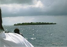 Caohagan Island
Olango and its satellite islets are under the jurisdiction of 2 local government units (LGUs), namely, the City of Lapu-Lapu and the Municipality of Cordova. The Olango Island group is composed of 11 barangays.[3] The main island of Olango is composed of 8 barangays (Baring, Caw-oy, Sabang, Santa Rosa, Talima, Tingo, Tungasan and San Vicente) as well as the island barangays of Pangan-an and Caohagan,[2] which are under the administration of Lapu-Lapu City. Gilutongan and Nalusuan Islands both within Barangay Gilutongan,[2] are under the jurisdiction of the Municipality of Cordova.
Demographics
Population size, density, distribution
Olango and its satellite islets had a total population of 21,928, composed of 4,382 households in 1995.[7] The average population density of Olango is 34.2 individuals per ha or 3,420 per km2, with Gilutongan Island having the highest density of all the barangays at 96.8 individuals per hectare.[2] In 2009, the total population has reached 32,000 people.
Education
Elementary schools are found in all barangays and 4 high schools operating in 4 barangays. At present, there are no college or vocational courses being offered in the island.[2]
Source of income
The traditional occupations of Olango residents are fishing[8] and coastal-related activities such as shellcraft,[8] aquarium fish collection, boat operations, and seaweed farming. Other sources of income include rainfed farming, personnel services, livestock raising, small enterprise (sari-sari store) and, recently, various types of employment from tourism activities.[2]
Olango Island Wildlife Sanctuary
Olango Island is a diverse coastal ecosystem consisting of extensive coralline sandflats, mangroves, seagrass beds, and offshore coral reefs. The island's mangroves are most extensive in the Cebu province, and its offshore corals are home to scores of various marine species. The island is virtually flat, and it is surrounded by warm seas and partly sheltered from monsoons and strong trade winds.[9]
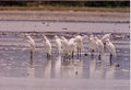
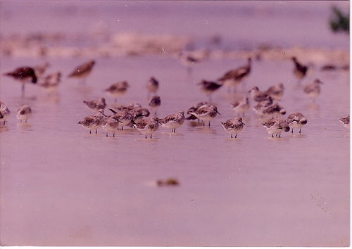
Olango Island, situated off Mactan Island in Cebu, is one of the seven best-known flyways in the world for migrating birds. Its main attraction is its 920-hectare Olango Island Wildlife Sanctuary,[10] a haven for migratory birds from Siberia, Northern China, and Japan. These birds flock to the island seeking refuge from the winter climate of other countries.[11] The sanctuary supports the largest concentration of migratory birds found so far in the Philippines. There are 97 species of birds in Olango, 48 of which are migratory species, while the rest are resident birds of the island.[12]
The birds use Olango as a major refueling station as well as a wintering ground. The birds stop by the island on their southward journey to Australia and New Zealand and on their journey back to their nesting grounds. Among the frequent guests are Chinese egrets, Asiatic dowitchers, Eastern curlews, plovers, sanpipers,[13] Black-tailed Godwit and Red Knot.[12] It is best to visit Olango around the months of July to November just in time for winter in the Northern Hemisphere.
Then President Corazon Aquino declared the 1,020 hectares tidal flats in Olango a protected area under Proclamation No. 903[10] on May 14, 1992.[10] It was included on the Ramsar List of Wetlands of International Importance on 1 July 1994.[10] It is the Philippines' first wetland of international importance for waterfowl.[12]
Dive sites
The island of Olango is also known for its dive sites.[9] Tourists can dive in three[14] different sites around the island.
Situated in the northern tip of the island is Mabini Point. Descending to around 35m at the drop-off, one can watch sharks, including hammerheads and the occasional whale shark.[15] Currents around the site are strong and unpredictable.[14]
Olango Island has one of the deepest wall dives around.[9] Baring is along the North-Western side of the island and the wall starts at 60 ft/20m and ends down to about 220 ft/73m before disappearing on a gradual slope. Grey reef sharks, tuna, barracuda, snappers and jacks can be found around the area.[14]
Slightly further south is Santa Rosa. The dive starts with a sandy bottom covered in soft corals, leading to a drop-off at 15m, descending to 50m. There is a good variety of reef fish in the shallows here, while further down you'll see fusiliers, catfish, jacks, snappers and sweetlips, among others.[14]
Photographs
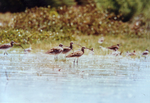
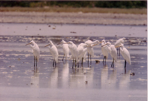
Birds in Olango Wildlife Sanctuary
-
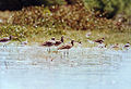
Eastern Curlews
Numenius madagascariensis -
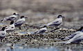
Little Terns
Sternula albifrons -
Chinese Egrets
Egretta eulophotes -

Asiatic Dowitchers
Limnodromus semipalmatus
References
- ^ a b c d e f g h i j k l m n "Physical and Oceanographic Features". Coastal Environmental Profile of Olango Island, Cebu, Philippines. http://oneocean.org/download/20010629/olango_profile/chap2.pdf. Retrieved 2008-07-14.
- ^ a b c d e f "Socio-Political Profile". Coastal Environmental Profile of Olango Island, Cebu, Philippines. http://oneocean.org/download/20010629/olango_profile/chap4.pdf. Retrieved 2008-07-14.
- ^ a b "At Olango, Challenge Spells Opportunity". Overseas: The Online Magazine for Sustainable Seas. http://www.oneocean.org/overseas/feb99/at_olango_challenge_spells_opportunity.html. Retrieved 2008-07-14.
- ^ "Olango Island". Malapascua Island: Visayan Sea, Cebu, Philippines. http://www.malapascua.de/Cebu/Olango_Island/hauptteil_olango_island.html. Retrieved 2008-07-14.
- ^ "The Seasons". Climate of the Philippines. Archived from the original on 2008-07-12. http://web.archive.org/web/20080712160005/http://www.pagasa.dost.gov.ph/cab/climate.htm. Retrieved 2008-07-14.
- ^ "Climate in Cebu: Straight, uncensored information from those who live in Cebu". Living in Cebu. http://www.livingincebu.com/climate.htm. Retrieved 2008-07-14.
- ^ NSO (National Statistics Office). 1995. The 1995 socio-economic and demographic characteristics. 550 p.
- ^ a b "Olango Island". K.I. Marine Sports Center, Cebu. http://www.cebucruising.com/cebu-olango-mactan-olongo-island.html. Retrieved 2008-07-14.
- ^ a b c "About Olango Island and the Visayas". Polaris Dive Center. http://www.polaris-dive.com/eng_nf/olango.htm. Retrieved 2008-07-14.
- ^ a b c d "Wetlands in the Philippines". Society for the Conservation of Philippine Wetlands, Inc.. Archived from the original on 2008-04-06. http://web.archive.org/web/20080406073122/http://www.psdn.org.ph/wetlands/olango.htm. Retrieved 2008-07-14.
- ^ "Caring for Olango Island and its People". Olango Area Resource Management Program. http://www.pbsp.org.ph/olango_intro.html. Retrieved 2008-07-14.
- ^ a b c "PGMA's Olango Wetlands visit accents RP's anti-bird flu campaign". The Official Government Portal of the Republic of the Philippines. http://www.gov.ph/cat_localgov/newscontent.asp?newsid=13719. Retrieved 2008-07-14.
- ^ "Olango Island". Ecotourism Philippines. http://www.ecotourismphilippines.com/default2.php?site=22. Retrieved 2008-07-14.[dead link]
- ^ a b c d "Olango Island, Mactan, Philippines". Asia Dive Site. http://www.asiadivesite.com/philippines-dive-sites/mactan/olango-island.php. Retrieved 2008-07-14.
- ^ "Eastern Cebu and Mactan Island". Intas Travel. http://www.intas-travel.com/diving/dive_locations/cebu_1.html. Retrieved 2008-07-14.
External links
Categories:- Visayan Islands
- Cebu
-


Wikimedia Foundation. 2010.