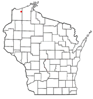
- Brule, Wisconsin
-
Brule, Wisconsin — Town — Location of Brule, Wisconsin Coordinates: 46°33′58″N 91°35′39″W / 46.56611°N 91.59417°W Country United States State Wisconsin County Douglas Area – Total 55.9 sq mi (144.7 km2) – Land 55.7 sq mi (144.3 km2) – Water 0.2 sq mi (0.5 km2) Elevation[1] 1,093 ft (333 m) Population (2000) – Total 591 – Density 10.6/sq mi (4.1/km2) Time zone Central (CST) (UTC-6) – Summer (DST) CDT (UTC-5) ZIP code 54820 Area code(s) 715 and 534 FIPS code 55-10575[2] GNIS feature ID 1582879[1] Website www.brule-wi.org Brule is a town in Douglas County, Wisconsin, United States. The population was 591 at the 2000 census. The town takes its name from the nearby Bois Brule River, which flows north into Lake Superior. The census-designated place of Brule and unincorporated communities of Bellwood and Winneboujou are located in the town of Brule.
Contents
Transportation
U.S. Highway 2 and Wisconsin Highway 27 are two of the main arterial routes in the community.
Brule is located between the cities of Superior and Ashland on U.S. Highway 2.
History
The Town of Brule was founded on November 13, 1886.[3]
The Brule River is one of the preeminent trout streams in North America, with abundant native and migratory steelhead, brown, and brook trout. Located near the primary trout spawning bed for western Lake Superior, Brule is a destination for serious fly fishermen from the around the world.
Four United States presidents, Calvin Coolidge, Herbert Hoover, Harry Truman, and Dwight Eisenhower, have summered near Brule in some of the many Adirondack-style lodges erected by prominent families from Minneapolis and Milwaukee.[4]
In 1899, Professor Ulysses Sherman Grant, of Northwestern University, inspected the Brule, Wisconsin area for ancient copper deposits.[5]
Geography
According to the United States Census Bureau, the town has a total area of 55.9 square miles (144.7 km²), of which, 55.7 square miles (144.3 km²) of it is land and 0.2 square miles (0.5 km²) of it (0.32%) is water.
Brule is located 6.5 miles east–northeast of Lake Nebagamon; 30 miles east of the city of Superior; and 35 miles west of the city of Ashland.
Demographics
As of the census[2] of 2000, there were 591 people, 244 households, and 165 families residing in the town. The population density was 10.6 people per square mile (4.1/km²). There were 270 housing units at an average density of 4.8 per square mile (1.9/km²). The racial makeup of the town was 98.14% White, 1.18% Native American, and 0.68% from two or more races. Hispanic or Latino of any race were 1.02% of the population.
There were 244 households out of which 30.3% had children under the age of 18 living with them, 56.1% were married couples living together, 7.4% had a female householder with no husband present, and 32.0% were non-families. 28.7% of all households were made up of individuals and 12.7% had someone living alone who was 65 years of age or older. The average household size was 2.42 and the average family size was 2.97.
In the town the population was spread out with 27.1% under the age of 18, 4.1% from 18 to 24, 28.1% from 25 to 44, 26.4% from 45 to 64, and 14.4% who were 65 years of age or older. The median age was 39 years. For every 100 females there were 105.2 males. For every 100 females age 18 and over, there were 105.2 males.
The median income for a household in the town was $35,972, and the median income for a family was $40,078. Males had a median income of $32,250 versus $20,000 for females. The per capita income for the town was $14,620. About 8.1% of families and 12.4% of the population were below the poverty line, including 20.7% of those under age 18 and none of those age 65 or over.
References
- ^ a b "US Board on Geographic Names". United States Geological Survey. 2007-10-25. http://geonames.usgs.gov. Retrieved 2008-01-31.
- ^ a b "American FactFinder". United States Census Bureau. http://factfinder.census.gov. Retrieved 2008-01-31.
- ^ Brule, Town of, Douglas Co
- ^ Welcome to Brule
- ^ Wisconsin's Ancient Copper Miners
External links
Coordinates: 46°33′11″N 91°34′36″W / 46.55306°N 91.57667°W
Municipalities and communities of Douglas County, Wisconsin City Villages Lake Nebagamon | Oliver | Poplar | Solon Springs | Superior
Towns CDPs Brule | Gordon
Unincorporated
communitiesAnton | Bellwood | Bennett | Black River | Blueberry | Borea | Boylston | Boylston Junction | Carnegie | Chaffey | Cloverland | Cozy Corner | Dairyland | Dedham | Dewey | Dobie | Foxboro | Hawthorne | Hillcrest | Hines | Maple | Moose Junction | Parkland | Patzau | Pokegama | South Range | Sunnyside | Wascott | Wentworth | Winneboujou
Categories:- Towns in Douglas County, Wisconsin
Wikimedia Foundation. 2010.


