- Christoval, Texas
-
Christoval, Texas — CDP — Location of Christoval, Texas
Coordinates: 31°11′38″N 100°29′39″W / 31.19389°N 100.49417°WCoordinates: 31°11′38″N 100°29′39″W / 31.19389°N 100.49417°W Country United States State Texas County Tom Green Area – Total 1.2 sq mi (3.1 km2) – Land 1.2 sq mi (3.1 km2) – Water 0.0 sq mi (0.0 km2) Elevation 2,037 ft (621 m) Population (2000) – Total 422 – Density 348.4/sq mi (134.5/km2) Time zone Central (CST) (UTC-6) – Summer (DST) CDT (UTC-5) ZIP code 76935 Area code(s) 325 FIPS code 48-14872[1] GNIS feature ID 1354482[2] Christoval is a census-designated place (CDP) in Tom Green County, Texas, United States. The population was 422 at the 2000 census. It is part of the San Angelo, Texas Metropolitan Statistical Area.
Contents
Geography
Christoval is located at 31°11′38″N 100°29′39″W / 31.19389°N 100.49417°W (31.193947, -100.494115).[3] It is situated approximately twenty miles south of San Angelo in southern Tom Green County around the area of Loop 110, U.S. Highway 277, and FM 2084.[4]
According to the United States Census Bureau, the CDP has a total area of 1.2 square miles (3.1 km²), all of it land.
The South Concho River runs through Christoval, and serves as a water supply to the surrounding area. It was the location of a resort from the 1930s to the early 1960s, near where U.S. 277 crosses the river.
History
The community, which has also been known as South Concho and Delong, is said to be named after early settler Christopher Columbus Doty. A post office was established in 1889 and a local school was operating by 1901. By 1914, Christoval had an estimated population of 200, two general stores, and a newspaper – the Christoval Observer. Through the 1930s, a Baptist encampment was held annually that attracted as many as 10,000 persons to the South Concho River area and the mineral waters in nearby Christoval also attracted visitors and settlers.
On September 17, 1936 a devastating flood hit the South Concho River. The flood destroyed the Baptist encampment facility, and parts of Christoval. Several people were killed in the flood, as they were swept away by the rapidly rising water. Following the flood, the encampment facilities were never rebuilt, and the property eventually became a public park.
Playland Park was a popular local attraction from the 1950s through the 1980s. The park offered public access to the river, as well as boat rentals, a rope bridge, tree swings, and a concession stand. At its peak in the 1970s, the facility had amusement park rides and a small train. The facility was closed in the 1980s due to liability concerns and smaller crowds. Today, Pugh Park offers public access to the South Concho River.
The population peaked at around 500 in the 1930s before declining to approximately 400 in the mid-1950s and 200 by the mid-1970s. The rerouting of U.S. Highway 277 in 1987 was expected to bring a further decline, but the population was not significantly impacted by the change. In 2000, a total of 29 businesses were operating in Christoval.[5]
Christoval is the hometown of actor Colby Donaldson, of Survivor fame.
Local Attractions
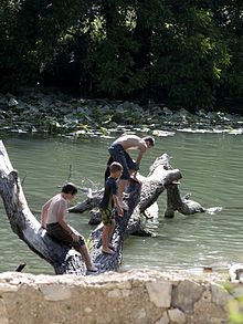 Swimmers at Pugh Park
The South Concho River runs through Christoval, and approximately 0.75 miles of riverfront are part of a public park. The shoreline in this area is covered by large oak trees, and the trees have rope swings for visitors. This park, known as Pugh Park, has visitors from across West Texas each weekend. Crowds of over 500 people are not uncommon on the weekends in the summer.
Public access to the South Concho River is also available at the Mineral Wells crossing, about a mile north of Christoval.
Each Memorial Day Weekend, the community of Christoval holds Old Toenail Trail days, which attracts visitors from around the region. Festivities include live music, parades, and food and craft vendors.
Demographics
As of the census[1] of 2000, there were 422 people, 167 households, and 124 families residing in the CDP. The population density was 348.4 people per square mile (134.7/km²). There were 218 housing units at an average density of 180.0 per square mile (69.6/km²). The racial makeup of the CDP was 92.18% White, 0.47% African American, 1.18% Native American, 5.21% from other races, and 0.95% from two or more races. Hispanic or Latino of any race were 14.45% of the population.
There were 167 households, of which 38.3% had children under the age of 18 living with them, 51.5% were married couples living together, 19.8% had a female householder with no husband present, and 25.7% were not families; 22.2% of all households were made up of individuals, and 7.8% had someone living alone who was 65 years of age or older. The average household size was 2.53 and the average family size was 2.96.
In the CDP, the population distributed as 30.6% under the age of 18, 5.5% from 18 to 24, 25.1% from 25 to 44, 24.4% from 45 to 64, and 14.5% who were 65 years of age or older. The median age was 40 years. For every 100 females, there were 99.1 males. For every 100 females age 18 and over, there were 86.6 males.
The median income for a household in the CDP was $26,750, and the median income for a family was $32,292. Males had a median income of $28,750 versus $24,688 for females. The per capita income for the CDP was $13,257. About 12.6% of families and 18.3% of the population were below the poverty line, including 25.4% of those under age 18 and 10.2% of those age 65 or over.
Education
Public education in the community of Christoval is provided by the Christoval Independent School District.
References
- ^ a b "American FactFinder". United States Census Bureau. http://factfinder.census.gov. Retrieved 2008-01-31.
- ^ "US Board on Geographic Names". United States Geological Survey. 2007-10-25. http://geonames.usgs.gov. Retrieved 2008-01-31.
- ^ "US Gazetteer files: 2010, 2000, and 1990". United States Census Bureau. 2011-02-12. http://www.census.gov/geo/www/gazetteer/gazette.html. Retrieved 2011-04-23.
- ^ "Christoval, Texas". Texas Escapes Online Magazine. http://www.texasescapes.com/TexasTowns/Christoval-Texas.htm. Retrieved 2009-06-15.
- ^ "Christoval, Texas". The Handbook of Texas online. http://www.tshaonline.org/handbook/online/articles/CC/hlc32.html. Retrieved 2009-06-15.
Links
- Christoval, Texas community website.
- History of the Christoval Baptist Encampment
- Christoval Church
Municipalities and communities of Tom Green County, Texas City 
CDPs Christoval | Grape Creek
Unincorporated
communitiesCarlsbad | Harriett | Knickerbocker | Mereta | Orient | Tankersley | Vancourt | Veribest | Wall | Water Valley
Ghost town Categories:- Populated places in Tom Green County, Texas
- Census-designated places in Texas
- San Angelo metropolitan area


Wikimedia Foundation. 2010.