- Shire of Avon
Infobox Australian Place | type = lga
name = Shire of Avon
state = vic
region =
area = 2533
est = 1864
seat = Stratford
pop = 4360 (1992) [cite book|title=Victorian Year Book|author=Australian Bureau of Statistics, Victoria Office|year=1994|page=49-52|id=ISSN 0067-1223]
logosize =
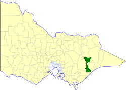
caption = Location in Victoria
county = Tanjil, Dargo, Wonnangatta
near-nw = Maffra
near-n = Bright
near-ne = Omeo
near-w = Maffra
near-e = Bairnsdale
near-sw = Sale (C)
near-s = Rosedale
near-se = Rosedale
_noautocat = yes:"This article is about a local government area in Victoria. For the Western Australian region, see
Avon Valley or its component shires of York, Northam and Beverley."The Shire of Avon was a Local Government Area located about convert|20|km|mi|0 north of Sale, the major regional centre in central
Gippsland , Victoria,Australia . The shire covered an area of convert|2533|km2|sqmi|1, and existed from 1864 until 1994.History
Avon was first incorporated as a district on 13 September 1864, and became a shire on 10 October 1865. On 27 May 1914 and 1 October 1964, it annexed parts of the
Shire of Bairnsdale , and on 2 May 1917 it annexed part of the eastern riding of theShire of Maffra . During 1966 and 1967, parts of its area were annexed to theCity of Sale .cite book|title=Victorian Municipal Directory|year=1992|publisher=Arnall & Jackson|location=Brunswick|pages=573-574 Accessed atState Library of Victoria , La Trobe Reading Room.]On 2 December 1994, the Shire was abolished, and merged with
Shire of Alberton ,Shire of Maffra ,City of Sale and most ofShire of Rosedale into theShire of Wellington . [cite book|url=http://www.ausstats.abs.gov.au/ausstats/free.nsf/0/76E601D6DB55E88ACA25722500049195/$File/12570_1994-95.pdf|title=Victorian local government amalgamations 1994-1995: Changes to the Australian Standard Geographical Classification|author=Australian Bureau of Statistics |date=1 August 1995|publisher=Commonwealth of Australia|page=12|isbn=0-642-23117-6|accessdate=2008-01-05]Wards
Avon was divided into three ridings, each of which elected three councillors:
* South Riding
* Central Riding
* North RidingTowns and Localities
Population
* Estimate in the 1958 Victorian Year Book.
References
Wikimedia Foundation. 2010.