- Shire of Alberton
Infobox Australian Place | type = lga
name = Shire of Alberton
state = vic
region =
area = 1868.83
est = 1855
seat = Yarram
pop = 6430 (1992) [cite book|title=Victorian Year Book|author=Australian Bureau of Statistics, Victoria Office|year=1994|page=49-52|id=ISSN 0067-1223]
logosize =
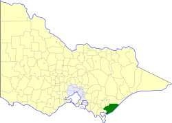
caption = Location in Victoria
county = Buln Buln
near-nw = Morwell Traralgon
near-n = Rosedale
near-ne = Rosedale
near-w = South Gippsland
near-e = "Bass Strait "
near-sw = South Gippsland
near-s = "Bass Strait "
near-se = "Bass Strait "
_noautocat = yesThe Shire of Alberton was a Local Government Area located about convert|220|km|mi|0 southeast of
Melbourne , the state capital of Victoria,Australia . The shire covered an area of convert|1868.83|km2|sqmi|1, and existed from 1855 until 1994.History
Alberton was first incorporated as a district on 6 November 1855, and became a shire on 2 February 1864. On 16 February 1894, part of it split away to become the Shire of South Gippsland. On 20 May 1914, it lost part of its North Riding to the
Shire of Rosedale .cite book|title=Victorian Municipal Directory|year=1992|publisher=Arnall & Jackson|location=Brunswick|pages=558-559 Accessed atState Library of Victoria , La Trobe Reading Room.]On 2 December 1994, the Shire was abolished, and merged with
Shire of Avon ,Shire of Maffra ,City of Sale and most ofShire of Rosedale into theShire of Wellington . [cite book|url=http://www.ausstats.abs.gov.au/ausstats/free.nsf/0/76E601D6DB55E88ACA25722500049195/$File/12570_1994-95.pdf|title=Victorian local government amalgamations 1994-1995: Changes to the Australian Standard Geographical Classification|author=Australian Bureau of Statistics |date=1 August 1995|publisher=Commonwealth of Australia|page=12|isbn=0-642-23117-6|accessdate=2008-01-05]Wards
Alberton was divided into three ridings, each of which elected three councillors:
* South Riding
* Central Riding
* North RidingTowns and Localities
Population
* Estimate in the 1958 Victorian Year Book.
References
Wikimedia Foundation. 2010.