- Shire of Traralgon
Infobox Australian Place | type = lga
name = Shire of Traralgon
state = vic
region =
area = 4650
est = 1879
seat = Traralgon
pop = 4810 (1992) [cite book|title=Victorian Year Book|author=Australian Bureau of Statistics, Victoria Office|year=1994|page=49-52|id=ISSN 0067-1223]
logosize =
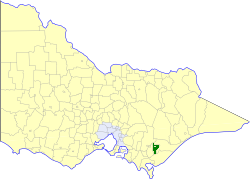
caption = Location in Victoria
county = Buln Buln, Tanjil
near-nw = Narracan
near-n = Rosedale
near-ne = Rosedale
near-w = Morwell
near-e = Rosedale
near-sw = Morwell
near-s = Alberton
near-se = Alberton
_noautocat = yesThe Shire of Traralgon was a Local Government Area located about convert|160|km|mi|0 east-southeast of
Melbourne , the state capital of Victoria,Australia . The shire covered an area of convert|4650|km2|sqmi|1, and existed from 1879 until 1994. From 1961 onwards, it did not actually administer the town of Traralgon, which was the responsibility of a separate authority.History
Traralgon was first incorporated as a shire on 24 October 1879. On 27 May 1892 it lost its western riding, which formed the
Shire of Morwell . The town of Traralgon incorporated separately as a borough on 31 May 1961, becoming theCity of Traralgon three years later.cite book|title=Victorian Municipal Directory|year=1992|publisher=Arnall & Jackson|location=Brunswick|pages=859-860 Accessed atState Library of Victoria , La Trobe Reading Room.]On 2 December 1994, the Shire was abolished, and merged with the Cities of Moe, Morwell and Traralgon, and parts of Narracan and Rosedale into the
City of Latrobe . [cite book|url=http://www.ausstats.abs.gov.au/ausstats/free.nsf/0/76E601D6DB55E88ACA25722500049195/$File/12570_1994-95.pdf|title=Victorian local government amalgamations 1994-1995: Changes to the Australian Standard Geographical Classification|author=Australian Bureau of Statistics |date=1 August 1995|publisher=Commonwealth of Australia|page=8|isbn=0-642-23117-6|accessdate=2008-01-05]Wards
Traralgon was divided into two ridings, each of which elected three councillors:
* Central Riding
* East RidingTowns and Localities
* Callignee
* Flynns Creek
* Koornalla
* Loy Yang
* Traralgon South
* Traralgon West
* TyersPopulation
* Estimate in the 1958 Victorian Year Book.
References
Wikimedia Foundation. 2010.