- Shire of Bairnsdale
Infobox Australian Place | type = lga
name = Shire of Bairnsdale
state = vic
region =
area = 2277.9
est = 1867
seat = Bairnsdale
pop = 7670 (1992) [cite book|title=Victorian Year Book|author=Australian Bureau of Statistics, Victoria Office|year=1994|page=49-52|id=ISSN 0067-1223]
logosize =
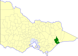
caption = Location in Victoria
county = Tanjil, Dargo, Wonnangatta
near-nw = Avon
near-n = Omeo
near-ne = Omeo
near-w = Avon
near-e = Tambo
near-sw = Rosedale
near-s = Rosedale
near-se = "Bass Strait "
_noautocat = yesThe Shire of Bairnsdale was a Local Government Area located about convert|280|km|mi|0 east of
Melbourne , the state capital of Victoria,Australia . The shire covered an area of convert|2277.9|km2|sqmi|1, and existed from 1867 until 1994. For its first hundred years it governed both Bairnsdale and the surrounding area; however, after that time, Bairnsdale had its own city government.History
Bairnsdale was first incorporated as a district on 30 April 1867, and became a shire on 14 July 1868. On 6 January 1882, what is now the
Shire of Tambo , centred on Lakes Entrance, split away from Bairnsdale. On 27 May 1914 and 1 October 1964, it lost some land to its west to theShire of Avon . On 31 May 1967, after a poll of ratepayers, the Centre Riding and parts of the East Riding severed to form the Town of Bairnsdale (which became a City in 1990). cite book|title=Victorian Municipal Directory|year=1992|publisher=Arnall & Jackson|location=Brunswick|pages=579 Accessed atState Library of Victoria , La Trobe Reading Room.]On 2 December 1994, the Shire was abolished, and merged with
City of Bairnsdale ,Shire of Orbost ,Shire of Tambo , most ofShire of Omeo and the Boole Boole Peninsula fromShire of Rosedale into theShire of East Gippsland . The West Dargo region merged into theShire of Wellington . [cite book|url=http://www.ausstats.abs.gov.au/ausstats/free.nsf/0/76E601D6DB55E88ACA25722500049195/$File/12570_1994-95.pdf|title=Victorian local government amalgamations 1994-1995: Changes to the Australian Standard Geographical Classification|author=Australian Bureau of Statistics |date=1 August 1995|publisher=Commonwealth of Australia|page=6, 12|isbn=0-642-23117-6|accessdate=2008-01-05]Wards
Bairnsdale was divided into three ridings , each of which elected three councillors:
* East Riding
* West Riding
* South RidingTowns and Localities
* Eagle Point
* Fernbank
* Iguana Creek
* Lindenow
* Lucknow
* Mount Taylor
* Paynesville
* Walba
* Wy YungPopulation
* Estimate in the 1958 Victorian Year Book.
References
Wikimedia Foundation. 2010.