- Dallas, South Dakota
-
Dallas, South Dakota — Town — Location in Gregory County and the state of South Dakota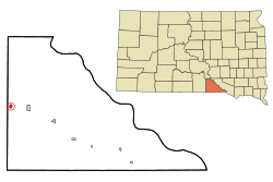
Coordinates: 43°14′13″N 99°31′0″W / 43.23694°N 99.516667°WCoordinates: 43°14′13″N 99°31′0″W / 43.23694°N 99.516667°W Country United States State South Dakota County Gregory Incorporated 1908[1] Area – Total 0.5 sq mi (1.3 km2) – Land 0.5 sq mi (1.3 km2) – Water 0 sq mi (0 km2) Elevation 2,234 ft (681 m) Population (2010) – Total 120 – Density 240/sq mi (92.3/km2) Time zone Central (CST) (UTC-6) – Summer (DST) CDT (UTC-5) ZIP code 57529 Area code(s) 605 FIPS code 46-15300[2] GNIS feature ID 1254595[3] Dallas is a town in Gregory County, South Dakota, United States. The population was 120 at the 2010 census.
Geography
Dallas is located at 43°14′13″N 99°31′0″W / 43.23694°N 99.516667°W (43.236820, -99.516582)[4].
According to the United States Census Bureau, the town has a total area of 0.5 square miles (1.3 km2), all of it land.
Dallas has been assigned the ZIP code 57529 and the FIPS place code 15300.
Demographics
As of the census[2] of 2000, there were 144 people, 59 households, and 38 families residing in the town. The population density was 286.9 people per square mile (111.2/km²). There were 68 housing units at an average density of 135.5 per square mile (52.5/km²). The racial makeup of the town was 90.28% White, 6.94% Native American, 0.69% from other races, and 2.08% from two or more races. Hispanic or Latino of any race were 0.69% of the population.
There were 59 households out of which 28.8% had children under the age of 18 living with them, 52.5% were married couples living together, 6.8% had a female householder with no husband present, and 33.9% were non-families. 25.4% of all households were made up of individuals and 16.9% had someone living alone who was 65 years of age or older. The average household size was 2.44 and the average family size was 2.95.
In the town the population was spread out with 24.3% under the age of 18, 5.6% from 18 to 24, 26.4% from 25 to 44, 22.9% from 45 to 64, and 20.8% who were 65 years of age or older. The median age was 42 years. For every 100 females there were 114.9 males. For every 100 females age 18 and over, there were 98.2 males.
The median income for a household in the town was $17,917, and the median income for a family was $18,906. Males had a median income of $17,813 versus $18,438 for females. The per capita income for the town was $11,970. There were 23.1% of families and 28.3% of the population living below the poverty line, including 31.0% of under eighteens and 32.3% of those over 64.
References
- ^ "SD Towns". South Dakota State Historical Society. http://history.sd.gov/Archives/forms/exhibits/SD%20Towns.pdf. Retrieved 2010-02-11.
- ^ a b "American FactFinder". United States Census Bureau. http://factfinder.census.gov. Retrieved 2008-01-31.
- ^ "US Board on Geographic Names". United States Geological Survey. 2007-10-25. http://geonames.usgs.gov. Retrieved 2008-01-31.
- ^ "US Gazetteer files: 2010, 2000, and 1990". United States Census Bureau. 2011-02-12. http://www.census.gov/geo/www/gazetteer/gazette.html. Retrieved 2011-04-23.
Municipalities and communities of Gregory County, South Dakota Cities 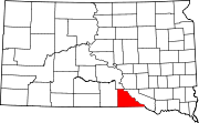
Towns CDP Indian reservation Footnotes ‡This populated place also has portions in an adjacent county or counties
Categories:- Populated places in Gregory County, South Dakota
- Towns in South Dakota


Wikimedia Foundation. 2010.