- Green Line "C" Branch
Infobox rail line
name = Green Line "C" Branch
Beacon Street Branch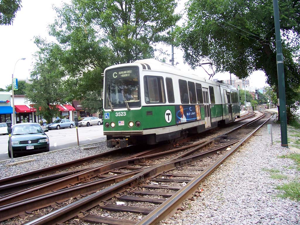
image_width = 250px
caption = Boeing Vertol USSLRV #3523 bound for Cleveland Circle, August 2005.
type =Light rail
system = MBTA
status =
locale =Greater Boston
start =North Station
end = Cleveland Circle
stations = 22
routes =
ridership = 14,522 (1995 typical weekday, surface boardings only) [http://www.bostonmpo.org/bostonmpo/resources/CMS/Entrances.pdf]
open = 1889
close =
owner = MBTA
operator = MBTA
character = Underground (Kenmore and eastward)
Grade-separated ROW (west of Kenmore)
stock =Kinki Sharyo Type 7
Ansaldobreda Type 8
linelength =
tracklength =
notrack =
gauge = RailGauge|sg
el =
speed =
elevation =The "C" Branch, also called the Beacon Street Branch or Cleveland Circle Branch, is one of the
streetcar /light rail lines that runs into theMassachusetts Bay Transportation Authority 's Green Line subway in theBoston, Massachusetts area. The surface section is in the median of Beacon Street, splitting from the "B" and "D" Branches at Kenmore before surfacing onto Beacon Street via theSt. Marys Street Incline . At the other end of the route is Cleveland Circle, a short walk from Reservoir on the "D" Branch and Chestnut Hill Avenue on the "B" Branch. On the other side of Kenmore, "C" trains run through theBoylston Street Subway andTremont Street Subway , reversing direction atNorth Station as of November 2005.Traffic Signals
As of December 2007, the traffic signals on Beacon Street in Brookline could be optimized to make the Green Line run faster, but the MBTA which would be expected to pay for the streetcar sensors does not see any benefit in coming up with the money. [http://www.boston.com/news/local/articles/2007/12/02/beacon_gets_smart_lights_but_t_isnt_along_for_the_ride] The Boston Globe has published letters from riders who are in favor of these sensors [http://www.boston.com/news/local/articles/2007/12/09/cracking_the_code_its_all_boston/] , a letter from the MBTA spokesperson arguing that a major study is needed before the MBTA spends money [http://www.boston.com/news/local/articles/2007/12/16/alderman_knows_best_a_somervillian_begs_to_differ/] , and a letter arguing that the T's spokesperson is giving too many excuses. [http://www.boston.com/news/local/articles/2007/12/30/too_many_excuses_coming_from_t_spokesman?mode=PF] As of January 2008, the MBTA is hiring a consultant to study the issue. [http://www.boston.com/news/local/articles/2008/01/27/t_may_get_edge_on_beacon_st/]
History
The first tracks on Beacon Street were laid in 1888, running from Massachusetts Avenue west to
Coolidge Corner . The next year the rest of the line to Cleveland Circle opened, with access to theReservoir Carhouse . In 1889, the first electric streetcar route (seeGreen Line "A" Branch ) used Beacon Street from Coolidge Corner east to Mass Avenue, then ran south on Mass Avenue and east on Boylston Street to Park Square. That same year the line on Beacon Street to Cleveland Circle was electrified.Another connection to the Beacon Street line was provided at Washington Square; streetcars came from Brookline Village along Washington Street and turned west on Beacon Street. This line was later extended north on Chestnut Hill Avenue and west on Commonwealth Avenue to Boston College, and was the predecessor of the MBTABus|65 bus route.
On
September 1 ,1897 , theTremont Street Subway opened, and then or soon after Beacon Street service began to run into it via theBoylston Street Portal at the Public Garden, turning around at Park Street. OnOctober 3 ,1914 , theBoylston Street Subway extended the underground portion to theKenmore Incline just east of Kenmore Square, and the underground Kenmore and theSt. Marys Street Incline extended it west onOctober 23 ,1932 .Until 1967, when it was named the "C" Branch, the Beacon Street route had the map number MBTABus|61.
Beacon Street service was extended from Park Street to Lechmere on
February 7 ,1931 . Since then, Beacon Street service has had the following east terminals:
*November 20 ,1961 : cut back from Lechmere toNorth Station all but Sundays
*March 25 ,1967 : extended to Lechmere all times
* June-September 1968: cut back to Government Center Sundays, restored to Lechmere afterwards
*March 21 ,1980 : cut back to Government Center all but rush hours
*June 21 ,1980 : extended to Lechmere all times
*April 4 ,1981 : cut back to Park Street
*June 26 ,1982 : extended to Government Center
*July 30 ,1983 : extended toNorth Station
*March 28 ,1997 : cut back to Government Center
*January 1 ,2005 : extended to North Stationtation listing
External links
* [http://www.mbta.com/traveling_t/schedules_subway_greenline_c.asp MBTA - Green Line "C" Branch map]
References
* [http://members.aol.com/eddanamta/busfiles/contents.pdf Changes to Transit Service in the MBTA district] (
PDF )
* [http://www.publictransit.us/ptlibrary/specialreports/Railopenings.pdf U.S. Urban Rail Transit Lines Opened From 1980] (PDF )
Wikimedia Foundation. 2010.