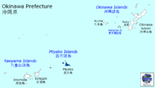
Miyako Subprefecture

Miyako Subprefecture
Miyako Subprefecture's location in Okinawa Prefecture

Miyako Subprefecture (宮古支庁 Miyako-shichō?) is a subprefecture of Okinawa Prefecture, Japan.

It includes the following cities and towns of Miyako Islands:

Offices

  • Miyako Subprefecture: 1125 Hirara Nishizato, Miyakojima-shi, Okinawa-ken. 906-0012

External links

24°47′30″N 125°17′34″E / 24.79178°N 125.292667°E / 24.79178; 125.292667Coordinates: 24°47′30″N 125°17′34″E / 24.79178°N 125.292667°E / 24.79178; 125.292667


Wikimedia Foundation. 2010.

Игры ⚽ Поможем решить контрольную работу

Look at other dictionaries:

  • Miyako Islands — Location of Miyako Islands Miyako Islands location in Okinaw …   Wikipedia

  • Sakishima Islands — Map of Okinawa Prefecture, including Sakishima Islands (Miyako and Yaeyama) The Sakishima Islands (先島諸島, Sakishima shotō …   Wikipedia

  • List of Districts of the House of Representatives of Japan — As of 2005, the House of Representatives of Japan is elected from a combination of multi member districts and single member districts. Currently, 180 members are elected from 11 multi member districts, and 300 members are elected from single… …   Wikipedia

  • 2011 Tōhoku earthquake and tsunami — 2011 Miyagi earthquake redirects here. For the aftershock that occurred on 7 April, see April 2011 Miyagi earthquake. 2011 Tōhoku earthquake and tsunami 東日本大震災 An aerial view of damage in the Tōhoku region with black smoke coming from the Nippon… …   Wikipedia

  • Subprefectures of Japan — Certain prefectures of Japan are now, or once were, divided into subprefectures. The subprefecture is the jurisdiction surrounding a nihongo|branch office|支庁|shichō of the prefectural government. Normally, the area of a subprefecture consists of… …   Wikipedia

  • Yantai — 烟台 Chih fou, Chefoo   Prefecture level city   烟台市 …   Wikipedia

  • Operation Tomodachi — トモダチ作戦 Part of Response to 2011 Tōhoku earthquake and tsunami …   Wikipedia

  • Miyagi Prefecture — Japanese transcription(s)  – Japanese 宮城県  – Rōmaji Miyagi ken …   Wikipedia

  • Higashimatsushima, Miyagi — Higashimatsushima 東松島市   City   Location of Higashimatsushima in …   Wikipedia

  • Oshika Peninsula — Coordinates: 38°16′17″N 141°31′25″E / 38.27139°N 141.52361°E / 38.27139; 141.52361 …   Wikipedia

Share the article and excerpts

Direct link
Do a right-click on the link above
and select “Copy Link”