- Croy, Highland
-
Coordinates: 57°31′16″N 4°00′40″W / 57.521175°N 4.011056°W
Croy Scottish Gaelic: Crothaigh
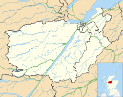
 Croy shown within the Inverness area
OS grid reference NH796495 Council area Highland Country Scotland Sovereign state United Kingdom Postcode district IV2 5 Police Northern Fire Highlands and Islands Ambulance Scottish EU Parliament Scotland UK Parliament Inverness, Nairn, Badenoch and Strathspey (UK Parliament constituency) Scottish Parliament Inverness and Nairn (Scottish Parliament constituency) List of places: UK • Scotland • Croy (Gaelic: Crothaigh[1]) is a village between Inverness and Nairn, in the Highland council area in Scotland. The village looks over the Moray firth and is located a few miles from Inverness Airport.
Contents
History
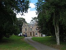
Kilravock Castle, the seat of the Clan Rose is located one mile from the village.
The site of the Battle of Culloden is located within the same parish. The local church was built in the 18th century[2]. An old manse is associated with the church. The village hall was built in 1907 with the aid of local funding[3]. The land where the hall stands was donated by the Kilravock estate.
Local community
The local area has expanded in recent years. Scotia homes have completed a development of 40 homes on the outskirts of the village[4]. A larger development of approximately 200 homes has been proposed for construction in the coming decades[5] but this has worried the local community[6].
The village contains a local shop and a primary school in the catchment area of Culloden Academy. Nearby Cantraybridge college also provides rural vocational training for adults with learning disabilities.
Kilravock Castle is open for bed and breakfast accommodation during the summer. Local bus services are run by Stagecoach in Inverness.
External links
References
- ^ http://www.linguae-celticae.org/dateien/Gaidhlig_Local_Studies_Vol_21_January_2005-a.pdf
- ^ http://www.sacredscotland.org.uk/church/croy-dalcross-parish-church
- ^ http://www.ambaile.org.uk/en/item/item_photograph.jsp?item_id=10121
- ^ http://suburban.scotia-homes.co.uk/home/dev_green_home.asp?did=23
- ^ http://www.highland.gov.uk/NR/rdonlyres/04888656-8C43-47A9-86BC-FFAB440ACFAC/0/MainsofCroyFarmPAAP.pdf
- ^ http://www.highland.gov.uk/NR/rdonlyres/BEB9ED34-CB94-4E76-8BFB-F7367C95A69C/0/HWLDPPP218CroyCCRedactednonerequired.pdf
Coordinates: 57°31′16″N 4°00′25″W / 57.521°N 4.007°W
Areas of Inverness The Aird · Ballifeary · Balloch · Balnafettack · Beechwood · Bught · Carse · Castle Heather · Clachnaharry · Cradlehall · Crown · Croy · Culcabock · Culduthel · Culloden · Dalneigh · Drakies · Drummond · Haugh · Hilton · Holm · Inshes · Kinmylies · Leachkin · Lochardil · Longman · Merkinch · Millburn · Milton · Milton of Leys · Muirtown · Ness Castle · Ness-Side · Raigmore · Scorguie · Seafield · Slackbuie · Smithton · South Kessock · Torvean · Westhill
Categories:- Populated places in Inverness committee area
- Highland geography stubs
Wikimedia Foundation. 2010.


