- Maydelle, Texas
-
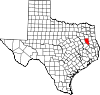
Maydelle — Unincorporated community — Location within the state of Texas
 Maydelle
Coordinates: 31°48′3″N 95°18′9″W / 31.80083°N 95.3025°WCoordinates: 31°48′3″N 95°18′9″W / 31.80083°N 95.3025°W Country United States State Texas County Cherokee Elevation 410 ft (125 m) Time zone Central (CST) (UTC-6) - Summer (DST) CDT (UTC-5) Area code(s) 430, 903 Maydelle is a small unincorporated community in Cherokee County, Texas, United States, located between Palestine and Rusk on U.S. Route 84. It lies at an elevation of 410 feet (125 m).
References
External links
- Kelly Gooch, Maydelle Preparing Centennial Celebration, Tyler Morning Telegraph, September 6, 2010. Retrieved 2010-09-06.
- Gale Owens, Maydelle, the lady and the town, Jacksonville Daily Progress, September 4, 2010. Retrieved 2010-09-05.
- Maydelle, TX from the Handbook of Texas Online
Municipalities and communities of Cherokee County, Texas County seat: Rusk Cities Gallatin | Jacksonville | New Summerfield | Reklaw‡ | Rusk | Troup‡
Towns Unincorporated
communitiesAtoy | Concord | Cove Springs | Craft | Dialville | Forest | Fry's Gap | Ironton | Larissa | Linwood | Maydelle | Mixon | Mount Selman | Oakland | Ponta | Reese | Salem | Tecula | Turney
Ghost towns Etna | Lone Star | New Birmingham
Footnotes ‡This populated place also has portions in an adjacent county or counties
Categories:- Populated places in Cherokee County, Texas
- Unincorporated communities in Texas
- East Texas geography stubs


Wikimedia Foundation. 2010.