- Mount Selman, Texas
-
Mount Selman, Texas — Unincorporated community — 
 Mount Selman, Texas
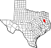
Coordinates: 32°04′06″N 95°17′03″W / 32.06833°N 95.28417°WCoordinates: 32°04′06″N 95°17′03″W / 32.06833°N 95.28417°W Country United States State Texas County Cherokee Elevation 696 ft (212 m) Time zone Central (CST) (UTC-6) - Summer (DST) CDT (UTC-5) Area code(s) 430, 903 GNIS feature ID 1342114[1] Mount Selman is an unincorporated community in Cherokee County, Texas, United States. It is located at the junction of U.S. Route 69, Farm to Market Road 177, and Farm to Market Road 855, 20 miles (32 km) north of Rusk.
History
Mount Selman was established in 1884 along the Kansas and Gulf Short Line Railroad. Its post office opened the same year as its creation. The community became a shipping center along the railroad for peaches, plums, and tomatoes. Its population peaked at 500 in 1914, and the town began to decline after that point. The post office closed in 1973, and the population was estimated at 200 in 2000.[2]
References
Municipalities and communities of Cherokee County, Texas County seat: Rusk Cities Gallatin | Jacksonville | New Summerfield | Reklaw‡ | Rusk | Troup‡
Towns Unincorporated
communitiesGhost towns Etna | Lone Star | New Birmingham
Footnotes ‡This populated place also has portions in an adjacent county or counties
Categories:- Populated places in Cherokee County, Texas
- Unincorporated communities in Texas
- East Texas geography stubs


Wikimedia Foundation. 2010.