- Reklaw, Texas
Infobox Settlement
official_name = Reklaw, Texas
settlement_type =City
nickname =
motto =
imagesize =
image_caption =
image_
mapsize = 250px
map_caption = Location of Reklaw, Texas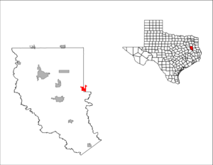
mapsize1 = 250px
map_caption1 =subdivision_type = Country
subdivision_name =United States
subdivision_type1 = State
subdivision_name1 =Texas
subdivision_type2 = Counties
subdivision_name2 = Cherokee, Ruskgovernment_footnotes =
government_type =
leader_title =
leader_name =
leader_title1 =
leader_name1 =
established_title =
established_date =unit_pref = Imperial
area_footnotes =area_magnitude =
area_total_km2 = 7.6
area_land_km2 = 7.6
area_water_km2 = 0.0
area_total_sq_mi = 2.9
area_land_sq_mi = 2.9
area_water_sq_mi = 0.0population_as_of = 2000
population_footnotes =
population_total = 327
population_density_km2 = 43.0
population_density_sq_mi = 111.3timezone = Central (CST)
utc_offset = -6
timezone_DST = CDT
utc_offset_DST = -5
elevation_footnotes =
elevation_m = 93
elevation_ft = 305
latd = 31 |latm = 51 |lats = 43 |latNS = N
longd = 94 |longm = 59 |longs = 6 |longEW = Wpostal_code_type =
ZIP code
postal_code = 75784
area_code = 936
blank_name = FIPS code
blank_info = 48-61508GR|2
blank1_name = GNIS feature ID
blank1_info = 1375694GR|3
website =
footnotes =Reklaw is a city in Cherokee and Rusk Counties in the
U.S. state ofTexas . The population was 327 at the 2000 census.The town is named for Margaret Walker, who donated the land for the townsite, but since a
Walker, Texas already existed elsewhere, the town simply spelled her name backwards.Geography
Reklaw is located at coor dms|31|51|43|N|94|59|6|W|city (31.861944, -94.984965)GR|1.
According to the
United States Census Bureau , the city has a total area of 2.9square mile s (7.6km² ), all of it land. Most of the city lies in Cherokee County, with only a small portion extending into Rusk County.Demographics
As of the
census GR|2 of 2000, there were 327 people, 130 households, and 88 families residing in the city. Thepopulation density was 111.3 people per square mile (42.9/km²). There were 150 housing units at an average density of 51.1/sq mi (19.7/km²). The racial makeup of the city was 85.02% White, 7.65% African American, 0.31% Native American, 5.20% from other races, and 1.83% from two or more races. Hispanic or Latino of any race were 13.46% of the population.There were 130 households out of which 24.6% had children under the age of 18 living with them, 59.2% were married couples living together, 6.2% had a female householder with no husband present, and 32.3% were non-families. 28.5% of all households were made up of individuals and 19.2% had someone living alone who was 65 years of age or older. The average household size was 2.52 and the average family size was 3.18.
In the city the population was spread out with 20.8% under the age of 18, 8.9% from 18 to 24, 24.2% from 25 to 44, 25.1% from 45 to 64, and 21.1% who were 65 years of age or older. The median age was 41 years. For every 100 females there were 94.6 males. For every 100 females age 18 and over, there were 97.7 males.
The median income for a household in the city was $29,167, and the median income for a family was $38,250. Males had a median income of $27,083 versus $18,750 for females. The
per capita income for the city was $16,092. About 6.5% of families and 16.1% of the population were below thepoverty line , including 25.0% of those under age 18 and 17.5% of those age 65 or over.Education
The City of Reklaw is served by the
Rusk Independent School District .References
External links

Wikimedia Foundation. 2010.