- Couargues
-
Couargues

 Couargues
Administration Country France Region Centre Department Cher Arrondissement Bourges Canton Sancerre Mayor Maurice Rat
(2008–2014)Statistics Elevation 141–155 m (463–509 ft)
(avg. 178 m/584 ft)Land area1 11.62 km2 (4.49 sq mi) Population2 210 (2008) - Density 18 /km2 (47 /sq mi) INSEE/Postal code 18074/ 18300 1 French Land Register data, which excludes lakes, ponds, glaciers > 1 km² (0.386 sq mi or 247 acres) and river estuaries. 2 Population without double counting: residents of multiple communes (e.g., students and military personnel) only counted once. Coordinates: 47°16′41″N 2°55′47″E / 47.2780555556°N 2.92972222222°E
Couargues is a commune in the Cher department in the Centre region of France.
Contents
Geography
A farming area comprising five hamlets situated between the banks of the Loire River and the canal lateral a la Loire, some 30 miles (48 km) northeast of Bourges at the junction of the D59 with the D206 and D259 roads.
Population
Historical population of Couargues 1962 1968 1975 1982 1990 1999 2008 199 238 224 211 207 228 210 Places of interest
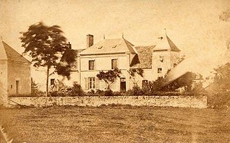 The presbytery
- The presbytery of St.Aignan, dating from the fifteenth century.
- Two watermills.
See also
References
External links
- Website about Couargues (French)
- Couargues on the Quid website (French)
Categories:- Communes of Cher


Wikimedia Foundation. 2010.