- Columbia, North Carolina
-
Columbia, North Carolina — Town — View of Albemarle Sound near Columbia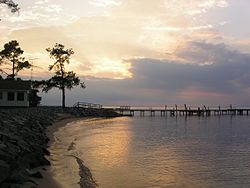 Location of Columbia, North Carolina
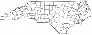
Coordinates: 35°55′4″N 76°14′59″W / 35.91778°N 76.24972°WCoordinates: 35°55′4″N 76°14′59″W / 35.91778°N 76.24972°W Country United States State North Carolina County Tyrrell Area - Total 0.5 sq mi (1.2 km2) - Land 0.5 sq mi (1.2 km2) - Water 0.0 sq mi (0.0 km2) Elevation 3 ft (1 m) Population (2008) - Total 803 - Density 1,756.7/sq mi (678.3/km2) Time zone Eastern (EST) (UTC-5) - Summer (DST) EDT (UTC-4) ZIP code 27925 Area code(s) 252 FIPS code 37-13940[1] GNIS feature ID 1019747[2] Website www.columbianc.com Columbia is a town in Tyrrell County, North Carolina, United States. The population was 819 at the 2000 census. It is the county seat of Tyrrell County.[3]
Contents
Geography
The Albemarle-Pamlico Peninsula is located in northeastern North Carolina, inshore of Nags Head and the Outer Banks in the Inner Banks region. The peninsula is framed by Albemarle Sound to the north, Alligator River to the east, and the Scuppernong River to the west. [1] [2] In addition to the Scuppernong River, Tyrrell County is bordered on the north by the Albemarle Sound, one of the East Coast's largest estuarine systems, and to the east by the Alligator River.
According to the United States Census Bureau, the town has a total area of 0.5 square miles (1.3 km2), all land.
History
Tyrrell County was formed in 1729 from Chowan, Bertie, Currituck and Pasquotank counties. Named for Sir John Tyrrell, one of the Lords Proprietors of the Carolina colony. Tyrrell County's original boundaries originally stretched westward from Roanoke Island to near present-day Tarboro. In 1870 the territory was divided and resulted in what is now known as Tyrrell, Martin, Washington, and Dare counties. Elizabethtown, later renamed Columbia, was established on the banks of the Scuppernong River in 1793 and became the Tyrrell County seat in 1799. [3]
Somerset Place State Historic Site, a representative antebellum plantation dating from 1785, is located near Columbia. Beginning in 1829, this was home to two generations of the Collins family-Josiah Collins III, his wife Mary, and their six sons. It was also home to more than three hundred enslaved men, women, and children of African descent whose lives and work are interpreted here as well. Somerset Place offers an insightful view of plantation life during the antebellum period. [4]
The earliest news paper in Columbia is known as the Eagle[5] and last known issue: Apr. 1, 1943.
Columbia's archaeology and National Register of Historic Places.[6].
Demographics
As of the census[1] of 2000, there were 819 people, 341 households, and 221 families residing in the town. The population density was 1,756.7 people per square mile (672.8/km²). There were 411 housing units at an average density of 881.6 per square mile (337.6/km²). The racial makeup of the town was 39.19% White, 52.26% African American, 0.12% Native American, 1.47% Asian, 5.13% from other races, and 1.83% from two or more races. Hispanic or Latino of any race were 7.33% of the population.
There were 341 households out of which 26.4% had children under the age of 18 living with them, 30.8% were married couples living together, 28.7% had a female householder with no husband present, and 34.9% were non-families. 31.4% of all households were made up of individuals and 17.9% had someone living alone who was 65 years of age or older. The average household size was 2.37 and the average family size was 2.93.
In the town the population was spread out with 26.6% under the age of 18, 9.4% from 18 to 24, 23.9% from 25 to 44, 20.5% from 45 to 64, and 19.5% who were 65 years of age or older. The median age was 39 years. For every 100 females there were 85.3 males. For every 100 females age 18 and over, there were 73.2 males.
The median income for a household in the town was $20,588, and the median income for a family was $21,563. Males had a median income of $19,821 versus $17,361 for females. The per capita income for the town was $12,216. About 27.9% of families and 33.7% of the population were below the poverty line, including 53.6% of those under age 18 and 13.5% of those age 65 or over.
Due to Columbia's proximity to the Outer Banks, land and property value have increased dramatically since 2000 and with that the local demographics have also changed. [7].
References
- ^ a b "American FactFinder". United States Census Bureau. http://factfinder.census.gov. Retrieved 2008-01-31.
- ^ "US Board on Geographic Names". United States Geological Survey. 2007-10-25. http://geonames.usgs.gov. Retrieved 2008-01-31.
- ^ "Find a County". National Association of Counties. http://www.naco.org/Counties/Pages/FindACounty.aspx. Retrieved 2011-06-07.
External links
- Town of Columbia
- IBX Arts, a not-for-profit art organization, based in Columbia, covering the Inner Banks
Municipalities and communities of Tyrrell County, North Carolina Town Columbia

Unincorporated
communitiesFort Landing | Jerry | Pleasant View
Categories:- Towns in North Carolina
- Populated places in North Carolina with African American majority populations
- Populated places in Tyrrell County, North Carolina
- County seats in North Carolina
- Populated places established in 1793

Wikimedia Foundation. 2010.