- Orphir
-
Not to be confused with Ophir.
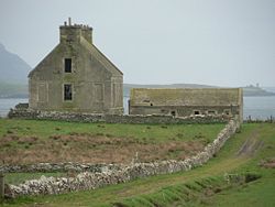
 The Hall of Clestrain, birthplace of John Rae, and currently derelict
Orphir (Old Norse: Jorfjara/Orfjara[1][2][3]) is a parish and settlement in Mainland, Orkney. It is averagely 9 miles (14 km) southwest of Kirkwall, and comprehends a seaboard tract of about 7 by 3½ miles (11 by 5½ km), and includes Cava and the Holm of Houton. The coast includes Houton Head, about 300 ft tall (91 m), but all elsewhere is nearly level; and the interior is an assemblage of vales and hills, the latter culminating at about 700 feet (210 m) above sea level, and commanding fine views.
A chief residence was the Hall of Clestrain; and chief antiquities include the ruins of Earl Paul's Palace, remains of pre-Reformation chapels, and several tumuli.
John Rae (30 September 1813 – 22 July 1893), the explorer of Canada's Arctic was born at the Hall of Clestrain in this parish.
References
- ^ Anderson, Joseph (Ed.) (1893) Orkneyinga Saga. Translated by Jón A. Hjaltalin & Gilbert Goudie. Edinburgh. James Thin and Mercat Press (1990 reprint). ISBN 0-901824-25-9
- ^ Pedersen, Roy (January 1992) Orkneyjar ok Katanes (map, Inverness, Nevis Print)
- ^ Haswell-Smith, Hamish (2004). The Scottish Islands. Edinburgh: Canongate. ISBN 1841954543.
This article incorporates text from - Wilson, Rev. John The Gazetteer of Scotland (Edinburgh, 1882) Published by W. & A.K. Johnstone
Orkney List of Orkney islands Inhabited Islands Mainland · Auskerry · Burray · Eday · Egilsay · Flotta · Gairsay · Graemsay · Hoy · North Ronaldsay · Papa Stronsay · Papa Westray · Rousay · Sanday · Shapinsay · South Ronaldsay · South Walls · Stronsay · Westray · WyreOther Islands Eynhallow · Helliar Holm · Lamb Holm · Switha · Swona · North West islands · North East islands · South West islands · South East islandsTowns and Villages Mainland Parishes Topics Coordinates: 58°56′N 3°9′W / 58.933°N 3.15°W
Categories:- Parishes of Orkney
- Orkney geography stubs
Wikimedia Foundation. 2010.
