- Egilsay
-
Egilsay Location 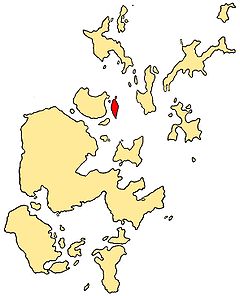
OS grid reference HY470301 Names Gaelic name ?Eaglais (see meaning) Norse name Egilsey Meaning of name Disputed - either Norse "Egil's island" or Norse "ey" + Celtic "eaglais" - "Church island" Area and summit Area 650 hectares (2.5 sq mi) Area rank 67 Highest elevation 35 metres (115 ft) Population Population 37 Population rank 58 out of 97 Groupings Island group Orkney Islands Local Authority Orkney 

References [1][2][3] If shown, area and population ranks are for all Scottish islands and all inhabited Scottish islands respectively. Population data is from 2001 census. 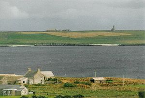 Egilsay seen from Rousay with St Magnus Church on the skyline
Egilsay is one of the Orkney Islands in Scotland, lying east of Rousay. The island is largely farmland and is known for its corncrakes.
Contents
St. Magnus Church
Extremely unusual for the Northern Isles, it has been suggested that Egilsay may have a partly Gaelic name.[1][2] While at first sight, it appears to be Egil's island, "Egil" being a Norse personal name, the Gaelic eaglais (Celtic "eccles") meaning church, may be part of the root, as the island is dominated by a church of pre-Norse foundation. The island of Kili Holm just to the north, may represent cille, a monastic cell.
The church itself has a highly unusual Irish style round tower, which itself is extremely rare in Scotland, and is unique in Orkney (though other examples are known to have existed in the past). The building is roofless and the tower has been slightly truncated, but it is otherwise complete. It is maintained by Historic Scotland as an Ancient Monument and Category A listed building.
Egilsay was the place where Saint Magnus was killed in 1117 by an axe blow to the head. While the church is dedicated to him, the foundation may be far older. For hundreds of years the story of St. Magnus, part of the Orkneyinga saga, was considered just a legend until a skull with a large crack in it, such as it had been stricken by an axe, was found in the walls of St. Magnus Cathedral in Kirkwall.
Transport
Orkney Ferries sail from the island to Tingwall on the Orkney Mainland via Wyre and Rousay.
References
- ^ a b Anderson, Joseph (Ed.) (1893) Orkneyinga Saga. Translated by Jón A. Hjaltalin & Gilbert Goudie. Edinburgh. James Thin and Mercat Press (1990 reprint). ISBN 0-901824-25-9
- ^ a b Haswell-Smith, Hamish. (2004) The Scottish Islands. Edinburgh. Canongate.
- ^ Pedersen, Roy (January 1992) Orkneyjar ok Katanes (map, Inverness, Nevis Print)
External links
North West Orkney Islands · Brough of Birsay · Damsay · Eday · Egilsay · Eynhallow · Faray · Gairsay · Holm of Faray · Holm of Papa · Holm of Scockness · Kili Holm · Papa Westray/Papay · Rousay · Rusk Holm · Sweyn Holm · Westray · Wyre ·
Orkney Inhabited Islands Mainland · Auskerry · Burray · Eday · Egilsay · Flotta · Gairsay · Graemsay · Hoy · North Ronaldsay · Papa Stronsay · Papa Westray · Rousay · Sanday · Shapinsay · South Ronaldsay · South Walls · Stronsay · Westray · WyreOther Islands Eynhallow · Helliar Holm · Lamb Holm · Switha · Swona · North West islands · North East islands · South West islands · South East islandsTowns and Villages Mainland Parishes Topics Islands of Scotland Northern Isles 
Hebrides Other Coordinates: 59°09′N 2°55′W / 59.15°N 2.917°W
Categories:- Islands of the Orkney Islands
- Orkney geography stubs


Wikimedia Foundation. 2010.