- Port Norris, New Jersey
Infobox Settlement
official_name = Port Norris, New Jersey
settlement_type = CDP
nickname =
motto =
imagesize =
image_caption =
image_
mapsize = 250x200px
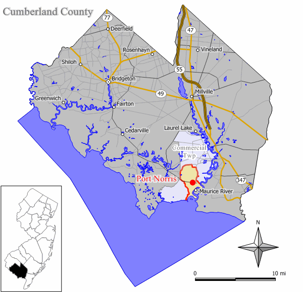
map_caption = Map of Port Norris CDP in Cumberland County
mapsize1 =
map_caption1 =subdivision_type = Country
subdivision_name =United States
subdivision_type1 = State
subdivision_name1 =New Jersey
subdivision_type2 = County
subdivision_name2 = Cumberland
government_footnotes =
government_type =
leader_title =
leader_name =
leader_title1 =
leader_name1 =
established_title =
established_date =area_footnotes =
area_magnitude =
area_total_km2 = 17.8
area_land_km2 = 16.5
area_water_km2 = 1.3
area_total_sq_mi = 6.9
area_land_sq_mi = 6.4
area_water_sq_mi = 0.5population_as_of = 2000
population_footnotes =
population_total = 1507
population_density_km2 = 91.3
population_density_sq_mi = 236.5timezone = Eastern (EST)
utc_offset = -5
timezone_DST = EDT
utc_offset_DST = -4
elevation_footnotes =
elevation_m = 3
elevation_ft = 10
latd = 39 |latm = 14 |lats = 47 |latNS = N
longd = 75 |longm = 2 |longs = 4 |longEW = Wpostal_code_type =
ZIP code
postal_code = 08349
area_code = 856
blank_name = FIPS code
blank_info = 34-60510GR|2
blank1_name = GNIS feature ID
blank1_info = 0879443GR|3
website =
footnotes =Port Norris is a
census-designated place and unincorporated area located within Commercial Township, in Cumberland County,New Jersey . It is part of the Vineland-Millville- BridgetonPrimary Metropolitan Statistical Area for statistical purposes. As of theUnited States 2000 Census , the CDP population was 1,507.Geography
Port Norris is located at coor dms|39|14|47|N|75|2|4|W|city (39.246257, -75.034465)GR|1, near the mouth of the
Maurice River .According to the
United States Census Bureau , the CDP has a total area of 17.8km² (6.9 mi²). 16.5 km² (6.4 mi²) of it is land and 1.3 km² (0.5 mi²) of it (7.28%) is water.Demographics
USCensusPop
1990=1701
2000=1507
footnote=source: [cite web
url=http://factfinder.census.gov/servlet/SAFFPopulation?_event=Search&geo_id=16000US3460030&_geoContext=01000US%7C04000US34%7C16000US3460030&_street=&_county=port+norris&_cityTown=port+norris&_state=04000US34&_zip=&_lang=en&_sse=on&ActiveGeoDiv=geoSelect&_useEV=&pctxt=fph&pgsl=160&_submenuId=population_0&ds_name=null&_ci_nbr=null&qr_name=null®=null%3Anull&_keyword=&_industry=
title=Population Finder: Port Norris CDP, New Jersey
publisher=U.S. Census Bureau
accessdate=2007-03-19] As of thecensus GR|2 of 2000, there were 1,507 people, 514 households, and 380 families residing in the CDP. Thepopulation density was 91.3/km² (236.5/mi²). There were 596 housing units at an average density of 36.1/km² (93.5/mi²). The racial makeup of the CDP was 58.26% White, 37.09% African American, 0.13% Native American, 0.20% Asian, 1.73% from other races, and 2.59% from two or more races. Hispanic or Latino of any race were 4.64% of the population.There were 514 households out of which 30.5% had children under the age of 18 living with them, 49.8% were married couples living together, 18.7% had a female householder with no husband present, and 25.9% were non-families. 20.6% of all households were made up of individuals and 11.7% had someone living alone who was 65 years of age or older. The average household size was 2.92 and the average family size was 3.36.
In the CDP the population was spread out with 27.4% under the age of 18, 7.9% from 18 to 24, 27.0% from 25 to 44, 20.8% from 45 to 64, and 16.9% who were 65 years of age or older. The median age was 37 years. For every 100 females there were 92.0 males. For every 100 females age 18 and over, there were 87.3 males.
The median income for a household in the CDP was $38,194, and the median income for a family was $42,813. Males had a median income of $36,513 versus $22,176 for females. The
per capita income for the CDP was $16,195. About 14.0% of families and 16.1% of the population were below thepoverty line , including 20.6% of those under age 18 and 7.2% of those age 65 or over.Bivalve and Shell Pile
In the Port Norris area are the towns of Bivalve and Shell Pile. They were both centers of the oystering industry. Bivalve was actually named after it, while the origin of "Shell Pile" is described in this 1939 excerpt of a WPA Guidebook to New Jersey:
"Shell Pile is named for the great heaps of oyster shells stacked outside the packing sheds. This is a community of about 1,000 Negroes living in wooden barracks erected on stilts over the salt marshes. Negroes here live their own lives in their own way, and present a united and rather hostile front from the rest of the world. Strange whites are not welcomed in Shell Pile."
The oystering industry reached its peak in 1955, declining by 1957 due to a disease called MSX which killed 90 percent of the oysters. Bivalve and Shell Pile are now mostly ghost towns, with a combined population of less than 50.
Drag Racing
On a late night in September 2007, an undercover operation to put a halt to the drag racing issue was commenced, and up to 62 people were caught participating in a major drag race gathering. About 208 summonses were issued and several cars were impounded.Fact|date=April 2008
References
External links
Wikimedia Foundation. 2010.

